METAR & TAF KOMA
Current METAR
Observed 19:52Z
KOMA 271952Z 09010KT 10SM FEW045 SCT120 SCT250 37/24 A2978 RMK AO2 SLP070 CB DSNT NE MOV SE T03670244
- Wind
- 090° @ 10 kt
- Visibility
- 10 SM
- Temp / Dew
- 37°C / 24°C
- Altimeter
- 29.78 inHg
- Clouds
- SCT
- Density alt
- 4,034 ft
- Ceiling
- Unlimited
- Rules
- VFR
Airport info & contacts
Manager on record, flight service, ARTCC, attendance schedule and pattern altitude — published by the FAA and refreshed every 28 days.
Location
- From city
- 3 NM NE
- VFR sectional
- OMAHA
- ARTCC
- ZMP · MINNEAPOLIS
- NOTAM facility
- OMA (NOTAM-D)
Airport manager
- Name
- MR. DAVID L. ROTH
- Phone
- 402-661-8000
- Address
- 4501 ABBOTT DRIVE, SUITE 2300, OMAHA NE 68110
Flight service · Hours
- FSS OLU
- COLUMBUS1-800-WX-BRIEF
- Attendance
- ALL
Frequencies
Tap any row to copy the frequency to your clipboard.
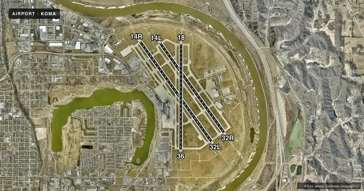
Runways & pattern
Full pagePattern entry · RWY 14R
LEFT TRAFFIC| Runway | Heading (°M) | Length | Surface | Traffic |
|---|---|---|---|---|
| 14R/32LFavored | 142° / 322° | 9,502 ft | CONC | Standard L |
| 14L/32R | 142° / 322° | 8,500 ft | CONC | 32R R |
| 18/36 | 178° / 358° | 8,154 ft | CONC | Standard L |
Runway end performance
| End | TORA | TODA | ASDA | LDA | VGSI | Approach lights | Obstruction |
|---|---|---|---|---|---|---|---|
| 14R | 9,502' | 9,502' | 9,502' | 9,502' | PAPI 4-box left(3°) | ALSF2 | — |
| 32L | 9,502' | 9,502' | 9,502' | 9,502' | PAPI 4-box right(3°) | MALSR | — |
| 14L | 8,500' | 8,500' | 8,500' | 8,500' | PAPI 4-box left(3°) | MALSR | — |
| 32R | 8,500' | 8,500' | 8,500' | 8,500' | PAPI 4-box right(3°) | ALSF2 | — |
| 18 | 8,153' | 8,153' | 8,153' | 8,013' | PAPI 4-box left(3°) | MALSR | — |
| 36 | 8,153' | 8,153' | 8,153' | 8,153' | PAPI 4-box left(3°) | MALSR | 110', brdg, 4573' from thr, 865' R of cntrln, slope 39 |
Declared distances in feet. TORA = takeoff run available, TODA = takeoff distance, ASDA = accelerate-stop, LDA = landing distance.
Airport sketch
Runways drawn to scale from FAA survey coordinates, rendered over satellite imagery. Not for navigation.
Approaches & charts
ILS · 6
Services on the field
Fuel grades, oxygen, maintenance, ramp storage and lighting — as declared to the FAA by the airport operator.
Fuel & services
- Fuel
- 100LLAA+
- Oxygen (bottled)
- High pressure
- Oxygen (bulk)
- HIGH/LOW
- Airframe repair
- Major
- Power plant repair
- Major
- Other services
- AFRT,AMB,AVNCS,CARGO,CHTR,INSTR,RNTL
Ramp & ground
- Transient storage
- Tie-down
- Hangar
- Landing fee
- No fee published
- Customs
- Not available
- Lighting schedule
- SEE RMK
- Beacon schedule
- SEE RMK
- Beacon
- White / Green (civil land)(WG)
- Wind indicator
- Lighted
- Segmented circle
- No
Fuel & FBOs
Cheapest 100LL and Jet A on the field and nearby. Always confirm with the FBO before taxi.
Airport notes
Surface conditions, obstructions, local procedures, lighting outages and other notes published with each FAA cycle.
General notes
- BIRDS ON AND INVOF ARPT.
- NOISE MITIGATION PROCEDURES PROHIBIT VFR PATTERNS FOR MILITARY TURBOJET ACFT BETWEEN 0500-1200Z.
- HLDG BAY AT RWY 32R CLSD EXC ACFT WITH WINGSPAN LESS THAN 79 FT. HLDG BAY AT RWY 18 CLSD EXC ACFT WITH WINGSPAN LESS THAN 79 FT. HLDG BAY AT RWY 32L CLSD EXC ACFT WITH WINGSPAN LESS THAN 118 FT.
- APN TRML RAMP TXL BTN TWY F1 & TWY A1 CLSD TO ACFT WINGSPAN MORE THAN 118 FT.
- TWY F1, F2, & F3 CLSD TO ACFT WINGSPAN MORE THAN 118FT.
- APN TRML RAMP WIP HVY EQPT BTN TWY A1 AND TWY F1.
- APN TRML RAMP BTN GATE A1 & GATE B19 CLSD.
Lighting notes
- 24 HRS
- 24 HRS
Runway surface & condition
- 14L/32RPCR VALUE: 848/R/C/W/T
- 14R/32LPCR VALUE: 848/R/C/W/T
- 18/36PCR VALUE: 848/R/C/W/T
Other notes
- MANAGERCEO OF OMAHA ARPT AUTH.
VFR map & nearby airports
VFR sectional. Tap any ICAO chip to open that airport.
Key facts · KOMA
Answer card- ICAO
- KOMA
- Name
- EPPLEY AIRFIELD
- Location
- OMAHA, NEBRASKA
- Elevation
- 984.5 ft MSL
- Traffic pattern altitude
- 1,984.5 ft MSL (1,000 AGL)
- Control tower
- Towered · 24
- Total runways
- 3
- Longest runway
- 14R/32L · 9,502 ft
- Published ILS approaches
- 6
- Published frequencies
- 14
- Magnetic variation
- 2°
- Current flight rules
- VFR
- Current wind
- 090° at 10 kt
- Favored runway now
- RWY 14R
Eppley Airfield sits in Omaha, Nebraska. Field elevation is 984.5 ft MSL. The airport has 3 runways. The longest is 9,502 ft on 14R/32L. The tower is open 24 hours. Airport lighting is also available 24 hours. Six ILS approaches are published here. Pattern altitude is not published in the facts, so verify the current Chart Supplement before you fly. For light piston traffic, plan on the standard 1,000 ft AGL unless the current published data says otherwise.
This is a busy Class C field with multiple concrete runways. Runway 14L/32R is 8,500 ft. Runway 18/36 is 8,154 ft. The published remarks also note birds on and near the airport, so keep a sharp scan on departure and arrival. The terminal ramp and some taxi areas have closures and work in progress. Large aircraft should check the current airport notes before taxiing, especially around the terminal ramp and the closed holding bays.
On the field, Atlantic Aviation carries 100LL and Jet A. Signature Aviation also carries 100LL and Jet A. If you are new to KOMA, get the latest taxi and ramp picture before you move. The airport manager is the CEO of the Omaha Airport Authority, so airport status and ramp access questions are best confirmed with the airport operator or the FBO directly by phone.