METAR & TAF KMLE
Current METAR
Observed 16:55Z
KMLE 271655Z AUTO 00000KT 10SM CLR 34/21 A2978 RMK AO2 T03380214
- Wind
- 000° @ 0 kt
- Visibility
- 10 SM
- Temp / Dew
- 34°C / 21°C
- Altimeter
- 29.78 inHg
- Clouds
- CLR
- Density alt
- 3,756 ft
- Ceiling
- Unlimited
- Rules
- VFR
Airport info & contacts
Manager on record, flight service, ARTCC, attendance schedule and pattern altitude — published by the FAA and refreshed every 28 days.
Location
- From city
- 7 NM SW
- VFR sectional
- OMAHA
- ARTCC
- ZMP · MINNEAPOLIS
- NOTAM facility
- MLE (NOTAM-D)
Airport manager
- Name
- DAVID ROTH
- Phone
- 402-661-8000
- Address
- 4501 ABBOTT DRIVE, SUITE 2300, OMAHA NE 68110-2689
Flight service · Hours
- FSS OLU
- COLUMBUS1-800-WX-BRIEF
- Attendance
- 0630-2100
Frequencies
Tap any row to copy the frequency to your clipboard.
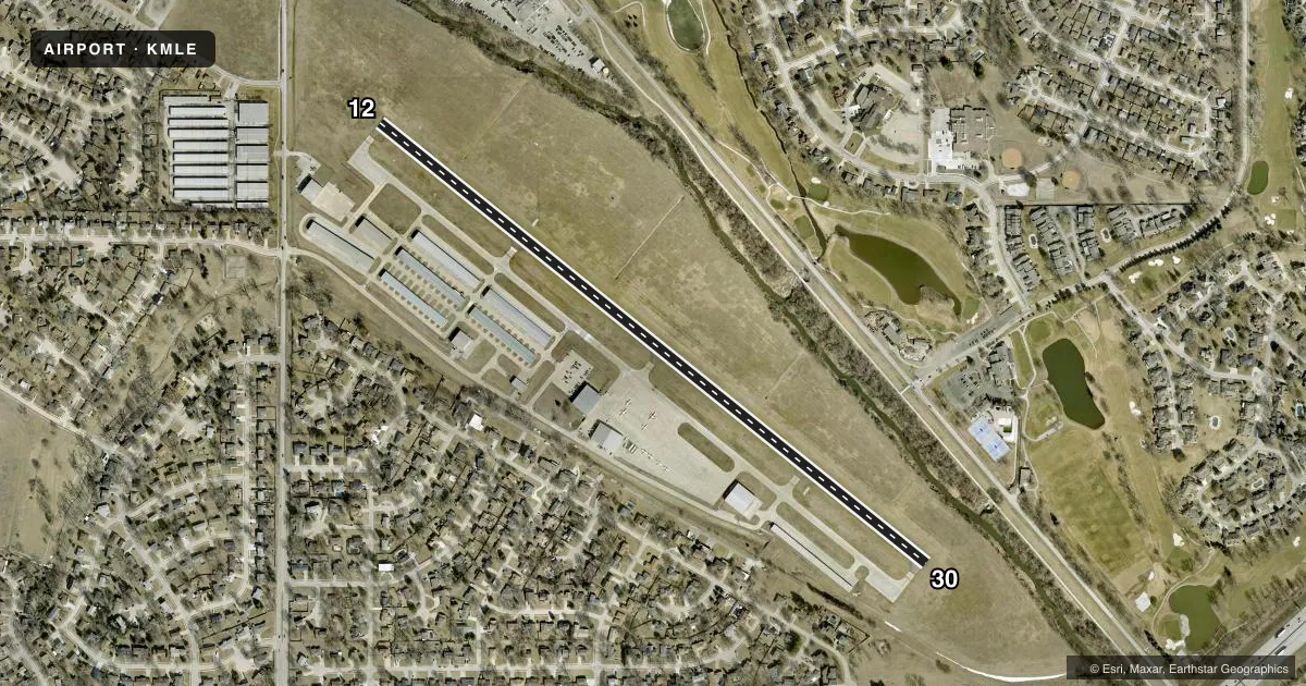
Runways & pattern
Full pagePattern entry · RWY 12
LEFT TRAFFICRunway end performance
| End | TORA | TODA | ASDA | LDA | VGSI | Approach lights | Obstruction |
|---|---|---|---|---|---|---|---|
| 12 | 3,801' | 3,801' | 3,801' | 3,588' | PAPI 2-box left(3.08°) | — | 17', road, 410' from thr, 285' R of cntrln, slope 12 |
| 30 | 3,801' | 3,801' | 3,588' | 3,801' | PAPI 2-box left(3.08°) | — | — |
Declared distances in feet. TORA = takeoff run available, TODA = takeoff distance, ASDA = accelerate-stop, LDA = landing distance.
Airport sketch
Runways drawn to scale from FAA survey coordinates, rendered over satellite imagery. Not for navigation.
Approaches & charts
Services on the field
Fuel grades, oxygen, maintenance, ramp storage and lighting — as declared to the FAA by the airport operator.
Fuel & services
- Fuel
- 100LLA1+
- Oxygen (bottled)
- HIGH/LOW
- Oxygen (bulk)
- HIGH/LOW
- Airframe repair
- Major
- Power plant repair
- Major
- Other services
- AMB,CHTR,INSTR,RNTL,SALES
Ramp & ground
- Transient storage
- Tie-down
- Hangar
- Landing fee
- No fee published
- Customs
- Not available
- Lighting schedule
- SEE RMK
- Beacon schedule
- SS-SR
- Beacon
- White / Green (civil land)(WG)
- Wind indicator
- Lighted
- Segmented circle
- No
Fuel & FBOs
Cheapest 100LL and Jet A on the field and nearby. Always confirm with the FBO before taxi.
Airport notes
Surface conditions, obstructions, local procedures, lighting outages and other notes published with each FAA cycle.
General notes
- MIL JETS OVERFLYING AT 3000 FT MSL.
- AFTER TKOF ON RY 30 ALTER HDG 20 DEGS TO THE R TO AVOID NOISE SENSITIVE AREA.
- NORMAL CALM & CROSS WIND TKOFS & LNDGS OF RY 12; NO INTXN TKOFS.
- RADIO CONTROLLED ACFT OCCASIONAL OPERATION 1.7 MI SW OF ARPT.
- VFR ACFT REQUESTING FLIGHT FLWG & IFR ACFT SHOULD CONTACT OMAHA APCH ON FREQ 125.4 PRIOR TO TAKING THE RY FOR CLNC/TRAFFIC ADVISORIES/GEN INFO.
- DEER ON & INVOF ARPT.
- SELF-SVC FUEL AVBL 24 HRS WITH CREDIT CARD.
Lighting notes
- ACTVT MIRL RY 12/30 & REIL RY 12 - CTAF.
Approach & departure obstructions
- 12APCH RATIO 36:1 FROM DSPLCD THR
Other notes
- 1FOR SVC AFT 2100 CALL 402-953-9905 OR 402-690-3099.
VFR map & nearby airports
VFR sectional. Tap any ICAO chip to open that airport.
Key facts · KMLE
Answer card- ICAO
- KMLE
- Name
- MILLARD
- Location
- OMAHA, NEBRASKA
- Elevation
- 1,050.7 ft MSL
- Traffic pattern altitude
- 2,050.7 ft MSL (1,000 AGL)
- Control tower
- Non-towered (use CTAF)
- Total runways
- 1
- Longest runway
- 12/30 · 3,801 ft
- Published ILS approaches
- 0
- Published frequencies
- 5
- Magnetic variation
- 6°
- Current flight rules
- VFR
- Current wind
- 000° at 0 kt
- Favored runway now
- –
Millard Airport sits in Omaha, Nebraska. The field elevation is 1,050.7 ft MSL. It has one runway, 12/30, which is 3,801 ft long. There is no control tower. No ILS approaches are published here.
The published pattern altitude is not listed, so use the standard 1,000 ft AGL for light piston operations unless the current Chart Supplement says otherwise. Oracle Aviation is on the field. It carries 100LL and Jet A Prist. Self-serve fuel is available 24 hours with a credit card.
For VFR flight following or IFR coordination, Omaha Approach should be contacted on 125.4 before taking the runway. The airport remarks also note deer on and near the field. Runway 30 departures call for a 20 degree right turn after liftoff to avoid a noise sensitive area. Normal calm and crosswind operations use runway 12. No intersection takeoffs are permitted. Medium intensity runway lights are on 12/30. REILs are on runway 12. The lights are activated by the CTAF.
A first-time pilot should pay attention to the displaced threshold on runway 12. The published approach ratio from that threshold is 36 to 1. Military jets also overfly at 3,000 ft MSL. Expect traffic overhead while you are working the pattern.