METAR & TAF KCBF
Current METAR
Observed 20:15Z
KCBF 272015Z AUTO 08008KT 9SM CLR A2978 RMK AO2
- Wind
- 080° @ 8 kt
- Visibility
- 9 SM
- Temp / Dew
- —
- Altimeter
- 29.78 inHg
- Clouds
- CLR
- Density alt
- —
- Ceiling
- Unlimited
- Rules
- VFR
Airport info & contacts
Manager on record, flight service, ARTCC, attendance schedule and pattern altitude — published by the FAA and refreshed every 28 days.
Location
- From city
- 4 NM E
- VFR sectional
- OMAHA
- ARTCC
- ZMP · MINNEAPOLIS
- NOTAM facility
- CBF (NOTAM-D)
Airport manager
- Name
- ANDY BILLER
- Phone
- 712-322-2284
- Address
- 101 MCCANDLESS LANE, COUNCIL BLUFFS IA 51503
Flight service · Hours
- FSS FOD
- FORT DODGE1-800-WX-BRIEF
- Attendance
- 0700-2000
Frequencies
Tap any row to copy the frequency to your clipboard.
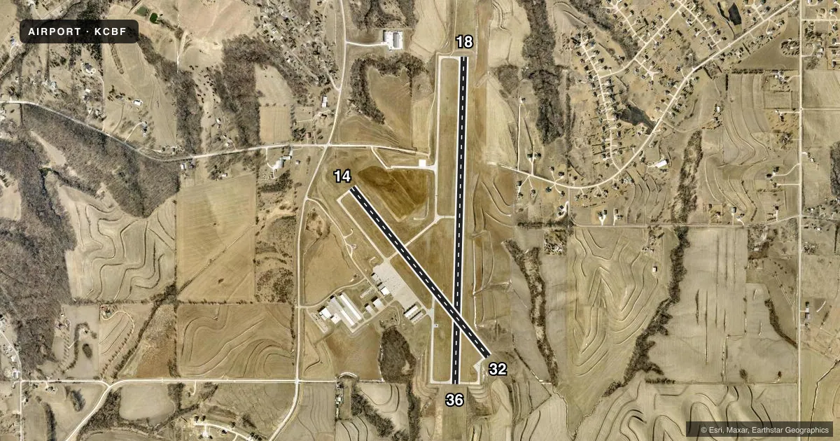
Runways & pattern
Full pagePattern entry · RWY 14
LEFT TRAFFIC| Runway | Heading (°M) | Length | Surface | Traffic |
|---|---|---|---|---|
| 18/36 | 176° / 356° | 5,500 ft | CONC | Standard L |
| 14/32Favored | 136° / 316° | 3,650 ft | CONC | Standard L |
Runway end performance
| End | TORA | TODA | ASDA | LDA | VGSI | Approach lights | Obstruction |
|---|---|---|---|---|---|---|---|
| 18 | — | — | — | — | PAPI 2-box left(3°) | — | — |
| 36 | — | — | — | — | PAPI 2-box left(3°) | — | — |
| 14 | — | — | — | — | PAPI 2-box left(3°) | — | 32', tree, 1191' from thr, 236' R of cntrln, slope 30 |
| 32 | — | — | — | — | PAPI 2-box left(3.5°) | — | — |
Declared distances in feet. TORA = takeoff run available, TODA = takeoff distance, ASDA = accelerate-stop, LDA = landing distance.
Airport sketch
Runways drawn to scale from FAA survey coordinates, rendered over satellite imagery. Not for navigation.
Approaches & charts
ILS · 1
Services on the field
Fuel grades, oxygen, maintenance, ramp storage and lighting — as declared to the FAA by the airport operator.
Fuel & services
- Fuel
- 100LLA
- Oxygen (bottled)
- Low pressure
- Oxygen (bulk)
- Not available
- Airframe repair
- Major
- Power plant repair
- Major
- Other services
- AVNCS,CHTR,INSTR,RNTL,SALES
Ramp & ground
- Transient storage
- Tie-down
- Hangar
- Landing fee
- No fee published
- Customs
- Not available
- Lighting schedule
- SEE RMK
- Beacon schedule
- SS-SR
- Beacon
- White / Green (civil land)(WG)
- Wind indicator
- Lighted
- Segmented circle
- No
Fuel & FBOs
Cheapest 100LL and Jet A on the field and nearby. Always confirm with the FBO before taxi.
Airport notes
Surface conditions, obstructions, local procedures, lighting outages and other notes published with each FAA cycle.
Lighting notes
- ACTVT MIRL RWY 14/32; HIRL RWY 18/36; REIL RWYS 14, 32, 18 & 36 - CTAF. PAPI RWYS 14, 32, 18 & 36 ARE ON 24/7.
Runway surface & condition
- 14/32RY 14 PREFERRED CALM WIND RUNWAY.
VFR map & nearby airports
VFR sectional. Tap any ICAO chip to open that airport.
Key facts · KCBF
Answer card- ICAO
- KCBF
- Name
- COUNCIL BLUFFS MUNI
- Location
- COUNCIL BLUFFS, IOWA
- Elevation
- 1,244.8 ft MSL
- Traffic pattern altitude
- 2,244.8 ft MSL (1,000 AGL)
- Control tower
- Non-towered (use CTAF)
- Total runways
- 2
- Longest runway
- 18/36 · 5,500 ft
- Published ILS approaches
- 1
- Published frequencies
- 5
- Magnetic variation
- 5°
- Current flight rules
- VFR
- Current wind
- 080° at 8 kt
- Favored runway now
- RWY 14
Council Bluffs Muni sits in Council Bluffs, Iowa. Field elevation is 1,244.8 ft MSL. The airport has two concrete runways. The longest is 5,500 ft on 18/36. There is no control tower, so expect CTAF traffic and self-announced sequencing. Pattern altitude is not published. Use 1,000 ft AGL for light piston operations unless the current Chart Supplement says otherwise.
There is one ILS approach. It serves runway 36. The airport uses Omaha approach and departure frequencies. Runway 14 is the preferred calm wind runway. That is useful to know before you start planning your arrival. Runway 14/32 has medium intensity lights. Runway 18/36 has high intensity lights. REILs are activated by CTAF on all runway ends. PAPI is available on 14, 32, 18 and 36 all day, every day.
No on-field FBOs are listed in the facts. Verify current fuel and service options with the airport operator or by calling the field directly before you go. For a first-time arrival, watch the elevation and plan for a little more performance margin than a lowland strip. The field is non-towered, so listen early, make your position calls and expect mixed traffic on both runways.