METAR & TAF KHNR
Current METAR
Observed 21:35Z
KHNR 272135Z AUTO 21005KT 10SM CLR 32/26 A2980 RMK A01
- Wind
- 210° @ 5 kt
- Visibility
- 10 SM
- Temp / Dew
- 32°C / 26°C
- Altimeter
- 29.80 inHg
- Clouds
- CLR
- Density alt
- 3,715 ft
- Ceiling
- Unlimited
- Rules
- VFR
Airport info & contacts
Manager on record, flight service, ARTCC, attendance schedule and pattern altitude — published by the FAA and refreshed every 28 days.
Location
- From city
- 3 NM SW
- VFR sectional
- OMAHA
- ARTCC
- ZMP · MINNEAPOLIS
- NOTAM facility
- HNR (NOTAM-D)
Airport manager
- Name
- SCOTT PIGSLEY
- Phone
- 712-744-3366
- Address
- 610 HWY 59, HARLAN IA 51537
Flight service · Hours
- FSS FOD
- FORT DODGE1-800-WX-BRIEF
- Attendance
- APR-SEP · MON-FRI · 0800-1700
- OCT-MAR · MON-FRI · 0800-1600
Frequencies
Tap any row to copy the frequency to your clipboard.
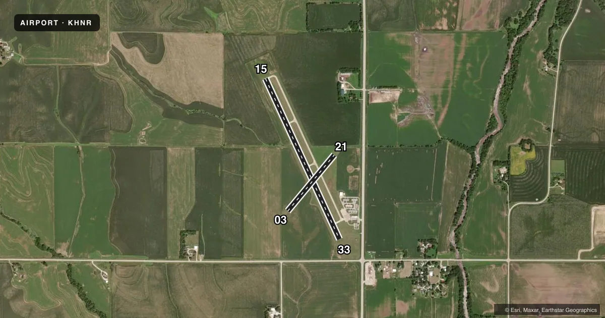
Runways & pattern
Full pagePattern entry · RWY 21
LEFT TRAFFIC| Runway | Heading (°M) | Length | Surface | Traffic |
|---|---|---|---|---|
| 15/33 | 150° / 330° | 4,100 ft | CONC | Standard L |
| 03/21Favored | 35° / 215° | 1,693 ft | TURF | Standard L |
Runway end performance
| End | TORA | TODA | ASDA | LDA | VGSI | Approach lights | Obstruction |
|---|---|---|---|---|---|---|---|
| 15 | — | — | — | — | PAPI 2-box left(3°) | — | 14', gnd, 490' from thr, 200' R of cntrln, slope 20 |
| 33 | — | — | — | — | PAPI 2-box left(3°) | — | 16', road, 528' from thr, 0' R of cntrln, slope 20 |
| 03 | — | — | — | — | — | — | 8', fence, 200' from thr, 0' R of cntrln, slope 25 |
| 21 | — | — | — | — | — | — | 10', fence, 295' from thr, 0' R of cntrln, slope 29 |
Declared distances in feet. TORA = takeoff run available, TODA = takeoff distance, ASDA = accelerate-stop, LDA = landing distance.
Airport sketch
Runways drawn to scale from FAA survey coordinates, rendered over satellite imagery. Not for navigation.
Approaches & charts
Services on the field
Fuel grades, oxygen, maintenance, ramp storage and lighting — as declared to the FAA by the airport operator.
Fuel & services
- Fuel
- 100LLA
- Oxygen (bottled)
- Not available
- Oxygen (bulk)
- Not available
- Airframe repair
- Not available
- Power plant repair
- Not available
- Other services
- INSTR
Ramp & ground
- Transient storage
- Tie-down
- Hangar
- Landing fee
- No fee published
- Customs
- Not available
- Lighting schedule
- SEE RMK
- Beacon schedule
- SS-SR
- Beacon
- White / Green (civil land)(WG)
- Wind indicator
- Lighted
- Segmented circle
- No
Fuel & FBOs
Cheapest 100LL and Jet A on the field and nearby. Always confirm with the FBO before taxi.
Airport notes
Surface conditions, obstructions, local procedures, lighting outages and other notes published with each FAA cycle.
General notes
- RY 15 IS CALM WIND RY.
- FOR CD CTC OMAHA APCH AT 402-682-4395.
- SCOTT MCLAUGHLIN, CHAIRMAN, ARPT COMMISSION
Lighting notes
- ACTVT REIL RWY 15 & 33; PAPI RWY 15 & 33; MIRL RWY 15/33 - CTAF.
Fuel notes
- 100LLSELF SERVE OR FULL SVC ON REQ.
- ASELF SERVE OR FULL SVC ON REQ.
Approach & departure obstructions
- 03RY 03/21 THLDS & SIDES MARKED WITH CONES.
Other notes
- OWNERDAN KLEINPASTE, CHAIRMAN, ARPT COMM.
VFR map & nearby airports
VFR sectional. Tap any ICAO chip to open that airport.
Key facts · KHNR
Answer card- ICAO
- KHNR
- Name
- HARLAN MUNI
- Location
- HARLAN, IOWA
- Elevation
- 1,230.9 ft MSL
- Traffic pattern altitude
- 2,230.9 ft MSL (1,000 AGL)
- Control tower
- Non-towered (use CTAF)
- Total runways
- 2
- Longest runway
- 15/33 · 4,100 ft
- Published ILS approaches
- 0
- Published frequencies
- 4
- Magnetic variation
- 5°
- Current flight rules
- VFR
- Current wind
- 210° at 5 kt
- Favored runway now
- RWY 21
Harlan Muni is in Harlan, Iowa. The field elevation is 1,230.9 ft MSL. It has two runways. The longest is 15/33 at 4,100 ft of concrete. There is no control tower. No ILS approaches are published. Pattern altitude is not published, so use the standard 1,000 ft AGL for light piston traffic unless the current Chart Supplement says otherwise.
Harlan Flying Service is on the field. It carries 100LL and Jet A. Fuel is available self-serve or full service on request. Runway 15 is the calm wind runway. Runway 15/33 has medium intensity lights controlled by CTAF. REILs and PAPI are installed on 15 and 33. Runway 03/21 has cone-marked thresholds and sides, so it is the shorter turf option at 1,693 ft.
For IFR work, Omaha Approach handles clearance delivery and approach or departure services. The published frequencies are 122.8 for CTAF and UNICOM. 124.5 and 263.0 are for Omaha Approach. This is a non-towered field with a higher elevation than many Iowa airports, so plan for wind, density altitude and runway length with care. If you need any current noise or operational guidance, check the current FAA Chart Supplement or call the airport operator before departure.