METAR & TAF KADU
Current METAR
Observed 07:15Z
KADU 270715Z AUTO 18005KT 10SM 28/26 A2980 RMK AO2
- Wind
- 180° @ 5 kt
- Visibility
- 10 SM
- Temp / Dew
- 28°C / 26°C
- Altimeter
- 29.80 inHg
- Clouds
- Clear
- Density alt
- 3,306 ft
- Ceiling
- Unlimited
- Rules
- VFR
Airport info & contacts
Manager on record, flight service, ARTCC, attendance schedule and pattern altitude — published by the FAA and refreshed every 28 days.
Location
- From city
- 1 NM SE
- VFR sectional
- OMAHA
- ARTCC
- ZMP · MINNEAPOLIS
- NOTAM facility
- ADU (NOTAM-D)
Airport manager
- Name
- LOU HERBERS
- Phone
- (712) 563-4440
- Address
- 2110 HIGHWAY 71, AUDUBON IA 50025
Flight service · Hours
- FSS FOD
- FORT DODGE1-800-WX-BRIEF
- Attendance
- Unattended
Frequencies
Tap any row to copy the frequency to your clipboard.
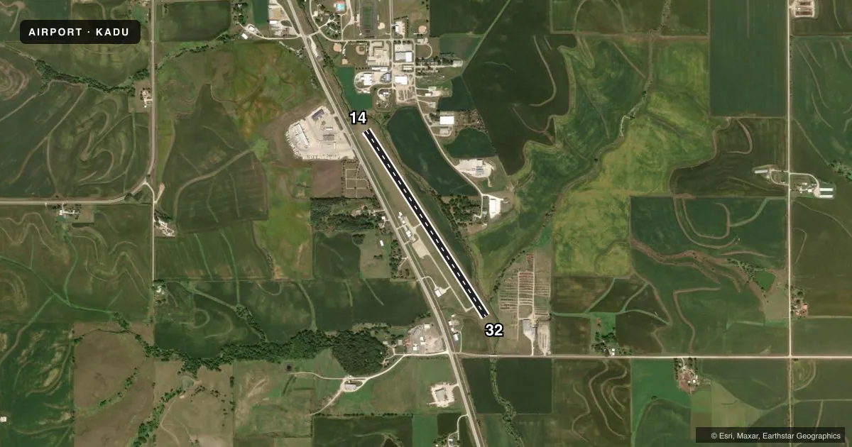
Runways & pattern
Full pagePattern entry · RWY 14
LEFT TRAFFICRunway end performance
| End | TORA | TODA | ASDA | LDA | VGSI | Approach lights | Obstruction |
|---|---|---|---|---|---|---|---|
| 14 | — | — | — | — | PAPI 2-box left(3°) | — | 41', tree, 1247' from thr, 30' R of cntrln, slope 25 |
| 32 | — | — | — | — | PAPI 2-box left(3.25°) | — | 20', brdg, 613' from thr, 208' R of cntrln, slope 20 |
Declared distances in feet. TORA = takeoff run available, TODA = takeoff distance, ASDA = accelerate-stop, LDA = landing distance.
Airport sketch
Runways drawn to scale from FAA survey coordinates, rendered over satellite imagery. Not for navigation.
Approaches & charts
Services on the field
Fuel grades, oxygen, maintenance, ramp storage and lighting — as declared to the FAA by the airport operator.
Fuel & services
- Fuel
- Not available
- Oxygen (bottled)
- Not available
- Oxygen (bulk)
- Not available
- Airframe repair
- Not available
- Power plant repair
- Not available
- Other services
- AGRI
Ramp & ground
- Transient storage
- Tie-down
- Hangar
- Landing fee
- No fee published
- Customs
- Not available
- Lighting schedule
- SEE RMK
- Beacon schedule
- SS-SR
- Beacon
- White / Green (civil land)(WG)
- Wind indicator
- Lighted
- Segmented circle
- No
Fuel & FBOs
Cheapest 100LL and Jet A on the field and nearby. Always confirm with the FBO before taxi.
Airport notes
Surface conditions, obstructions, local procedures, lighting outages and other notes published with each FAA cycle.
General notes
- RY 14 HAS 64 FT LGTD POLE 1200 FT FM THLD 350 FT L.
- FOR CD CTC MINNEAPOLIS ARTCC AT 651-463-5588.
Lighting notes
- ROTG BCN OTS INDEFLY.
- ACTVT MIRL RY 14/32 AND PAPI & REIL RYS 14 & 32 - CTAF.
Approach & departure obstructions
- 14RWY 14 APCH SLOPE 32:1 TO DSPLCD THLD.
Other notes
- CTAF OTS INDEFLY.
- OWNERLOU HERBERS CHAIRMAN OFFICE# 712-563-4440.
VFR map & nearby airports
VFR sectional. Tap any ICAO chip to open that airport.
Key facts · KADU
Answer card- ICAO
- KADU
- Name
- AUDUBON COUNTY
- Location
- AUDUBON, IOWA
- Elevation
- 1,287.7 ft MSL
- Traffic pattern altitude
- 2,287.7 ft MSL (1,000 AGL)
- Control tower
- Non-towered (use CTAF)
- Total runways
- 1
- Longest runway
- 14/32 · 3,641 ft
- Published ILS approaches
- 0
- Published frequencies
- 2
- Magnetic variation
- 4°
- Current flight rules
- VFR
- Current wind
- 180° at 5 kt
- Favored runway now
- RWY 14
Audubon County Airport (KADU) sits in Audubon, Iowa. The field elevation is 1,287.7 ft MSL. It has one runway. Runway 14/32 is 3,641 ft long with a concrete surface. There is no control tower. No ILS approaches are published here.
The pattern altitude is not published. Use the standard 1,000 ft AGL for light piston operations unless the current Chart Supplement says otherwise. That puts the pattern at about 2,287.7 ft MSL based on the listed field elevation. CTAF and UNICOM are both listed as 122.8. The published remarks say CTAF is out of service indefinitely. Check the current Chart Supplement and contact the airport operator before you go.
Published remarks also note a 64-foot lighted pole 1,200 feet from the threshold on the left side of runway 14. The runway 14 approach slope is 32 to 1 to the displaced threshold. Medium intensity runway lights, PAPI and REIL on both ends are activated by CTAF. The rotating beacon is out of service indefinitely. There are no on-field FBOs listed. For clearance delivery, contact Minneapolis ARTCC at 651-463-5588. Pilots should plan for a non-towered arrival with no published ILS and review the current Chart Supplement before flying in.