METAR & TAF KGFZ
KGFZ does not publish a METAR.
Showing the nearest reporting station: KCSQ (CRESTON MUNI) · 18.7 NM away. Conditions at KGFZ may differ.
METAR · KCSQ
Observed 06:55Z
KCSQ 270655Z AUTO 19009KT 10SM CLR 27/25 A2983 RMK AO2
- Wind
- 190° @ 9 kt
- Visibility
- 10 SM
- Temp / Dew
- 27°C / 25°C
- Altimeter
- 29.83 inHg
- Clouds
- CLR
- Density alt
- 3,242 ft
- Ceiling
- Unlimited
- Rules
- VFR
Airport info & contacts
Manager on record, flight service, ARTCC, attendance schedule and pattern altitude — published by the FAA and refreshed every 28 days.
Location
- From city
- 2 NM NE
- VFR sectional
- OMAHA
- ARTCC
- ZMP · MINNEAPOLIS
- NOTAM facility
- FOD (NOTAM-D)
Airport manager
- Name
- BRIAN HOADLEY
- Phone
- 641-743-2183
- Address
- 202 SOUTH 1ST STREET, GREENFIELD IA 50849
Flight service · Hours
- FSS FOD
- FORT DODGE1-800-WX-BRIEF
- Attendance
- Unattended
Frequencies
Tap any row to copy the frequency to your clipboard.
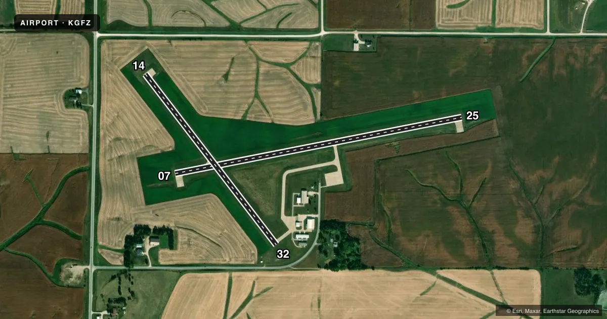
Runways & pattern
Full pagePattern entry · RWY 14
LEFT TRAFFIC| Runway | Heading (°M) | Length | Surface | Traffic |
|---|---|---|---|---|
| 07/25 | 74° / 254° | 3,400 ft | CONC | Standard L |
| 14/32Favored | 138° / 318° | 2,500 ft | CONC | Standard L |
Runway end performance
| End | TORA | TODA | ASDA | LDA | VGSI | Approach lights | Obstruction |
|---|---|---|---|---|---|---|---|
| 14 | 2,250' | 2,250' | 2,500' | 2,500' | — | — | — |
| 32 | 2,500' | 2,500' | 2,500' | 2,250' | — | — | 16', road, 320' from thr, 250' R of cntrln, slope 7 |
Declared distances in feet. TORA = takeoff run available, TODA = takeoff distance, ASDA = accelerate-stop, LDA = landing distance.
Airport sketch
Runways drawn to scale from FAA survey coordinates, rendered over satellite imagery. Not for navigation.
Approaches & charts
Services on the field
Fuel grades, oxygen, maintenance, ramp storage and lighting — as declared to the FAA by the airport operator.
Fuel & services
- Fuel
- 100LL
- Oxygen (bottled)
- Not available
- Oxygen (bulk)
- Not available
Ramp & ground
- Transient storage
- Tie-down
- Landing fee
- No fee published
- Customs
- Not available
- Lighting schedule
- SEE RMK
- Beacon schedule
- SS-SR
- Beacon
- White / Green (civil land)(WG)
- Wind indicator
- Lighted
- Segmented circle
- No
Fuel & FBOs
Cheapest 100LL and Jet A on the field and nearby. Always confirm with the FBO before taxi.
Airport notes
Surface conditions, obstructions, local procedures, lighting outages and other notes published with each FAA cycle.
General notes
- PHONE ON ARPT.
- INADQT CLNC FOR HLDG ON TURNAROUND AT THLD OF RWY 14.
- RY 25 IS CALM WIND RY.
- FOR CD CTC MINNEAPOLIS ARTCC AT 651-463-5588.
Lighting notes
- ACTVT MIRL RY 7/25 - CTAF. MIRL RY 07/25 PRESET ON LOW INTST; TO INCR INTST - CTAF.
Approach & departure obstructions
- 3218' HANGAR 50' FROM RWY END AND 250' RIGHT
Other notes
- WIND INDICATOR LIGHTS ACTIVATED VIA 122.9.
VFR map & nearby airports
VFR sectional. Tap any ICAO chip to open that airport.
Key facts · KGFZ
Answer card- ICAO
- KGFZ
- Name
- GREENFIELD MUNI
- Location
- GREENFIELD, IOWA
- Elevation
- 1,363.6 ft MSL
- Traffic pattern altitude
- 2,363.6 ft MSL (1,000 AGL)
- Control tower
- Non-towered (use CTAF)
- Total runways
- 2
- Longest runway
- 07/25 · 3,400 ft
- Published ILS approaches
- 0
- Published frequencies
- 1
- Magnetic variation
- 4°
- Current flight rules
- VFR
- Current wind
- 190° at 9 kt
- Favored runway now
- RWY 14
Greenfield Muni sits in Greenfield, Iowa. The field elevation is 1,363.6 ft MSL. It has two concrete runways. The longest is 3,400 ft on runway 07/25. There is no control tower. CTAF is 122.9. No ILS approaches are published here.
Pattern altitude is not published. Use the standard 1,000 ft AGL unless the current Chart Supplement says otherwise. That puts the traffic pattern at about 2,363.6 ft MSL based on the field elevation. The on-field FBO is Greenfield Municipal Airport. It carries AVGAS 100LL.
A few remarks matter for planning. Runway 25 is listed as the calm wind runway. Runway 07/25 lights are activated on CTAF. They start at low intensity. Use the CTAF frequency to increase intensity. There is also a phone on the airport. Clearance delivery goes through Minneapolis ARTCC at 651-463-5588. Watch the departure end of runway 32. There is an 18-foot hangar 50 ft from the end of the runway. It sits 250 ft right of centerline. For a first visit, the main things are the non-towered setup, the lack of ILS and the high field elevation for a small Iowa airport. Check density altitude and performance before you go.