METAR & TAF KCSQ
Current METAR
Observed 18:35Z
KCSQ 271835Z AUTO 00000KT 9SM CLR 29/26 A2978 RMK AO2
- Wind
- 000° @ 0 kt
- Visibility
- 9 SM
- Temp / Dew
- 29°C / 26°C
- Altimeter
- 29.78 inHg
- Clouds
- CLR
- Density alt
- 3,465 ft
- Ceiling
- Unlimited
- Rules
- VFR
Airport info & contacts
Manager on record, flight service, ARTCC, attendance schedule and pattern altitude — published by the FAA and refreshed every 28 days.
Location
- From city
- 3 NM S
- VFR sectional
- OMAHA
- ARTCC
- ZMP · MINNEAPOLIS
- NOTAM facility
- CSQ (NOTAM-D)
Airport manager
- Name
- TYLER WEST
- Phone
- 641-278-0203
- Address
- 1945 CHERRY STREET ROAD, CRESTON IA 50801
Flight service · Hours
- FSS FOD
- FORT DODGE1-800-WX-BRIEF
- Attendance
- MON-FRI · 0800-1700
- SAT-SUN · ON CALL
Frequencies
Tap any row to copy the frequency to your clipboard.
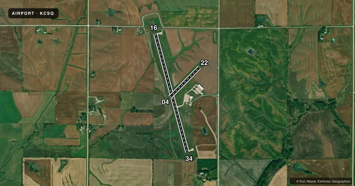
Runways & pattern
Full pagePattern entry · RWY 16
LEFT TRAFFIC| Runway | Heading (°M) | Length | Surface | Traffic |
|---|---|---|---|---|
| 16/34 | 161° / 341° | 4,901 ft | CONC | Standard L |
| 04/22 | 41° / 221° | 1,692 ft | TURF | Standard L |
Runway end performance
| End | TORA | TODA | ASDA | LDA | VGSI | Approach lights | Obstruction |
|---|---|---|---|---|---|---|---|
| 16 | — | — | — | — | PAPI 2-box left(3°) | — | 13', fence, 520' from thr, 0' R of cntrln, slope 24 |
| 34 | — | — | — | — | PAPI 2-box left(3°) | — | 5', tree, 326' from thr, 135' R of cntrln, slope 25 |
Declared distances in feet. TORA = takeoff run available, TODA = takeoff distance, ASDA = accelerate-stop, LDA = landing distance.
Airport sketch
Runways drawn to scale from FAA survey coordinates, rendered over satellite imagery. Not for navigation.
Approaches & charts
Services on the field
Fuel grades, oxygen, maintenance, ramp storage and lighting — as declared to the FAA by the airport operator.
Fuel & services
- Fuel
- 100LLA
- Airframe repair
- Minor
- Power plant repair
- Minor
Ramp & ground
- Transient storage
- Tie-down
- Hangar
- Landing fee
- No fee published
- Customs
- Not available
- Lighting schedule
- SEE RMK
- Beacon schedule
- SS-SR
- Beacon
- White / Green (civil land)(WG)
- Wind indicator
- Lighted
- Segmented circle
- No
Fuel & FBOs
Cheapest 100LL and Jet A on the field and nearby. Always confirm with the FBO before taxi.
Airport notes
Surface conditions, obstructions, local procedures, lighting outages and other notes published with each FAA cycle.
General notes
- REMOTE CTL OPS INVOF ARPT.
- FOR CD CTC MINNEAPOLIS ARTCC AT 651-463-5588.
Lighting notes
- ACTVT REIL RWY 16 & 34; PAPI RWY 16 & 34; MIRL RWY 16/34 - CTAF. MIRL RWY 16/34 PRESET LOW INTST; INCR INTST - CTAF.
Runway surface & condition
- 04/22CLSD DURG WINTER.
Approach & departure obstructions
- 04SHARP DROP AT RWY END.
- 04YELLOW CONES.
- 22YELLOW CONES.
Other notes
- THIS AIRPORT HAS BEEN SURVEYED BY THE NATIONAL GEODETIC SURVEY.
- OWNERTADD CARR
- MANAGER641-782-2383
VFR map & nearby airports
VFR sectional. Tap any ICAO chip to open that airport.
Key facts · KCSQ
Answer card- ICAO
- KCSQ
- Name
- CRESTON MUNI
- Location
- CRESTON, IOWA
- Elevation
- 1,299.7 ft MSL
- Traffic pattern altitude
- 2,299.7 ft MSL (1,000 AGL)
- Control tower
- Non-towered (use CTAF)
- Total runways
- 2
- Longest runway
- 16/34 · 4,901 ft
- Published ILS approaches
- 0
- Published frequencies
- 2
- Magnetic variation
- 4°
- Current flight rules
- VFR
- Current wind
- 000° at 0 kt
- Favored runway now
- –
Creston Muni sits in Creston, Iowa. Field elevation is 1,299.7 ft MSL. The airport has two runways. The longest is runway 16/34 at 4,901 ft on concrete. Runway 04/22 is 1,692 ft on turf. There is no control tower. CTAF and UNICOM are both 122.8.
No ILS approaches are published here. Pattern altitude is not published, so use the standard 1,000 ft AGL for light piston traffic unless the current FAA Chart Supplement says otherwise. West Aviation is on the field. It carries 100LL and Jet A. Call them at (641) 782-2383 for current service details.
The published remarks matter here. Runway 16 and 34 have medium intensity lights, PAPI and runway end identifier lights. The lights are CTAF controlled and start at low intensity. There is a sharp drop at the end of runway 04. Yellow cones mark the ends of runway 04 and 22. Runway 04/22 is closed during winter. The airport also notes remote control operations in the area. For clearance delivery, contact Minneapolis ARTCC. If you are planning a first trip, brief the runway lighting setup and the terrain at the 04 end before you go.