METAR & TAF 3Y3
3Y3 does not publish a METAR.
Showing the nearest reporting station: KDSM (DES MOINES INTL) · 19.1 NM away. Conditions at 3Y3 may differ.
METAR · KDSM
Observed 17:54Z
KDSM 271754Z 23011KT 10SM FEW100 FEW160 SCT250 32/24 A2976 RMK AO2 LTG DSNT S AND SW SLP067 CB DSNT SE-W MOV SE T03220244 10333 20272 58006
- Wind
- 230° @ 11 kt
- Visibility
- 10 SM
- Temp / Dew
- 32°C / 24°C
- Altimeter
- 29.76 inHg
- Clouds
- SCT
- Density alt
- 3,622 ft
- Ceiling
- Unlimited
- Rules
- VFR
Airport info & contacts
Manager on record, flight service, ARTCC, attendance schedule and pattern altitude — published by the FAA and refreshed every 28 days.
Location
- From city
- 2 NM N
- VFR sectional
- OMAHA
- Pattern altitude
- 800 ft AGL · 1,916 ft MSL
- ARTCC
- ZMP · MINNEAPOLIS
- NOTAM facility
- FOD (NOTAM-D)
Airport manager
- Name
- RANDY BENGE
- Phone
- 515-979-7250
- Address
- 3405 NORTH 8TH AVE, WINTERSET IA 50273
Flight service · Hours
- FSS FOD
- FORT DODGE1-800-WX-BRIEF
- Attendance
- MON-FRI · 0800-1700
- SAT-SUN · ON CALL
Frequencies
Tap any row to copy the frequency to your clipboard.
Runways & pattern
Full pagePattern entry · RWY 14
LEFT TRAFFICRunway end performance
| End | TORA | TODA | ASDA | LDA | VGSI | Approach lights | Obstruction |
|---|---|---|---|---|---|---|---|
| 14 | — | — | — | — | PAPI 2-box left(3°) | — | 15', road, 200' from thr, 45' R of cntrln, slope 1 |
| 32 | — | — | — | — | PAPI 2-box left(3°) | — | 9', tree, 289' from thr, 146' R of cntrln, slope 9 |
Declared distances in feet. TORA = takeoff run available, TODA = takeoff distance, ASDA = accelerate-stop, LDA = landing distance.
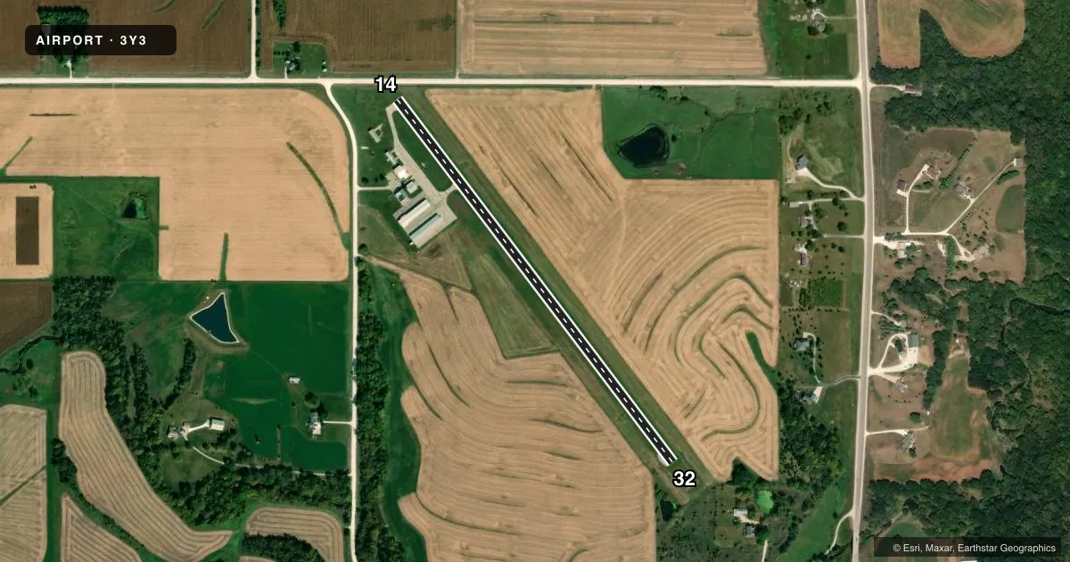
Airport sketch
Runways drawn to scale from FAA survey coordinates, rendered over satellite imagery. Not for navigation.
Approaches & charts
Services on the field
Fuel grades, oxygen, maintenance, ramp storage and lighting — as declared to the FAA by the airport operator.
Fuel & services
- Fuel
- 100LLA
- Oxygen (bottled)
- Not available
- Oxygen (bulk)
- Not available
- Airframe repair
- Major
- Power plant repair
- Major
- Other services
- INSTR,RNTL
Ramp & ground
- Transient storage
- Tie-down
- Hangar
- Landing fee
- No fee published
- Customs
- Not available
- Lighting schedule
- SEE RMK
- Beacon schedule
- SS-SR
- Beacon
- White / Green (civil land)(WG)
- Wind indicator
- Lighted
- Segmented circle
- No
Fuel & FBOs
Cheapest 100LL and Jet A on the field and nearby. Always confirm with the FBO before taxi.
Airport notes
Surface conditions, obstructions, local procedures, lighting outages and other notes published with each FAA cycle.
General notes
- ULTRALIGHT ACT ON & INVOF ARPT.
- RWY 32 END SAFETY AREA EXTDS 240 FT; SHARP DROP AT THAT POINT.
- INADQT CLNC FOR HLDG ON THE TARND AT THE THR OF RWY 32.
- RWY 32 IS CALM WIND RWY.
- FOR CD CTC DES MOINES ATCT AT 515-974-8016.
Lighting notes
- ACTVT MIRL RY 14/32 & PAPI RYS 14 & 32 - CTAF.
Runway surface & condition
- 14/32MIRL - RWY 14/32 ENDS HAVE SIX THLD LGTS AND ALL WHITE LENSES ALONG RWY LEN.
Approach & departure obstructions
- 1415 FT ROAD 140 FT FM RY END
- 14APCH SLOPE 6:1 FM DSPLCD THLD.
Other notes
- PRVDD NW END RWY IS DSPLCD SUF DSTC TO PRVD 15 FT CLNC OVR E/W RD FOR A 20:1 APCH RATIO.
- MANAGERWINTERSET.APMANAGER@GMAIL.COM
- OWNERWINTERSET AIRPORT AUTHORITY
VFR map & nearby airports
VFR sectional. Tap any ICAO chip to open that airport.
Key facts · 3Y3
Answer card- ICAO
- 3Y3
- Name
- WINTERSET MUNI
- Location
- WINTERSET, IOWA
- Elevation
- 1,115.5 ft MSL
- Traffic pattern altitude
- 1,915.5 ft MSL (800 AGL)
- Control tower
- Non-towered (use CTAF)
- Total runways
- 1
- Longest runway
- 14/32 · 3,002 ft
- Published ILS approaches
- 0
- Published frequencies
- 4
- Magnetic variation
- 2°
- Current flight rules
- VFR
- Current wind
- 230° at 11 kt
- Favored runway now
- RWY 14
Winterset Muni sits in Winterset, Iowa. The field elevation is 1,115.5 ft MSL. It has one runway, 14/32, which is 3,002 ft of asphalt. There is no control tower. Pattern altitude is 800 ft AGL, which is 1,915.5 ft MSL.
No ILS approaches are published here. The airport uses CTAF 122.7 and UNICOM 122.7. Des Moines Approach and Departure are on 123.9 and 360.7. XCL Aviation is on the field. It carries 100LL and Jet A. Call (515) 954-2600 for current service details.
A few runway notes matter here. Runway 32 is listed as the calm wind runway. The runway 32 safety area extends 240 ft past the end. There is a sharp drop there. There is also inadequate clearance for holding on the turnaround at the threshold of runway 32. Runway 14 has a displaced threshold because of road clearance. The approach slope from that displaced threshold is 6 to 1. Medium intensity runway lights are on runway 14/32. The PAPI on both ends is activated by CTAF. Ultralight traffic also operates on and near the airport. If you are new to the field, brief the runway ends carefully and verify current conditions with the airport operator or the FBO before arrival.