METAR & TAF 6Z6
6Z6 does not publish a METAR.
Showing the nearest reporting station: KDSM (DES MOINES INTL) · 14.5 NM away. Conditions at 6Z6 may differ.
METAR · KDSM
Observed 05:54Z
KDSM 270554Z 17006KT 10SM FEW120 29/25 A2982 RMK AO2 SLP087 T02940250 10344 20294 403610244 58002
- Wind
- 170° @ 6 kt
- Visibility
- 10 SM
- Temp / Dew
- 29°C / 25°C
- Altimeter
- 29.82 inHg
- Clouds
- FEW
- Density alt
- 3,033 ft
- Ceiling
- Unlimited
- Rules
- VFR
Airport info & contacts
Manager on record, flight service, ARTCC, attendance schedule and pattern altitude — published by the FAA and refreshed every 28 days.
Location
- From city
- 4 NM S
- VFR sectional
- OMAHA
- ARTCC
- ZMP · MINNEAPOLIS
- NOTAM facility
- FOD (NOTAM-D)
Airport manager
- Name
- NASH FIELD INC
- Phone
- 515-681-6455
- Address
- 12562 NEVADA ST, INDIANOLA IA 50125
Flight service · Hours
- FSS FOD
- FORT DODGE1-800-WX-BRIEF
- Attendance
- IREG
Frequencies
Tap any row to copy the frequency to your clipboard.
Runways & pattern
Full pagePattern entry · RWY 18
LEFT TRAFFICRunway end performance
| End | TORA | TODA | ASDA | LDA | VGSI | Approach lights | Obstruction |
|---|---|---|---|---|---|---|---|
| 18 | — | — | — | — | — | — | 10', road, 50' from thr, 0' R of cntrln, slope 5 |
Declared distances in feet. TORA = takeoff run available, TODA = takeoff distance, ASDA = accelerate-stop, LDA = landing distance.
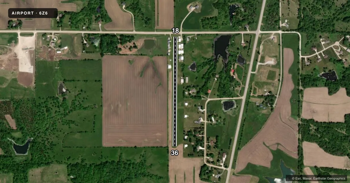
Airport sketch
Runways drawn to scale from FAA survey coordinates, rendered over satellite imagery. Not for navigation.
Approaches & charts
Services on the field
Fuel grades, oxygen, maintenance, ramp storage and lighting — as declared to the FAA by the airport operator.
Fuel & services
- Fuel
- Not available
- Airframe repair
- Not available
- Power plant repair
- Not available
Ramp & ground
- Transient storage
- Tie-down
- Landing fee
- No fee published
- Lighting schedule
- SEE RMK
- Wind indicator
- Yes
- Segmented circle
- No
Fuel & FBOs
Cheapest 100LL and Jet A on the field and nearby. Always confirm with the FBO before taxi.
Airport notes
Surface conditions, obstructions, local procedures, lighting outages and other notes published with each FAA cycle.
General notes
- NO ULTRA LIGHTS
- NO BALLOONS
- FOR CD CTC DES MOINES APPCH AT 515-974-8016
- ADTL CONTACT GREG AT 515-961-8227
Lighting notes
- ACTVT LIRL RY 18/36 - CTAF.
Runway surface & condition
- 18/36NSTD LIRL; THR LGTS RED/GREEN AT RY CORNERS AND CNTRLN.
Approach & departure obstructions
- 18TREES 75' TALL ON APCH TO RWY 18, 250' FROM RWY END.
VFR map & nearby airports
VFR sectional. Tap any ICAO chip to open that airport.
Key facts · 6Z6
Answer card- ICAO
- 6Z6
- Name
- NASH FLD INDIANOLA
- Location
- INDIANOLA, IOWA
- Elevation
- 991 ft MSL
- Traffic pattern altitude
- 1,991 ft MSL (1,000 AGL)
- Control tower
- Non-towered (use CTAF)
- Total runways
- 1
- Longest runway
- 18/36 · 2,215 ft
- Published ILS approaches
- 0
- Published frequencies
- 1
- Magnetic variation
- 4°
- Current flight rules
- VFR
- Current wind
- 170° at 6 kt
- Favored runway now
- RWY 18
NASH FLD INDIANOLA (6Z6) sits in Indianola, Iowa. The field elevation is 991 ft MSL. It has one runway. Runway 18/36 is 2,215 ft of turf, so plan for short-field performance and soft-field technique. There is no control tower. CTAF is 122.9.
No ILS approaches are published here. Pattern altitude is not published in the facts, so use the current FAA Chart Supplement before you fly. The published remarks also matter. Trees 75 ft tall sit on the approach to runway 18 about 250 ft from the runway end. That makes the south end worth a close look on arrival and departure. Low intensity runway lights are nonstandard. They are activated via CTAF. Threshold lights are red and green at the runway corners and centerline.
There are no on-field FBOs listed in the facts. Contact the airport operator directly or call the field for current service details before arrival. The published remarks also say no balloons and no ultralights are permitted. For clearance delivery, contact Des Moines Approach at 515-974-8016. If you are new to the field, review the current Chart Supplement and plan conservatively for the turf surface. Also plan for the tree obstruction near runway 18. The lighting setup at night deserves a close check.