METAR & TAF KCNC
Current METAR
Observed 13:35Z
KCNC 271335Z AUTO 19008KT 10SM FEW100 A2978 RMK AO2
- Wind
- 190° @ 8 kt
- Visibility
- 10 SM
- Temp / Dew
- —
- Altimeter
- 29.78 inHg
- Clouds
- FEW
- Density alt
- —
- Ceiling
- Unlimited
- Rules
- VFR
Airport info & contacts
Manager on record, flight service, ARTCC, attendance schedule and pattern altitude — published by the FAA and refreshed every 28 days.
Location
- From city
- 3 NM W
- VFR sectional
- OMAHA
- ARTCC
- ZMP · MINNEAPOLIS
- NOTAM facility
- CNC (NOTAM-D)
Airport manager
- Name
- CHRISTY METZGER
- Phone
- 641-774-5991
- Address
- 115 SOUTH MAIN, CHARITON IA 50049
Flight service · Hours
- FSS FOD
- FORT DODGE1-800-WX-BRIEF
- Attendance
- ON CALL
Frequencies
Tap any row to copy the frequency to your clipboard.
Runways & pattern
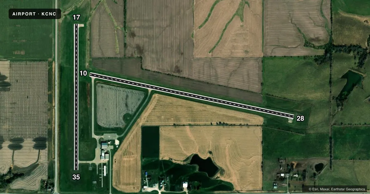
Full pagePattern entry · RWY 17
LEFT TRAFFIC| Runway | Heading (°M) | Length | Surface | Traffic |
|---|---|---|---|---|
| 10/28 | 99° / 279° | 4,000 ft | CONC | Standard L |
| 17/35Favored | 177° / 357° | 2,800 ft | CONC | Standard L |
Runway end performance
| End | TORA | TODA | ASDA | LDA | VGSI | Approach lights | Obstruction |
|---|---|---|---|---|---|---|---|
| 10 | — | — | — | — | VASI 2-box left(3°) | — | — |
| 28 | — | — | — | — | PAPI 2-box left(3°) | — | 21', tree, 948' from thr, 31' R of cntrln, slope 35 |
| 17 | — | — | — | — | PAPI 2-box left | — | — |
| 35 | — | — | — | — | PAPI 2-box left | — | 15', road, 500' from thr, 0' R of cntrln, slope 20 |
Declared distances in feet. TORA = takeoff run available, TODA = takeoff distance, ASDA = accelerate-stop, LDA = landing distance.
Airport sketch
Runways drawn to scale from FAA survey coordinates, rendered over satellite imagery. Not for navigation.
Approaches & charts
Services on the field
Fuel grades, oxygen, maintenance, ramp storage and lighting — as declared to the FAA by the airport operator.
Fuel & services
- Fuel
- 100LL
- Oxygen (bottled)
- Not available
- Oxygen (bulk)
- Not available
- Airframe repair
- Not available
- Power plant repair
- Not available
Ramp & ground
- Transient storage
- Hangar
- Landing fee
- No fee published
- Customs
- Not available
- Lighting schedule
- SEE RMK
- Beacon schedule
- SS-SR
- Beacon
- White / Green (civil land)(WG)
- Wind indicator
- Lighted
- Segmented circle
- Yes
Fuel & FBOs
Cheapest 100LL and Jet A on the field and nearby. Always confirm with the FBO before taxi.
Airport notes
Surface conditions, obstructions, local procedures, lighting outages and other notes published with each FAA cycle.
General notes
- FOR CD CTC DES MOINES ATCT AT 515-974- 8016.
Lighting notes
- MIRL RYS 17/35 & 10/28 PRESET ON LOW INTST; TO INCR INTST & ACTVT REIL RYS 17; 35; 10 & 28; PAPI RYS 17; 35 & 28 - CTAF.
Approach & departure obstructions
- 10+18' ROAD AT 650' GLIDESLOPE 25:1.
Other notes
- 4FOR ASSISTANCE CALL 641-774-5083.
VFR map & nearby airports
VFR sectional. Tap any ICAO chip to open that airport.
Key facts · KCNC
Answer card- ICAO
- KCNC
- Name
- CHARITON MUNI
- Location
- CHARITON, IOWA
- Elevation
- 1,050.5 ft MSL
- Traffic pattern altitude
- 2,050.5 ft MSL (1,000 AGL)
- Control tower
- Non-towered (use CTAF)
- Total runways
- 2
- Longest runway
- 10/28 · 4,000 ft
- Published ILS approaches
- 0
- Published frequencies
- 4
- Magnetic variation
- 3°
- Current flight rules
- VFR
- Current wind
- 190° at 8 kt
- Favored runway now
- RWY 17
Chariton Muni sits in Chariton, Iowa. Field elevation is 1,050.5 ft MSL. The airport has two concrete runways. The longest is runway 10/28 at 4,000 ft. Runway 17/35 is 2,800 ft. There is no control tower, so plan to self-announce on CTAF 122.8. No ILS approaches are published here.
Pattern altitude is not published. Use the standard 1,000 ft AGL for light piston operations unless the current Chart Supplement says otherwise. That puts the normal pattern reference at about 2,050.5 ft MSL based on the field elevation. The field uses Des Moines approach frequencies for IFR support. Clearance delivery is handled through Des Moines Air Traffic Control Tower by phone. If you need help on the ground, the published assistance number is also listed in the Chart Supplement remarks.
The on-field FBO is Chariton Municipal Airport. It carries 100LL and Jet A. Runway lighting is preset to low intensity. Use the CTAF to increase intensity and to activate runway end identifier lights. PAPI is available on runways 17, 35 and 28. Watch the published obstruction note near runway 10. There is an 18-foot road about 650 feet from the glideslope with a 25:1 clearance slope. That makes a careful approach setup smart, especially if you are arriving at night or in marginal visibility.