METAR & TAF K43
K43 does not publish a METAR.
Showing the nearest reporting station: KTVK (CENTERVILLE MUNI) · 10.4 NM away. Conditions at K43 may differ.
METAR · KTVK
Observed 13:15Z
KTVK 271315Z AUTO 20007KT 10SM CLR 28/25 A2983 RMK A01
- Wind
- 200° @ 7 kt
- Visibility
- 10 SM
- Temp / Dew
- 28°C / 25°C
- Altimeter
- 29.83 inHg
- Clouds
- CLR
- Density alt
- 2,967 ft
- Ceiling
- Unlimited
- Rules
- VFR
Airport info & contacts
Manager on record, flight service, ARTCC, attendance schedule and pattern altitude — published by the FAA and refreshed every 28 days.
Location
- From city
- 3 NM N
- VFR sectional
- OMAHA
- ARTCC
- ZKC · KANSAS CITY
- NOTAM facility
- COU (NOTAM-D)
Airport manager
- Name
- CITY HALL
- Phone
- 660-947-2437
- Address
- 1611 GRANT ST, PO BOX 255, UNIONVILLE MO 63565
Flight service · Hours
- FSS COU
- COLUMBIA1-800-WX-BRIEF
- Attendance
- Unattended
Frequencies
Tap any row to copy the frequency to your clipboard.
Runways & pattern
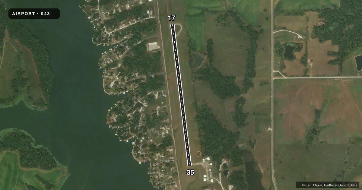
Full pagePattern entry · RWY 17
LEFT TRAFFICAirport sketch
Runways drawn to scale from FAA survey coordinates, rendered over satellite imagery. Not for navigation.
Approaches & charts
Services on the field
Fuel grades, oxygen, maintenance, ramp storage and lighting — as declared to the FAA by the airport operator.
Fuel & services
- Fuel
- Not available
- Oxygen (bottled)
- Not available
- Oxygen (bulk)
- Not available
- Power plant repair
- Not available
Ramp & ground
- Transient storage
- Tie-down
- Landing fee
- No fee published
- Customs
- Not available
- Lighting schedule
- SEE RMK
- Beacon schedule
- SEE RMK
- Beacon
- White / Green (civil land)(WG)
- Wind indicator
- Lighted
- Segmented circle
- Yes
Fuel & FBOs
Cheapest 100LL and Jet A on the field and nearby. Always confirm with the FBO before taxi.
Airport notes
Surface conditions, obstructions, local procedures, lighting outages and other notes published with each FAA cycle.
General notes
- FOR CD CTC KANSAS CITY ARTCC AT 913-254-8508.
Lighting notes
- DUSK-2300. ACTVT ROTG BCN - CTAF; 3 CLICKS ON & 2 CLICKS OFF.
- ACTVT LIRL RY 17/35- CTAF; 3 CLICKS ON & 2 CLICKS OFF.
Runway surface & condition
- 17/35WIDTH VARIANCE 49-50 FT.
Other notes
- OVERNIGHT TIEDOWN FEE.
VFR map & nearby airports
VFR sectional. Tap any ICAO chip to open that airport.
Key facts · K43
Answer card- ICAO
- K43
- Name
- UNIONVILLE MUNI
- Location
- UNIONVILLE, MISSOURI
- Elevation
- 1,045 ft MSL
- Traffic pattern altitude
- 2,045 ft MSL (1,000 AGL)
- Control tower
- Non-towered (use CTAF)
- Total runways
- 1
- Longest runway
- 17/35 · 2,805 ft
- Published ILS approaches
- 0
- Published frequencies
- 1
- Magnetic variation
- 4°
- Current flight rules
- VFR
- Current wind
- 200° at 7 kt
- Favored runway now
- RWY 17
Unionville Muni sits in Unionville, Missouri. The field elevation is 1,045 ft MSL. It has one runway. Runway 17/35 is 2,805 ft of asphalt, so plan your performance with the short field in mind. The airport is non-towered. CTAF is 122.9. No ILS approaches are published here.
Pattern altitude is not published. Use the standard 1,000 ft AGL for light piston operations unless the current Chart Supplement says otherwise. The rotating beacon is active from dusk to 2300. The runway lights on 17/35 can be turned on from CTAF with microphone clicks. Clearance delivery is handled through Kansas City ARTCC at 913-254-8508.
There are no on-field FBOs listed. Plan fuel and services accordingly. The published remarks also note an overnight tiedown fee. Runway 17/35 width varies between 49 and 50 feet. Keep that in mind on rollout and taxi. For a first-time arrival, the main items are the short runway, the non-towered pattern and the lighting activation procedure. Check the current Chart Supplement before departure for any updated remarks or local procedures.