METAR & TAF 5MO
5MO does not publish a METAR.
Showing the nearest reporting station: KIRK (KIRKSVILLE RGNL) · 17.9 NM away. Conditions at 5MO may differ.
METAR · KIRK
Observed 15:55Z
KIRK 271555Z AUTO 20008KT 10SM SCT100 29/24 A2984 RMK AO2 SLP097 T02890239 TSNO $
- Wind
- 200° @ 8 kt
- Visibility
- 10 SM
- Temp / Dew
- 29°C / 24°C
- Altimeter
- 29.84 inHg
- Clouds
- SCT
- Density alt
- 3,018 ft
- Ceiling
- Unlimited
- Rules
- VFR
Airport info & contacts
Manager on record, flight service, ARTCC, attendance schedule and pattern altitude — published by the FAA and refreshed every 28 days.
Location
- From city
- 1 NM S
- VFR sectional
- CHICAGO
- ARTCC
- ZKC · KANSAS CITY
- NOTAM facility
- COU
Airport manager
- Name
- PAUL APPLEGATE
- Phone
- 660-766-2644
- Address
- 18403 W. LONE PINE DR., QUEEN CITY MO 63561
Flight service · Hours
- FSS COU
- COLUMBIA1-800-WX-BRIEF
- Attendance
- ALL
Frequencies
Tap any row to copy the frequency to your clipboard.
Runways & pattern
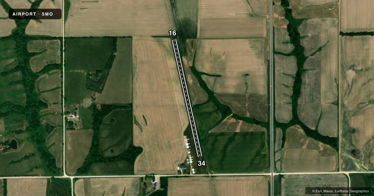
Full pagePattern entry · RWY 16
RIGHT TRAFFICAirport sketch
Runways drawn to scale from FAA survey coordinates, rendered over satellite imagery. Not for navigation.
Approaches & charts
Services on the field
Fuel grades, oxygen, maintenance, ramp storage and lighting — as declared to the FAA by the airport operator.
Fuel & services
- Fuel
- Not available
- Airframe repair
- Not available
- Power plant repair
- Not available
Ramp & ground
- Transient storage
- Tie-down
- Landing fee
- No fee published
- Lighting schedule
- SS-SR
- Beacon schedule
- SS-SR
- Beacon
- White / Green (civil land)(WG)
- Wind indicator
- Yes
- Segmented circle
- No
Fuel & FBOs
Cheapest 100LL and Jet A on the field and nearby. Always confirm with the FBO before taxi.
Airport notes
Surface conditions, obstructions, local procedures, lighting outages and other notes published with each FAA cycle.
General notes
- FOR CD CTC KANSAS CITY ARTCC AT 913-254-8508.
Runway surface & condition
- 16/34NSTD LIRL 2 RED THR LGTS BOTH ENDS; RY 16 THR 2 GREEN/RED LGTS 185 FT SOUTHEAST OF THR; RY 34 THR 2 GREEN/RED LGTS 195 FT NORTHWEST OF THR.
Approach & departure obstructions
- 1616/34 MARKED WITH TIRES.
Other notes
- CONDL PROVIDED APCH TO EACH RWY IS MAINTAINED FOR A MIN 20-1 GLIDE SLOPE AND TRANSITIONAL SURFACE BE MAINTAINED FOR A 7-1 SLOPE.
- 1MGR LIVES ON ARPT.
- MANAGERWORK PHONE 660-988-2967 CALL FOR RWY CONDS.
VFR map & nearby airports
VFR sectional. Tap any ICAO chip to open that airport.
Key facts · 5MO
Answer card- ICAO
- 5MO
- Name
- APPLEGATE
- Location
- QUEEN CITY, MISSOURI
- Elevation
- 999 ft MSL
- Traffic pattern altitude
- 1,999 ft MSL (1,000 AGL)
- Control tower
- Non-towered (use CTAF)
- Total runways
- 1
- Longest runway
- 16/34 · 2,295 ft
- Published ILS approaches
- 0
- Published frequencies
- 1
- Magnetic variation
- 3°
- Current flight rules
- VFR
- Current wind
- 200° at 8 kt
- Favored runway now
- RWY 16
Applegate Airport sits near Queen City, Missouri. Field elevation is 999 ft MSL. It has one runway. The longest is runway 16/34 at 2,295 ft of turf. There is no control tower. CTAF is 122.9. No ILS approaches are published here.
The pattern altitude is not published. Use the standard 1,000 ft AGL for light piston operations unless the current Chart Supplement says otherwise. With a 999 ft field elevation, that puts the usual light aircraft pattern near 1,999 ft MSL. Runway headings are magnetic. Runway 16 is marked with tires. Runway 34 is marked with tires too. The runway also has nonstandard low intensity lights with red threshold lights at both ends. That is useful if you are planning a night arrival.
There are no on-field FBOs listed. Call the airport manager at 660-988-2967 for runway conditions before you go. The manager lives on the airport. Published remarks also note that clearance delivery goes through Kansas City ARTCC at 913-254-8508. This is a small turf field, so check surface condition carefully. Verify the current Chart Supplement before flying in if you need any current operational detail.