METAR & TAF 03D
03D does not publish a METAR.
Showing the nearest reporting station: KIRK (KIRKSVILLE RGNL) · 25.8 NM away. Conditions at 03D may differ.
METAR · KIRK
Observed 11:55Z
KIRK 271155Z AUTO 20005KT 10SM CLR 26/23 A2986 RMK AO2 SLP105 T02560233 10267 20250 50003 TSNO $
- Wind
- 200° @ 5 kt
- Visibility
- 10 SM
- Temp / Dew
- 26°C / 23°C
- Altimeter
- 29.86 inHg
- Clouds
- CLR
- Density alt
- 2,403 ft
- Ceiling
- Unlimited
- Rules
- VFR
Airport info & contacts
Manager on record, flight service, ARTCC, attendance schedule and pattern altitude — published by the FAA and refreshed every 28 days.
Location
- From city
- 3 NM SW
- VFR sectional
- CHICAGO
- ARTCC
- ZKC · KANSAS CITY
- NOTAM facility
- COU (NOTAM-D)
Airport manager
- Name
- REGINA LONG
- Phone
- 660-465-7285
- Address
- 125 WEST JEFFERSON STREET, MEMPHIS MO 63555
Flight service · Hours
- FSS COU
- COLUMBIA1-800-WX-BRIEF
- Attendance
- Unattended
Frequencies
Tap any row to copy the frequency to your clipboard.
Runways & pattern
Full pagePattern entry · RWY 12
LEFT TRAFFICRunway end performance
| End | TORA | TODA | ASDA | LDA | VGSI | Approach lights | Obstruction |
|---|---|---|---|---|---|---|---|
| 12 | — | — | — | — | PAPI 2-box left(3°) | — | — |
| 30 | — | — | — | — | PAPI 2-box left(3°) | — | — |
Declared distances in feet. TORA = takeoff run available, TODA = takeoff distance, ASDA = accelerate-stop, LDA = landing distance.
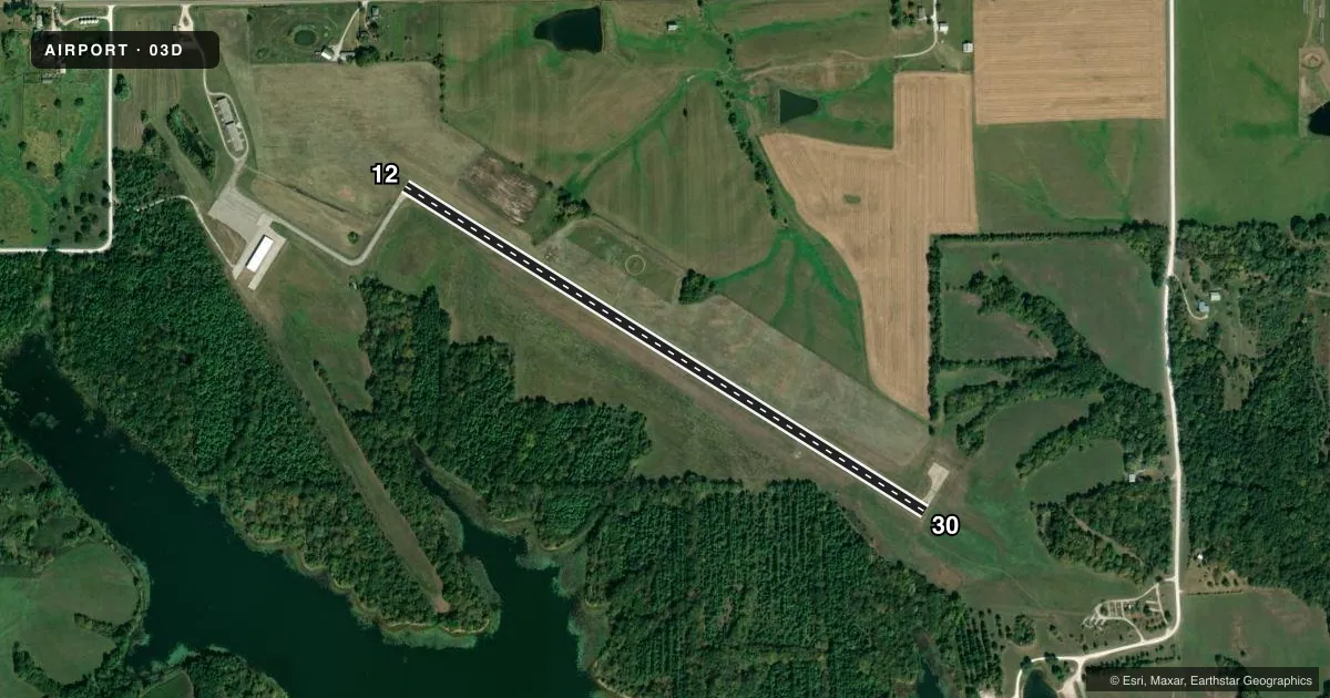
Airport sketch
Runways drawn to scale from FAA survey coordinates, rendered over satellite imagery. Not for navigation.
Approaches & charts
Services on the field
Fuel grades, oxygen, maintenance, ramp storage and lighting — as declared to the FAA by the airport operator.
Fuel & services
- Fuel
- 100LL
- Oxygen (bottled)
- Not available
- Oxygen (bulk)
- Not available
- Other services
- INSTR,RNTL
Ramp & ground
- Transient storage
- Tie-down
- Landing fee
- No fee published
- Customs
- Not available
- Lighting schedule
- SEE RMK
- Beacon schedule
- SS-SR
- Beacon
- White / Green (civil land)(WG)
- Wind indicator
- Lighted
- Segmented circle
- Yes
Fuel & FBOs
Cheapest 100LL and Jet A on the field and nearby. Always confirm with the FBO before taxi.
Airport notes
Surface conditions, obstructions, local procedures, lighting outages and other notes published with each FAA cycle.
General notes
- RADIO CONTROLLED MODEL PLANES ON & INVOF ARPT.
- FOR CD CTC KANSAS CITY ARTCC AT 913-254-8508.
Lighting notes
- PAPI RWY 12 AND 30; MIRL RWY 12/30 OPER DUSK TO 0100. TO ACTVT AND INCR INTST - CTAF.
Fuel notes
- 100LLFOR FUEL CALL (660) 465-2611.
Other notes
- PROVIDED APCH TO EACH RWY IS MAINTAINED FOR A MIN 20:1 GLIDE SLOPE AND THE TRANSITIONAL SURFACE BE MAINTAINED FOR A 7:1 SLOPE.
- MANAGERARPT COMMITTEE CHAIRMAN.
VFR map & nearby airports
VFR sectional. Tap any ICAO chip to open that airport.
Key facts · 03D
Answer card- ICAO
- 03D
- Name
- MEMPHIS MEML
- Location
- MEMPHIS, MISSOURI
- Elevation
- 813.3 ft MSL
- Traffic pattern altitude
- 1,813.3 ft MSL (1,000 AGL)
- Control tower
- Non-towered (use CTAF)
- Total runways
- 1
- Longest runway
- 12/30 · 3,300 ft
- Published ILS approaches
- 0
- Published frequencies
- 1
- Magnetic variation
- 3°
- Current flight rules
- VFR
- Current wind
- 200° at 5 kt
- Favored runway now
- RWY 12
Memphis Memorial Airport sits in Memphis, Missouri. The field elevation is 813.3 ft MSL. It has one runway. Runway 12/30 is 3,300 ft long with a concrete surface. There is no control tower. CTAF is 122.9.
No ILS approaches are published here. The pattern altitude is not published in the facts, so plan on the standard 1,000 ft AGL unless the current FAA Chart Supplement says otherwise. PAPI is available on both runway ends. Medium intensity runway lights are also available on 12 and 30. They operate from dusk to 0100. Use the CTAF to activate them. Use it to increase intensity.
Memphis Memorial Airport is on the field and carries 100LL. Call the airport first for fuel at (660) 465-2611. For a direct airport contact, the listed phone is (660) 465-7285. Clearance delivery is handled through Kansas City ARTCC at 913-254-8508. One operational note matters here. Radio controlled model planes operate on and near the airport, so keep your scan sharp in the pattern and on final. The runway approach surfaces are maintained to published glide slope standards, so expect a field that is kept to a defined approach profile.