METAR & TAF 0H7
0H7 does not publish a METAR.
Showing the nearest reporting station: KEOK (KEOKUK MUNI) · 12.9 NM away. Conditions at 0H7 may differ.
METAR · KEOK
Observed 20:55Z
KEOK 262055Z AUTO 00000KT 10SM CLR 36/27 A2986 RMK A01
- Wind
- 000° @ 0 kt
- Visibility
- 10 SM
- Temp / Dew
- 36°C / 27°C
- Altimeter
- 29.86 inHg
- Clouds
- CLR
- Density alt
- 3,462 ft
- Ceiling
- Unlimited
- Rules
- VFR
Airport info & contacts
Manager on record, flight service, ARTCC, attendance schedule and pattern altitude — published by the FAA and refreshed every 28 days.
Location
- From city
- 1 NM E
- VFR sectional
- CHICAGO
- ARTCC
- ZKC · KANSAS CITY
- NOTAM facility
- COU (NOTAM-D)
Airport manager
- Name
- JIM SHERWOOD
- Phone
- 660-727-2512
- Address
- 250 N MORGAN, KAHOKA MO 63445
Flight service · Hours
- FSS COU
- COLUMBIA1-800-WX-BRIEF
- Attendance
- Unattended
Frequencies
Tap any row to copy the frequency to your clipboard.
Runways & pattern
Full pagePattern entry · RWY 10
LEFT TRAFFICRunway end performance
| End | TORA | TODA | ASDA | LDA | VGSI | Approach lights | Obstruction |
|---|---|---|---|---|---|---|---|
| 10 | — | — | — | — | — | — | 16', road, 26' from thr, 0' R of cntrln, slope 1 |
| 28 | — | — | — | — | — | — | 15', road, 14' from thr, 0' R of cntrln, slope 0 |
Declared distances in feet. TORA = takeoff run available, TODA = takeoff distance, ASDA = accelerate-stop, LDA = landing distance.
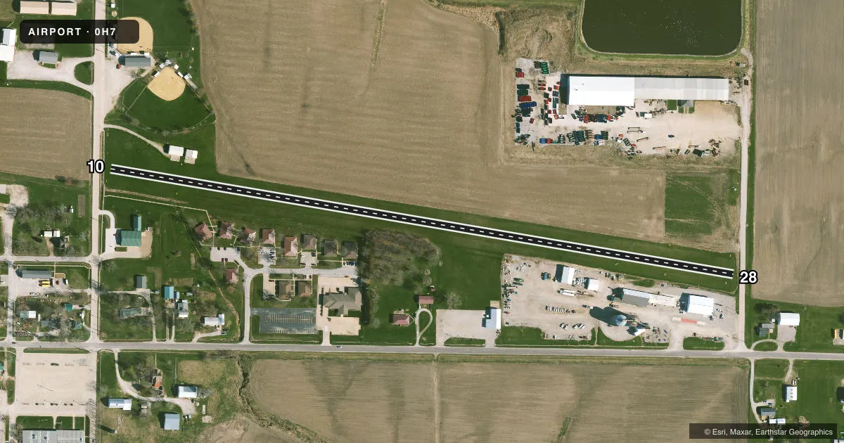
Airport sketch
Runways drawn to scale from FAA survey coordinates, rendered over satellite imagery. Not for navigation.
Approaches & charts
Services on the field
Fuel grades, oxygen, maintenance, ramp storage and lighting — as declared to the FAA by the airport operator.
Fuel & services
- Fuel
- Not available
- Oxygen (bottled)
- Not available
- Oxygen (bulk)
- Not available
- Power plant repair
- Not available
Ramp & ground
- Transient storage
- Not published
- Landing fee
- No fee published
- Customs
- Not available
- Wind indicator
- Yes
- Segmented circle
- No
Fuel & FBOs
Cheapest 100LL and Jet A on the field and nearby. Always confirm with the FBO before taxi.
Airport notes
Surface conditions, obstructions, local procedures, lighting outages and other notes published with each FAA cycle.
General notes
- NMRS TALL OBJECTS WI TRSNL SFC ALG THE ENTR SOUTH EDGE OF THE RWY.
- RWY 10/28 SOFT AFT HEAVY RAINS. CALL 660-727-3711 FOR RWY CONDS.
- BE ALERT DURING SPRING AND SUMMER MONTHS DUE TO FARM IRRIGATION SYSTEM ALONG NORTH RWY EDGE.
- WILDLIFE ON & INVOF ARPT.
- FOR CD CTC KANSAS CITY ARTCC AT 913-254-8508.
Approach & departure obstructions
- 10DSPLCD THLD MKD WITH THREE LARGE YELLOW CONES ON EACH SIDE OF RY.
- 28DSPLCD THLD MKD WITH THREE LARGE YELLOW CONES ON EACH SIDE OF RY.
- 10APCH SLOPE 17:1 TO DSPLCD THLD; +34 FT TREE, 150 FT FM RY END, 80 FT R
- 28APCH SLOPE 13:1 BSD ON DSPLCD THLD; +45 FT TREES, 575 FT TO 700 FT FM RY END, 150 FT L AND RT
Other notes
- EXISTED PRIOR TO 1959.
- 10/28FM RY 28 THLD TO 800 FT W S EDGE OF RY 1-2 FT HIGHER THAN N EDGE.
VFR map & nearby airports
VFR sectional. Tap any ICAO chip to open that airport.
Key facts · 0H7
Answer card- ICAO
- 0H7
- Name
- KAHOKA MUNI
- Location
- KAHOKA, MISSOURI
- Elevation
- 700 ft MSL
- Traffic pattern altitude
- 1,700 ft MSL (1,000 AGL)
- Control tower
- Non-towered (use CTAF)
- Total runways
- 1
- Longest runway
- 10/28 · 2,680 ft
- Published ILS approaches
- 0
- Published frequencies
- 1
- Magnetic variation
- 3°
- Current flight rules
- VFR
- Current wind
- 000° at 0 kt
- Favored runway now
- –
Kahoka Muni is in Kahoka, Missouri. The field elevation is 700 ft MSL. It has one runway. The longest runway is 2,680 ft of turf. There is no control tower. CTAF is 122.9.
No ILS approaches are published here. Pattern altitude is not published, so use the standard 1,000 ft AGL unless the current Chart Supplement says otherwise. The runway is soft after heavy rains. Call 660-727-3711 for runway conditions before you go. Wildlife is reported on and near the airport. Spring and summer can also bring irrigation equipment along the north edge of the runway.
Runway 10 and runway 28 both have displaced thresholds marked with large yellow cones. The published remarks also note trees near both ends. Runway 28 has 45-foot trees near the approach path. Runway 10 has a 34-foot tree near the end of the runway. There are also tall objects along the south edge of the runway. Clearance delivery is handled through Kansas City ARTCC at 913-254-8508. For a first visit, plan for a turf strip with no tower, no published ILS and some terrain and obstruction awareness on short final.