METAR & TAF KHAE
Current METAR
Observed 13:35Z
KHAE 271335Z AUTO 20005KT 10SM CLR 30/24 A2989 RMK AO2
- Wind
- 200° @ 5 kt
- Visibility
- 10 SM
- Temp / Dew
- 30°C / 24°C
- Altimeter
- 29.89 inHg
- Clouds
- CLR
- Density alt
- 2,791 ft
- Ceiling
- Unlimited
- Rules
- VFR
Airport info & contacts
Manager on record, flight service, ARTCC, attendance schedule and pattern altitude — published by the FAA and refreshed every 28 days.
Location
- From city
- 4 NM NW
- VFR sectional
- KANSAS CITY
- ARTCC
- ZKC · KANSAS CITY
- NOTAM facility
- STL (NOTAM-D)
Airport manager
- Name
- ANDY DORIAN
- Phone
- 573-406-3728
- Address
- CITY OF HANNIBAL, 6079 COUNTY ROAD 425, HANNIBAL MO 63401
Flight service · Hours
- FSS STL
- SAINT LOUIS1-800-WX-BRIEF
- Attendance
- 0800-DUSK
Frequencies
Tap any row to copy the frequency to your clipboard.
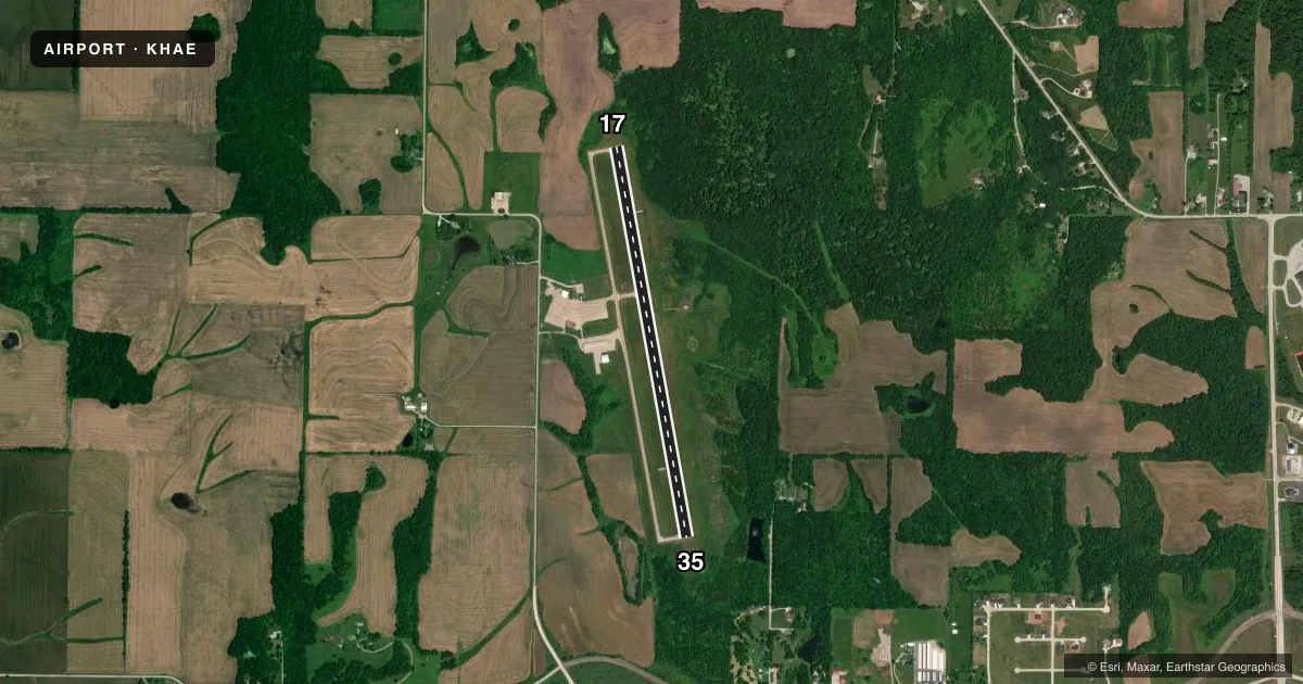
Runways & pattern
Full pagePattern entry · RWY 17
LEFT TRAFFICRunway end performance
| End | TORA | TODA | ASDA | LDA | VGSI | Approach lights | Obstruction |
|---|---|---|---|---|---|---|---|
| 17 | — | — | — | — | PAPI 4-box left(3°) | — | — |
| 35 | — | — | — | — | PAPI 4-box left(3°) | — | 55', trees, 1285' from thr, 415' R of cntrln, slope 19 |
Declared distances in feet. TORA = takeoff run available, TODA = takeoff distance, ASDA = accelerate-stop, LDA = landing distance.
Airport sketch
Runways drawn to scale from FAA survey coordinates, rendered over satellite imagery. Not for navigation.
Approaches & charts
Services on the field
Fuel grades, oxygen, maintenance, ramp storage and lighting — as declared to the FAA by the airport operator.
Fuel & services
- Fuel
- 100LLA
- Oxygen (bottled)
- Not available
- Oxygen (bulk)
- Not available
- Airframe repair
- Major
- Power plant repair
- Major
- Other services
- GLD,INSTR,RNTL,SALES,TOW
Ramp & ground
- Transient storage
- Tie-down
- Hangar
- Landing fee
- No fee published
- Customs
- Not available
- Lighting schedule
- SEE RMK
- Beacon schedule
- SS-SR
- Beacon
- White / Green (civil land)(WG)
- Wind indicator
- Lighted
- Segmented circle
- Yes
Fuel & FBOs
Cheapest 100LL and Jet A on the field and nearby. Always confirm with the FBO before taxi.
Airport notes
Surface conditions, obstructions, local procedures, lighting outages and other notes published with each FAA cycle.
General notes
- MAINTAIN CLEAR OF HOSPITAL AREA WHEN DEPARTING RWY 17.
- GLIDER ACTIVITY ON ARPT.
- DEER INVOF MOVEMENT AREAS.
- FOR CD CTC KANSAS CITY ARTCC AT 913-254-8508.
Lighting notes
- ACTVT REIL RWY 17 AND 35; MIRL RWY 17/35 - CTAF. PAPI RWY 17 AND 35 OPR CONSLY.
VFR map & nearby airports
VFR sectional. Tap any ICAO chip to open that airport.
Key facts · KHAE
Answer card- ICAO
- KHAE
- Name
- HANNIBAL RGNL
- Location
- HANNIBAL, MISSOURI
- Elevation
- 768.9 ft MSL
- Traffic pattern altitude
- 1,768.9 ft MSL (1,000 AGL)
- Control tower
- Non-towered (use CTAF)
- Total runways
- 1
- Longest runway
- 17/35 · 4,400 ft
- Published ILS approaches
- 0
- Published frequencies
- 2
- Magnetic variation
- 0°
- Current flight rules
- VFR
- Current wind
- 200° at 5 kt
- Favored runway now
- RWY 17
Hannibal Rgnl sits in Hannibal, Missouri. The field elevation is 768.9 ft MSL. It has one runway, 17/35, which is 4,400 ft long and paved with concrete. There is no control tower. CTAF and UNICOM are both 122.8. No ILS approaches are published here.
The published pattern altitude is not listed, so use the standard 1,000 ft AGL pattern unless the current Chart Supplement says otherwise. That puts the light piston pattern at about 1,769 ft MSL based on the field elevation. Hannibal Regional Airport is the on-field FBO. It carries 100LL and Jet A. Call them at (573) 406-3728 for current service details.
A few local items matter here. Runway end identifier lights are available on 17 and 35. Medium intensity runway lights are controlled by CTAF. The PAPI on both runway ends operates continuously. Glider activity occurs on the airport. Keep clear of the hospital area when departing runway 17. Deer are reported in the movement area vicinity. Plan for wildlife scanning on taxi, takeoff and landing. If you need clearance delivery, contact Kansas City ARTCC at 913-254-8508 before departure.