METAR & TAF K52
K52 does not publish a METAR.
Showing the nearest reporting station: KHAE (HANNIBAL RGNL) · 14.2 NM away. Conditions at K52 may differ.
METAR · KHAE
Observed 09:35Z
KHAE 270935Z AUTO 22004KT 10SM CLR 27/25 A2986 RMK AO2
- Wind
- 220° @ 4 kt
- Visibility
- 10 SM
- Temp / Dew
- 27°C / 25°C
- Altimeter
- 29.86 inHg
- Clouds
- CLR
- Density alt
- 2,428 ft
- Ceiling
- Unlimited
- Rules
- VFR
Airport info & contacts
Manager on record, flight service, ARTCC, attendance schedule and pattern altitude — published by the FAA and refreshed every 28 days.
Location
- From city
- 1 NM S
- VFR sectional
- KANSAS CITY
- Pattern altitude
- 965 ft AGL · 1,702 ft MSL
- ARTCC
- ZKC · KANSAS CITY
- NOTAM facility
- STL (NOTAM-D)
Airport manager
- Name
- DELL BUCKMAN
- Phone
- 573-231-9521
- Address
- 109 2ND ST., BOX 67, MONROE CITY MO 63456
Flight service · Hours
- FSS STL
- SAINT LOUIS1-800-WX-BRIEF
- Attendance
- MON-FRI · 0800-1700
- SAT · 0800-1200
Frequencies
Tap any row to copy the frequency to your clipboard.
Runways & pattern
Full pagePattern entry · RWY 27
LEFT TRAFFICRunway end performance
| End | TORA | TODA | ASDA | LDA | VGSI | Approach lights | Obstruction |
|---|---|---|---|---|---|---|---|
| 09 | — | — | — | — | PAPI 2-box left(3°) | — | 20', pole, 495' from thr, 145' R of cntrln, slope 14 |
| 27 | — | — | — | — | PAPI 2-box left(3°) | — | 21', trees, 425' from thr, 125' R of cntrln, slope 10 |
Declared distances in feet. TORA = takeoff run available, TODA = takeoff distance, ASDA = accelerate-stop, LDA = landing distance.
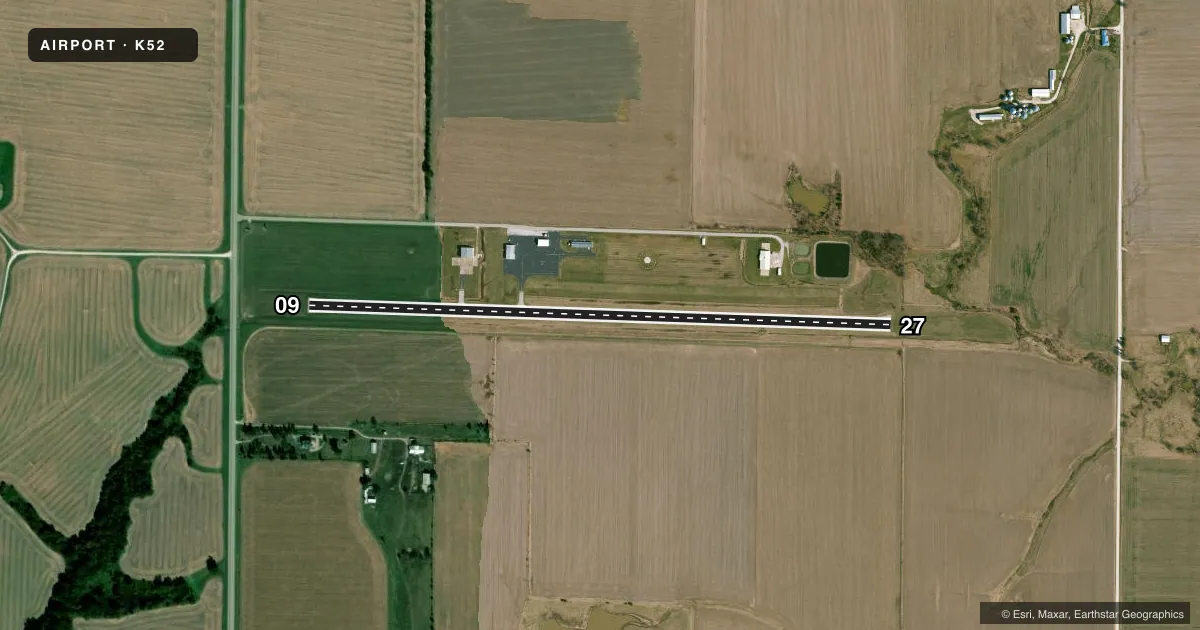
Airport sketch
Runways drawn to scale from FAA survey coordinates, rendered over satellite imagery. Not for navigation.
Approaches & charts
Services on the field
Fuel grades, oxygen, maintenance, ramp storage and lighting — as declared to the FAA by the airport operator.
Fuel & services
- Fuel
- 100LL
- Oxygen (bottled)
- Not available
- Oxygen (bulk)
- Not available
Ramp & ground
- Transient storage
- Tie-down
- Landing fee
- No fee published
- Customs
- Not available
- Lighting schedule
- SEE RMK
- Beacon schedule
- SS-SR
- Beacon
- White / Green (civil land)(WG)
- Wind indicator
- Lighted
- Segmented circle
- Yes
Fuel & FBOs
Cheapest 100LL and Jet A on the field and nearby. Always confirm with the FBO before taxi.
Airport notes
Surface conditions, obstructions, local procedures, lighting outages and other notes published with each FAA cycle.
General notes
- FOR CD CTC KANSAS CITY ARTCC AT 913-254-8508.
Lighting notes
- DUSK-DAWN. MIRL RY 09/27 PRESET LOW INTST; TO INCR INTST & ACTVT PAPI RYS 09 & 27 - CTAF.
Approach & departure obstructions
- 09+1-4' FENCE 0-200' FM RY END 120'R.
- 271-5 FT FENCE 65-200 FT FM RY END & 120 FT R; 1-5 FT FENCE 0-200 FT FM RY END & 125 FT L.
Other notes
- THIS AIRPORT HAS BEEN SURVEYED BY THE NATIONAL GEODETIC SURVEY.
- TPA LIGHT ACFT 800 FT AGL, TURBO PROP AND JETS 1500 FT AGL
- MANAGERAIRPORT OFFICE PHONE (573) 735-4845.
VFR map & nearby airports
VFR sectional. Tap any ICAO chip to open that airport.
Key facts · K52
Answer card- ICAO
- K52
- Name
- CPT BEN SMITH AIRFIELD/MONROE CITY
- Location
- MONROE CITY, MISSOURI
- Elevation
- 737.1 ft MSL
- Traffic pattern altitude
- 1,702.1 ft MSL (965 AGL)
- Control tower
- Non-towered (use CTAF)
- Total runways
- 1
- Longest runway
- 09/27 · 3,515 ft
- Published ILS approaches
- 0
- Published frequencies
- 2
- Magnetic variation
- 1°
- Current flight rules
- VFR
- Current wind
- 220° at 4 kt
- Favored runway now
- RWY 27
CPT Ben Smith Airfield sits in Monroe City, Missouri. Field elevation is 737.1 ft MSL. The airport has one runway, 09/27 and the longest runway is 3,515 ft of asphalt. There is no control tower. CTAF and UNICOM are both 122.8.
No ILS approaches are published here. Pattern altitude is 965 ft AGL, which is 1,702.1 ft MSL. The published remarks also note that the pattern altitude is 800 ft AGL for light aircraft. It is 1,500 ft AGL for turboprops and jets. Use the current Chart Supplement and local procedures to sort out which pattern applies to your aircraft.
Monroe City Regional Airport is on the field. It carries AVGAS 100LL. The airport office phone number is (573) 735-4845. The runway lights on 09/27 are preset to low intensity from dusk to dawn. Use the common traffic advisory frequency to increase intensity and activate the PAPI on runways 09 and 27. There are also published fence obstructions near both runway ends. That matters on short final. If you are planning a first visit, pay attention to the lighting setup, the pattern altitude and the obstruction notes before you arrive.