METAR & TAF 93M
93M does not publish a METAR.
Showing the nearest reporting station: KHAE (HANNIBAL RGNL) · 10.2 NM away. Conditions at 93M may differ.
METAR · KHAE
Observed 05:55Z
KHAE 270555Z AUTO 22004KT 10SM CLR 30/25 A2989 RMK AO2
- Wind
- 220° @ 4 kt
- Visibility
- 10 SM
- Temp / Dew
- 30°C / 25°C
- Altimeter
- 29.89 inHg
- Clouds
- CLR
- Density alt
- 2,652 ft
- Ceiling
- Unlimited
- Rules
- VFR
Airport info & contacts
Manager on record, flight service, ARTCC, attendance schedule and pattern altitude — published by the FAA and refreshed every 28 days.
Location
- From city
- 4 NM NW
- VFR sectional
- KANSAS CITY
- ARTCC
- ZKC · KANSAS CITY
- NOTAM facility
- STL (NOTAM-D)
Airport manager
- Name
- STEPHEN E. RUETER
- Phone
- 573-231-5913
- Address
- 5325 COUNTY RD. #322, PALMYRA MO 63461
Flight service · Hours
- FSS STL
- SAINT LOUIS1-800-WX-BRIEF
Frequencies
Tap any row to copy the frequency to your clipboard.
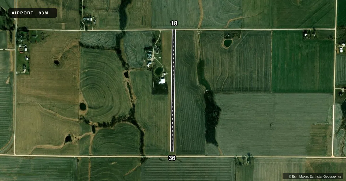
Runways & pattern
Full pagePattern entry · RWY 18
LEFT TRAFFICRunway end performance
| End | TORA | TODA | ASDA | LDA | VGSI | Approach lights | Obstruction |
|---|---|---|---|---|---|---|---|
| 18 | — | — | — | — | — | — | 14', fence, 67' from thr, 0' R of cntrln, slope 4 |
| 36 | — | — | — | — | — | — | 14', fence, 45' from thr, 0' R of cntrln, slope 3 |
Declared distances in feet. TORA = takeoff run available, TODA = takeoff distance, ASDA = accelerate-stop, LDA = landing distance.
Airport sketch
Runways drawn to scale from FAA survey coordinates, rendered over satellite imagery. Not for navigation.
Approaches & charts
Services on the field
Fuel grades, oxygen, maintenance, ramp storage and lighting — as declared to the FAA by the airport operator.
Fuel & services
- Fuel
- Not available
Ramp & ground
- Transient storage
- Not published
Fuel & FBOs
Cheapest 100LL and Jet A on the field and nearby. Always confirm with the FBO before taxi.
Airport notes
Surface conditions, obstructions, local procedures, lighting outages and other notes published with each FAA cycle.
VFR map & nearby airports
VFR sectional. Tap any ICAO chip to open that airport.
Key facts · 93M
Answer card- ICAO
- 93M
- Name
- RUETER AIRFIELD
- Location
- PALMYRA, MISSOURI
- Elevation
- 657 ft MSL
- Traffic pattern altitude
- 1,657 ft MSL (1,000 AGL)
- Control tower
- Non-towered (use CTAF)
- Total runways
- 1
- Longest runway
- 18/36 · 2,551 ft
- Published ILS approaches
- 0
- Published frequencies
- 1
- Magnetic variation
- –
- Current flight rules
- VFR
- Current wind
- 220° at 4 kt
- Favored runway now
- RWY 18
Rueter Airfield sits near Palmyra, Missouri. The field elevation is 657 ft MSL. It has one runway. The longest runway is 18/36 at 2,551 ft on turf. There is no control tower. CTAF is 122.9.
No ILS approaches are published here. Pattern altitude is not published, so use the standard 1,000 ft AGL pattern unless local guidance says otherwise. That puts the traffic pattern near 1,657 ft MSL based on the field elevation. Verify the current Chart Supplement before you fly. Magnetic variation is unknown in the provided data. Treat the listed runway headings as the published runway numbers. Confirm any heading details on the current chart.
There are no on-field FBOs listed. Plan fuel and services with the airport operator or the FBO directly by phone before arrival. With a turf runway and no tower, first-time arrivals should pay close attention to surface condition. Wind and aircraft performance matter here. This is a small uncontrolled field. Standard self-announce traffic discipline matters on CTAF.