METAR & TAF I63
Current METAR
Observed 13:35Z
KI63 271335Z AUTO 16008KT 10SM CLR 28/25 A2989 RMK AO2 T02790248
- Wind
- 160° @ 8 kt
- Visibility
- 10 SM
- Temp / Dew
- 28°C / 25°C
- Altimeter
- 29.89 inHg
- Clouds
- CLR
- Density alt
- 2,507 ft
- Ceiling
- Unlimited
- Rules
- VFR
Airport info & contacts
Manager on record, flight service, ARTCC, attendance schedule and pattern altitude — published by the FAA and refreshed every 28 days.
Location
- From city
- 2 NM W
- VFR sectional
- ST LOUIS
- ARTCC
- ZKC · KANSAS CITY
- NOTAM facility
- STL (NOTAM-D)
Airport manager
- Name
- PAUL WALKER
- Phone
- 217-779-7329
- Address
- 145 W. MAIN, MOUNT STERLING IL 62353
Flight service · Hours
- FSS STL
- SAINT LOUIS1-800-WX-BRIEF
- Attendance
- IREG
Frequencies
Tap any row to copy the frequency to your clipboard.
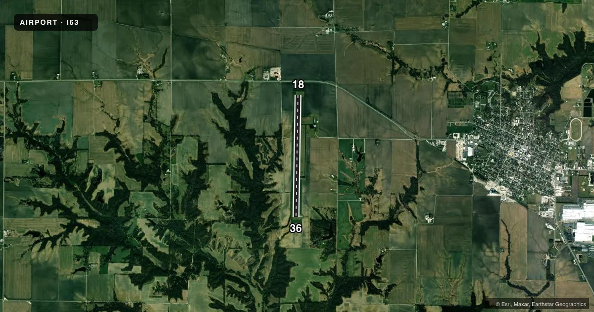
Runways & pattern
Full pagePattern entry · RWY 18
LEFT TRAFFICRunway end performance
| End | TORA | TODA | ASDA | LDA | VGSI | Approach lights | Obstruction |
|---|---|---|---|---|---|---|---|
| 18 | — | — | — | — | PAPI 4-box left(3°) | — | 44', pole, 1577' from thr, 255' R of cntrln, slope 31 |
| 36 | — | — | — | — | PAPI 4-box left(3°) | — | — |
Declared distances in feet. TORA = takeoff run available, TODA = takeoff distance, ASDA = accelerate-stop, LDA = landing distance.
Airport sketch
Runways drawn to scale from FAA survey coordinates, rendered over satellite imagery. Not for navigation.
Approaches & charts
Services on the field
Fuel grades, oxygen, maintenance, ramp storage and lighting — as declared to the FAA by the airport operator.
Fuel & services
- Fuel
- 100LLA
- Other services
- AGRI
Ramp & ground
- Transient storage
- Tie-down
- Lighting schedule
- SEE RMK
- Beacon schedule
- SS-SR
- Beacon
- White / Green (civil land)(WG)
- Wind indicator
- Lighted
- Segmented circle
- No
Fuel & FBOs
Cheapest 100LL and Jet A on the field and nearby. Always confirm with the FBO before taxi.
Airport notes
Surface conditions, obstructions, local procedures, lighting outages and other notes published with each FAA cycle.
General notes
- FOR CD CTC KANSAS CITY ARTCC AT 913-254-8508.
Lighting notes
- ACTVT MIRL RWY 18/36; PAPI RWY 18 & 36 - CTAF.
Fuel notes
- 100LLFUEL NOW AVBL TO PUBLIC - SELF SERVICE.
Other notes
- OWNEREXT 12644
VFR map & nearby airports
VFR sectional. Tap any ICAO chip to open that airport.
Key facts · I63
Answer card- ICAO
- I63
- Name
- MOUNT STERLING MUNI
- Location
- MOUNT STERLING, ILLINOIS
- Elevation
- 733.7 ft MSL
- Traffic pattern altitude
- 1,733.7 ft MSL (1,000 AGL)
- Control tower
- Non-towered (use CTAF)
- Total runways
- 1
- Longest runway
- 18/36 · 5,905 ft
- Published ILS approaches
- 0
- Published frequencies
- 2
- Magnetic variation
- 1°
- Current flight rules
- VFR
- Current wind
- 160° at 8 kt
- Favored runway now
- RWY 18
Mount Sterling Muni sits in Mount Sterling, Illinois. The field elevation is 733.7 ft MSL. It has one runway. Runway 18/36 is 5,905 ft of asphalt, so it gives light aircraft plenty of room and gives turboprops a workable strip when conditions are normal. The airport is not towered. CTAF and UNICOM are both 122.8.
No ILS approaches are published here. The pattern altitude is not published in the facts, so use the standard 1,000 ft AGL for light piston traffic unless the current Chart Supplement says otherwise. The runway lights are medium intensity on 18/36. The PAPI on both ends is controlled on CTAF, so monitor the field frequency if you need glidepath guidance.
Mount Sterling Municipal Airport is the on-field FBO. It carries 100LL and Jet A. Self-serve 100LL is available to the public. For clearance delivery, contact Kansas City Center at 913-254-8508. First-time arrivals should plan for non-towered operations and verify any current local procedures before taxi. The airport sits in central Illinois, so weather and visibility can change fast with seasonal fronts. Check the current Chart Supplement for anything affecting pattern work or local operating notes before you go.