METAR & TAF K06
K06 does not publish a METAR.
Showing the nearest reporting station: KIJX (JACKSONVILLE MUNI) · 14.2 NM away. Conditions at K06 may differ.
METAR · KIJX
Observed 13:15Z
KIJX 271315Z AUTO 19014G18KT 10SM SCT008 27/27 A2991 RMK AO2 T02740270
- Wind
- 190° @ 14G18 kt
- Visibility
- 10 SM
- Temp / Dew
- 27°C / 27°C
- Altimeter
- 29.91 inHg
- Clouds
- SCT
- Density alt
- 2,029 ft
- Ceiling
- Unlimited
- Rules
- VFR
Airport info & contacts
Manager on record, flight service, ARTCC, attendance schedule and pattern altitude — published by the FAA and refreshed every 28 days.
Location
- From city
- 3 NM SE
- VFR sectional
- ST LOUIS
- ARTCC
- ZKC · KANSAS CITY
- NOTAM facility
- STL (NOTAM-D)
Airport manager
- Name
- MIKE GANN
- Phone
- (217) 323-3261
- Address
- CITY HALL 105 W. 3RD ST, BEARDSTOWN IL 62618-1142
Flight service · Hours
- FSS STL
- SAINT LOUIS1-800-WX-BRIEF
- Attendance
- Unattended
Frequencies
Tap any row to copy the frequency to your clipboard.
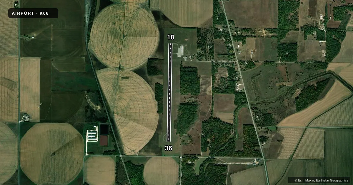
Runways & pattern
Full pagePattern entry · RWY 18
LEFT TRAFFICRunway end performance
| End | TORA | TODA | ASDA | LDA | VGSI | Approach lights | Obstruction |
|---|---|---|---|---|---|---|---|
| 18 | — | — | — | — | — | — | 22', trees, 640' from thr, 0' R of cntrln, slope 20 |
Declared distances in feet. TORA = takeoff run available, TODA = takeoff distance, ASDA = accelerate-stop, LDA = landing distance.
Airport sketch
Runways drawn to scale from FAA survey coordinates, rendered over satellite imagery. Not for navigation.
Approaches & charts
Services on the field
Fuel grades, oxygen, maintenance, ramp storage and lighting — as declared to the FAA by the airport operator.
Fuel & services
- Fuel
- Not available
Ramp & ground
- Transient storage
- Tie-down
- Landing fee
- No fee published
- Customs
- Not available
- Lighting schedule
- SEE RMK
- Beacon schedule
- SS-SR
- Beacon
- White / Green (civil land)(WG)
- Wind indicator
- Lighted
- Segmented circle
- No
Fuel & FBOs
Cheapest 100LL and Jet A on the field and nearby. Always confirm with the FBO before taxi.
Airport notes
Surface conditions, obstructions, local procedures, lighting outages and other notes published with each FAA cycle.
General notes
- (E81) TWY LGTS AT ENTRANCE ONLY.
- FOR CD CTC ST LOUIS APCH 314-890-1017.
Lighting notes
- LIRL RY 18/36 PRESET ON LOW INTST; TO INCR INTST ACTVT - CTAF.
VFR map & nearby airports
VFR sectional. Tap any ICAO chip to open that airport.
Key facts · K06
Answer card- ICAO
- K06
- Name
- GREATER BEARDSTOWN
- Location
- BEARDSTOWN, ILLINOIS
- Elevation
- 465 ft MSL
- Traffic pattern altitude
- 1,465 ft MSL (1,000 AGL)
- Control tower
- Non-towered (use CTAF)
- Total runways
- 1
- Longest runway
- 18/36 · 4,000 ft
- Published ILS approaches
- 0
- Published frequencies
- 1
- Magnetic variation
- 2°
- Current flight rules
- VFR
- Current wind
- 190° at 14 kt
- Favored runway now
- RWY 18
Greater Beardstown (K06) sits in Beardstown, Illinois. The field elevation is 465 ft MSL. It has one runway, 18/36, which is 4,000 ft of asphalt. There is no control tower. CTAF is 122.9. No ILS approaches are published here.
Pattern altitude is not published. For light piston traffic, use 1,000 ft AGL unless the current Chart Supplement says otherwise. That puts the pattern at 1,465 ft MSL based on the field elevation. Verify before you go if your aircraft or local procedure calls for something different.
There are no on-field FBOs listed in the facts, so plan ahead for fuel and ground support. Check with the airport operator directly before arrival, or call the field on CTAF for current FBO availability. Published remarks say the runway lights on 18/36 are preset to low intensity. You can increase them by keying the CTAF. Taxiway lights are only at the entrance. For clearance delivery, contact St Louis Approach at 314-890-1017. This is a non-towered field, so expect self-announced traffic and keep a close ear on CTAF.