METAR & TAF KSPI
Current METAR
Observed 05:52Z
KSPI 270552Z AUTO 11003KT 10SM CLR 27/26 A2985 RMK AO2 SLP102 T02720256 10328 20272 403390222 58009 $
- Wind
- 110° @ 3 kt
- Visibility
- 10 SM
- Temp / Dew
- 27°C / 26°C
- Altimeter
- 29.85 inHg
- Clouds
- CLR
- Density alt
- 2,268 ft
- Ceiling
- Unlimited
- Rules
- VFR
Airport info & contacts
Manager on record, flight service, ARTCC, attendance schedule and pattern altitude — published by the FAA and refreshed every 28 days.
Location
- From city
- 3 NM NW
- VFR sectional
- ST LOUIS
- ARTCC
- ZKC · KANSAS CITY
- NOTAM facility
- SPI (NOTAM-D)
Airport manager
- Name
- MARK HANNA
- Phone
- 217-788-1080
- Address
- CAPITAL AIRPORT, SPRINGFIELD IL 62707-8419
Flight service · Hours
- FSS STL
- SAINT LOUIS1-800-WX-BRIEF
- Attendance
- 0530-0000
Frequencies
Tap any row to copy the frequency to your clipboard.
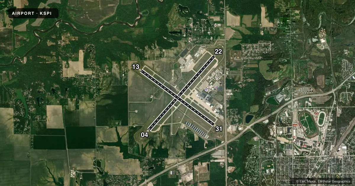
Runways & pattern
Full pagePattern entry · RWY 13
LEFT TRAFFIC| Runway | Heading (°M) | Length | Surface | Traffic |
|---|---|---|---|---|
| 04/22 | 41° / 221° | 8,001 ft | CONC | Standard L |
| 13/31Favored | 126° / 306° | 7,399 ft | ASPH | Standard L |
Runway end performance
| End | TORA | TODA | ASDA | LDA | VGSI | Approach lights | Obstruction |
|---|---|---|---|---|---|---|---|
| 04 | 8,001' | 8,001' | 7,927' | 7,927' | VASI 4-box left(3°) | MALSR | 49', tree, 2239' from thr, 758' R of cntrln, slope 41 |
| 22 | 8,001' | 8,001' | 8,001' | 8,001' | VASI 4-box left(3°) | MALSR | 78', tree, 4040' from thr, 704' R of cntrln, slope 49 |
| 13 | 7,399' | 7,399' | 7,216' | 7,216' | PAPI 4-box right(3°) | — | 74', trees, 3131' from thr, 383' R of cntrln, slope 39 |
| 31 | 7,399' | 7,399' | 7,000' | 7,000' | VASI 4-box left(3°) | MALSR | 22', tree, 1142' from thr, 628' R of cntrln, slope 42 |
Declared distances in feet. TORA = takeoff run available, TODA = takeoff distance, ASDA = accelerate-stop, LDA = landing distance.
Airport sketch
Runways drawn to scale from FAA survey coordinates, rendered over satellite imagery. Not for navigation.
Approaches & charts
ILS · 3
Services on the field
Fuel grades, oxygen, maintenance, ramp storage and lighting — as declared to the FAA by the airport operator.
Fuel & services
- Fuel
- 100LLAJ8
- Oxygen (bottled)
- Not available
- Oxygen (bulk)
- HIGH/LOW
- Airframe repair
- Major
- Power plant repair
- Major
- Other services
- CHTR,INSTR,RNTL
Ramp & ground
- Transient storage
- Tie-down
- Hangar
- Landing fee
- No fee published
- Customs
- Not available
- Lighting schedule
- SEE RMK
- Beacon schedule
- SS-SR
- Beacon
- White / Green (civil land)(WG)
- Wind indicator
- Lighted
- Segmented circle
- No
Fuel & FBOs
Cheapest 100LL and Jet A on the field and nearby. Always confirm with the FBO before taxi.
Airport notes
Surface conditions, obstructions, local procedures, lighting outages and other notes published with each FAA cycle.
General notes
- TWY Y1, TWY Y2, AND TWY Y BTN TWY Y1 AND TWY A NOT AVBL FOR AIR CARRIER OPS WITH MORE THAN 9 PAX SEATS.
- GENERAL AVIATION ACCESS TO & PARKING ON THE ACR RAMP IS PROHIBITED.
- WX SVC AVBL H24.
- DURING SNOW REMOVAL OPS EQUIPMENT OPERATORS WILL MONITOR CTAF WHEN THE TWR IS CLSD.
- DASSP GATEWAY ARPT CALL 217-788-1080.
- FOR CD IF UNA TO CTC ON FSS FREQ, CTC ST LOUIS APCH AT 314-890-1017.
- 100LL SELF SERVE AVBL 24HRS.
Lighting notes
- WHEN ATCT CLSD ACTVT HIRL RY 13/31; HIRL RY 04/22; MALSR RYS 04; 22 & 31; VASI RY 31; REIL RY 13 - CTAF. PAPI RY 13 & VASI RYS 04 & 22 OPER CONTINUOUSLY.
Runway surface & condition
- 04/22PCR VALUE: 830/R/C/W/T
- 13/31PCR VALUE: 830/F/C/X/T
Approach & departure obstructions
- 22150 FT WIDTH.
Other notes
- ARFF UNAVBL FOR UNSKED ACFT OPS 0600-1130Z++ DLY EXC WITH PPR, CALL 217-788-1080.
VFR map & nearby airports
VFR sectional. Tap any ICAO chip to open that airport.
Key facts · KSPI
Answer card- ICAO
- KSPI
- Name
- ABRAHAM LINCOLN CAPITAL
- Location
- SPRINGFIELD, ILLINOIS
- Elevation
- 597.9 ft MSL
- Traffic pattern altitude
- 1,597.9 ft MSL (1,000 AGL)
- Control tower
- Towered · 0600-2200
- Total runways
- 2
- Longest runway
- 04/22 · 8,001 ft
- Published ILS approaches
- 3
- Published frequencies
- 16
- Magnetic variation
- 1°
- Current flight rules
- VFR
- Current wind
- 110° at 3 kt
- Favored runway now
- RWY 13
Abraham Lincoln Capital Airport sits in Springfield, Illinois. The field elevation is 597.9 ft MSL. It has 2 runways. The longest is 8,001 ft on runway 04/22. Runway 13/31 is 7,399 ft. The tower is open daily from 0600 to 2200. When the tower is closed, use CTAF 121.3 and follow the published lighting procedures for the runway you plan to use. Three ILS approaches are published for runway ends 04, 22 and 31.
Pattern altitude is not published. Use 1,000 ft AGL for light piston traffic unless ATC or the current Chart Supplement says otherwise. The airport has one on-field FBO, Stellar Aviation of Springfield. It carries 100LL, Jet A and Jet A Prist. Self-serve 100LL is available 24 hours. General aviation access to the aircraft ramp is prohibited. Parking on the ramp is also prohibited, so plan your ground handling before arrival.
First-time pilots should pay attention to the tower hours. The ramp restriction matters here. The lighting setup after hours is also worth a close look. There is a published note that taxiways Y1, Y2 and the segment of Y between Y1 and A are not available for air carrier operations with more than 9 passenger seats. If you are operating unscheduled and need ARFF coverage, call ahead. Weather service is available 24 hours a day. For clearance delivery help if FSS is not reachable, contact St Louis Approach.