METAR & TAF KTAZ
Current METAR
Observed 20:28Z
KTAZ 092028Z AUTO 22007KT 10SM VCTS SCT033 SCT050 BKN070 29/24 A2989 RMK AO2 LTG DSNT SE THRU W
- Wind
- 220° @ 7 kt
- Visibility
- 10 SM
- Temp / Dew
- 29°C / 24°C
- Altimeter
- 29.89 inHg
- Clouds
- BKN
- Density alt
- 2,488 ft
- Ceiling
- 7,000 ft AGL
- Rules
- VFR
Airport info & contacts
Manager on record, flight service, ARTCC, attendance schedule and pattern altitude — published by the FAA and refreshed every 28 days.
Location
- From city
- 2 NM SW
- VFR sectional
- ST LOUIS
- ARTCC
- ZKC · KANSAS CITY
- NOTAM facility
- TAZ (NOTAM-D)
Airport manager
- Name
- ANDY GOODALL
- Phone
- 217-824-9313
- Address
- 1501 S. SPRESSER, TAYLORVILLE IL 62568
Flight service · Hours
- FSS STL
- SAINT LOUIS1-800-WX-BRIEF
- Attendance
- MON-FRI · 0900-1700
Frequencies
Tap any row to copy the frequency to your clipboard.
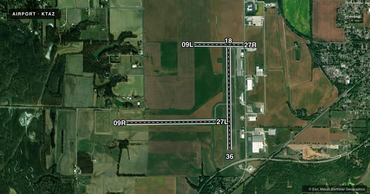
Runways & pattern
Full pagePattern entry · RWY 18
LEFT TRAFFIC| Runway | Heading (°M) | Length | Surface | Traffic |
|---|---|---|---|---|
| 18/36Favored | 179° / 359° | 4,001 ft | ASPH | Standard L |
| 09R/27L | 90° / 270° | 3,501 ft | ASPH | 09R R |
| 09L/27R | 90° / 270° | 1,933 ft | TURF | 27R R |
Runway end performance
| End | TORA | TODA | ASDA | LDA | VGSI | Approach lights | Obstruction |
|---|---|---|---|---|---|---|---|
| 18 | — | — | — | — | PSIL(3°) | — | — |
| 36 | — | — | — | — | PSIL(3°) | — | — |
| 09R | — | — | — | — | PSIL(3°) | — | — |
| 27L | — | — | — | — | PSIL(4°) | — | — |
| 27R | — | — | — | — | — | — | 14', road, 22' from thr, 0' R of cntrln, slope 1 |
Declared distances in feet. TORA = takeoff run available, TODA = takeoff distance, ASDA = accelerate-stop, LDA = landing distance.
Airport sketch
Runways drawn to scale from FAA survey coordinates, rendered over satellite imagery. Not for navigation.
Approaches & charts
Services on the field
Fuel grades, oxygen, maintenance, ramp storage and lighting — as declared to the FAA by the airport operator.
Fuel & services
- Fuel
- 100LLA
- Airframe repair
- Major
- Power plant repair
- Major
- Other services
- INSTR,PAJA,RNTL
Ramp & ground
- Transient storage
- Tie-down
- Hangar
- Landing fee
- No fee published
- Customs
- Not available
- Lighting schedule
- SEE RMK
- Beacon schedule
- SS-SR
- Beacon
- White / Green (civil land)(WG)
- Wind indicator
- Lighted
- Segmented circle
- Yes
Fuel & FBOs
Cheapest 100LL and Jet A on the field and nearby. Always confirm with the FBO before taxi.
Airport notes
Surface conditions, obstructions, local procedures, lighting outages and other notes published with each FAA cycle.
General notes
- 172 FT LGTD WATER TWR LCT 3007 FT FM RWY 27L END 488 FT L.
- FOR CD CTC ST LOUIS APCH 314-890-1017.
Lighting notes
- ACVT REIL RWY 09R, 18 & 27L; PVASI RWY 09R, 18, 27L & 36; MIRL RWY 09R/27L - CTAF. MIRL RWY 18/36 PRE-SET LOW INTST TO INCR INTST - CTAF.
Fuel notes
- 100LLSELF SVC FUEL LCTD ON N RAMP AVBL H24 WITH CREDIT CARD.
Approach & departure obstructions
- 09LMKD WITH WHITE ROCKS.
- 09RUNUSBL BYD 8 DEG RIGHT OF CNTRLN.
- 18UNUSBL BYD 6 DEG LEFT & RIGHT OF CNTRLN. OPR ONLY WHEN RWY LGT ARE ACT BY CTAF.
- 27LUNUSBL 6 DEG RIGHT & 8 DEG LEFT OF CNTRLN.
- 36UNUSBL BYD 5 DEG LEFT & RIGHT OF CNTRLN.
- 27RAPCH RATIO TO DSPLCD THLD 21:1 WHEN CONSIDERING 28 FT BLDG 592 FT 96 FT L OF CNTRLN.
Other notes
- TPA: RWY 09L/27R 600 FT AGL; RWY 09R/27L & RWY 18/36 800 FT AGL.
VFR map & nearby airports
VFR sectional. Tap any ICAO chip to open that airport.
Key facts · KTAZ
Answer card- ICAO
- KTAZ
- Name
- TAYLORVILLE MUNI
- Location
- TAYLORVILLE, ILLINOIS
- Elevation
- 622 ft MSL
- Traffic pattern altitude
- 1,622 ft MSL (1,000 AGL)
- Control tower
- Non-towered (use CTAF)
- Total runways
- 3
- Longest runway
- 18/36 · 4,001 ft
- Published ILS approaches
- 0
- Published frequencies
- 4
- Magnetic variation
- 0°
- Current flight rules
- VFR
- Current wind
- 220° at 7 kt
- Favored runway now
- RWY 18
Taylorville Muni sits in Taylorville, Illinois. Field elevation is 622 ft MSL. The airport has three runways. The longest is runway 18/36 at 4,001 ft. There is no control tower. CTAF and UNICOM are both 122.8. St Louis Approach handles clearance delivery. No ILS approaches are published here.
Pattern altitude is not published as a single field value. Use 600 ft AGL for runway 09L/27R. Use 800 ft AGL for runways 09R/27L and 18/36. That matters here because the field has mixed pavement and turf. It also has a few runway-specific notes that can catch a first-time visitor.
Taylorville Municipal Airport is on the field. It carries 100LL and Jet A with Prist. Self-serve 100LL is on the north ramp. It is available 24 hours with a credit card. Runway 09L is marked with white rocks. Runway 27R has a displaced threshold note tied to a building near the approach path. Runway 36 has a visual glide slope indicator limitation near the centerline. Runway 18 lighting is only permitted when runway lights are activated by CTAF. The airport also has medium intensity runway lights on 09R/27L and 18/36. If you are planning a night arrival or a first visit, review the current Chart Supplement and brief the runway-specific lighting and obstacle notes before you go.