METAR & TAF KGRE
KGRE does not publish a METAR.
Showing the nearest reporting station: KSLO (SALEM-LECKRONE) · 22.6 NM away. Conditions at KGRE may differ.
METAR · KSLO
Observed 12:35Z
KSLO 271235Z 10SM CLR 24/21 A2994 RMK AO2 T02380214
- Wind
- Calm
- Visibility
- 10 SM
- Temp / Dew
- 24°C / 21°C
- Altimeter
- 29.94 inHg
- Clouds
- CLR
- Density alt
- 1,726 ft
- Ceiling
- Unlimited
- Rules
- VFR
Airport info & contacts
Manager on record, flight service, ARTCC, attendance schedule and pattern altitude — published by the FAA and refreshed every 28 days.
Location
- From city
- 3 NM S
- VFR sectional
- ST LOUIS
- Pattern altitude
- 800 ft AGL · 1,341 ft MSL
- ARTCC
- ZKC · KANSAS CITY
- NOTAM facility
- STL (NOTAM-D)
Airport manager
- Name
- LARRY KLEINER
- Phone
- 618-664-0926
- Address
- 1374 SKY LANE, GREENVILLE IL 62246
Flight service · Hours
- FSS STL
- SAINT LOUIS1-800-WX-BRIEF
- Attendance
- 0730-1700
Frequencies
Tap any row to copy the frequency to your clipboard.
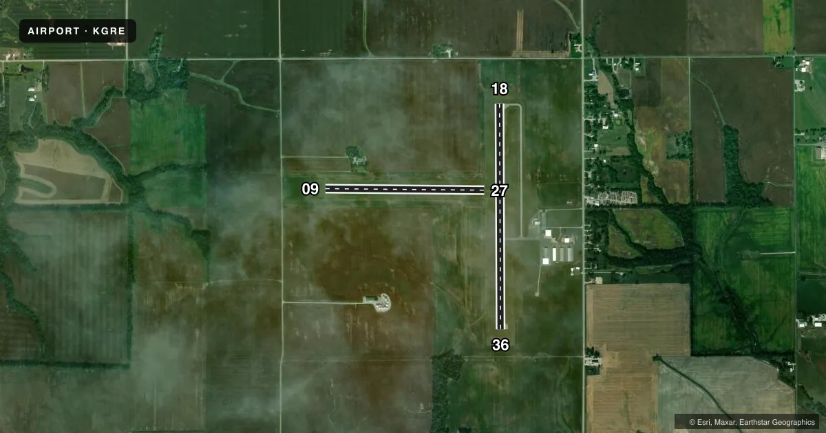
Runways & pattern
Full pagePattern entry · RWY 18
LEFT TRAFFIC| Runway | Heading (°M) | Length | Surface | Traffic |
|---|---|---|---|---|
| 18/36 | 177° / 357° | 4,002 ft | ASPH | Standard L |
| 09/27 | 88° / 268° | 2,822 ft | TURF | Standard L |
Runway end performance
| End | TORA | TODA | ASDA | LDA | VGSI | Approach lights | Obstruction |
|---|---|---|---|---|---|---|---|
| 18 | — | — | — | — | PSIL(3°) | — | — |
Declared distances in feet. TORA = takeoff run available, TODA = takeoff distance, ASDA = accelerate-stop, LDA = landing distance.
Airport sketch
Runways drawn to scale from FAA survey coordinates, rendered over satellite imagery. Not for navigation.
Approaches & charts
Services on the field
Fuel grades, oxygen, maintenance, ramp storage and lighting — as declared to the FAA by the airport operator.
Fuel & services
- Fuel
- 100LLA
- Oxygen (bottled)
- Not available
- Oxygen (bulk)
- Not available
- Airframe repair
- Not available
- Power plant repair
- Not available
- Other services
- GLD,INSTR,PAJA,RNTL,SALES,TOW
Ramp & ground
- Transient storage
- Tie-down
- Hangar
- Landing fee
- No fee published
- Customs
- Not available
- Lighting schedule
- SEE RMK
- Beacon schedule
- SS-SR
- Beacon
- White / Green (civil land)(WG)
- Wind indicator
- Lighted
- Segmented circle
- No
Fuel & FBOs
Cheapest 100LL and Jet A on the field and nearby. Always confirm with the FBO before taxi.
Airport notes
Surface conditions, obstructions, local procedures, lighting outages and other notes published with each FAA cycle.
General notes
- INTENSIVE PARACHUTE OPS.
- AWOS 3 CLICKS ON CTAF.
- DOOR CODE FOR BUILDING ENTRY IS CTAF, THEN #
- FOR CD CTC KANSAS CITY ARTCC AT 913-254-8508.
Lighting notes
- MIRL RY 18/36 PRESET ON MED INTST; TO INCR INTST ACTVT - CTAF.
Other notes
- MANAGEROR 618-664-3272
VFR map & nearby airports
VFR sectional. Tap any ICAO chip to open that airport.
Key facts · KGRE
Answer card- ICAO
- KGRE
- Name
- GREENVILLE
- Location
- GREENVILLE, ILLINOIS
- Elevation
- 540.8 ft MSL
- Traffic pattern altitude
- 1,340.8 ft MSL (800 AGL)
- Control tower
- Non-towered (use CTAF)
- Total runways
- 2
- Longest runway
- 18/36 · 4,002 ft
- Published ILS approaches
- 0
- Published frequencies
- 2
- Magnetic variation
- 2°
- Current flight rules
- VFR
- Current wind
- Calm / unavailable
- Favored runway now
- –
Greenville Airport sits in Greenville, Illinois. Field elevation is 540.8 ft MSL. The airport has two runways. The longest is 4,002 ft asphalt runway 18/36. Runway 09/27 is 2,822 ft turf. There is no control tower. CTAF and UNICOM are both 123.05.
Pattern altitude is 800 ft AGL, which is 1,340.8 ft MSL. No ILS approaches are published here, so plan with the current charted procedures before you go. Greenville Airport is a good one to brief carefully because intensive parachute operations occur. Expect to stay alert in the pattern and on CTAF. Medium intensity runway lights on 18/36 are preset. Use CTAF to increase intensity if needed.
Greenville Airport is on the field and carries AVGAS 100LL and Jet A Prist. The airport remarks also note that AWOS is available by clicking three times on CTAF. For clearance delivery, contact Kansas City Air Route Traffic Control Center. The manager phone number is published in the Chart Supplement. If you need any operational detail that is not in the airport remarks, verify it with the airport operator before departure.