METAR & TAF KSLO
Current METAR
Observed 10:35Z
KSLO 271035Z 10SM CLR 24/21 A2994 RMK AO2 LTG DSNT E AND SE T02350208
- Wind
- Calm
- Visibility
- 10 SM
- Temp / Dew
- 24°C / 21°C
- Altimeter
- 29.94 inHg
- Clouds
- CLR
- Density alt
- 1,766 ft
- Ceiling
- Unlimited
- Rules
- VFR
Airport info & contacts
Manager on record, flight service, ARTCC, attendance schedule and pattern altitude — published by the FAA and refreshed every 28 days.
Location
- From city
- 2 NM NW
- VFR sectional
- ST LOUIS
- ARTCC
- ZKC · KANSAS CITY
- NOTAM facility
- SLO (NOTAM-D)
Airport manager
- Name
- ROBERT L.TATE JR
- Phone
- 618-367-0114
- Address
- 1100 AIRPORT RD, SALEM IL 62881
Flight service · Hours
- FSS STL
- SAINT LOUIS1-800-WX-BRIEF
- Attendance
- ALL
Frequencies
Tap any row to copy the frequency to your clipboard.
Runways & pattern
Full pagePattern entry · RWY 18
LEFT TRAFFICRunway end performance
| End | TORA | TODA | ASDA | LDA | VGSI | Approach lights | Obstruction |
|---|---|---|---|---|---|---|---|
| 18 | — | — | — | — | PAPI 4-box left(3°) | — | — |
| 36 | — | — | — | — | PAPI 4-box right(3°) | — | — |
Declared distances in feet. TORA = takeoff run available, TODA = takeoff distance, ASDA = accelerate-stop, LDA = landing distance.
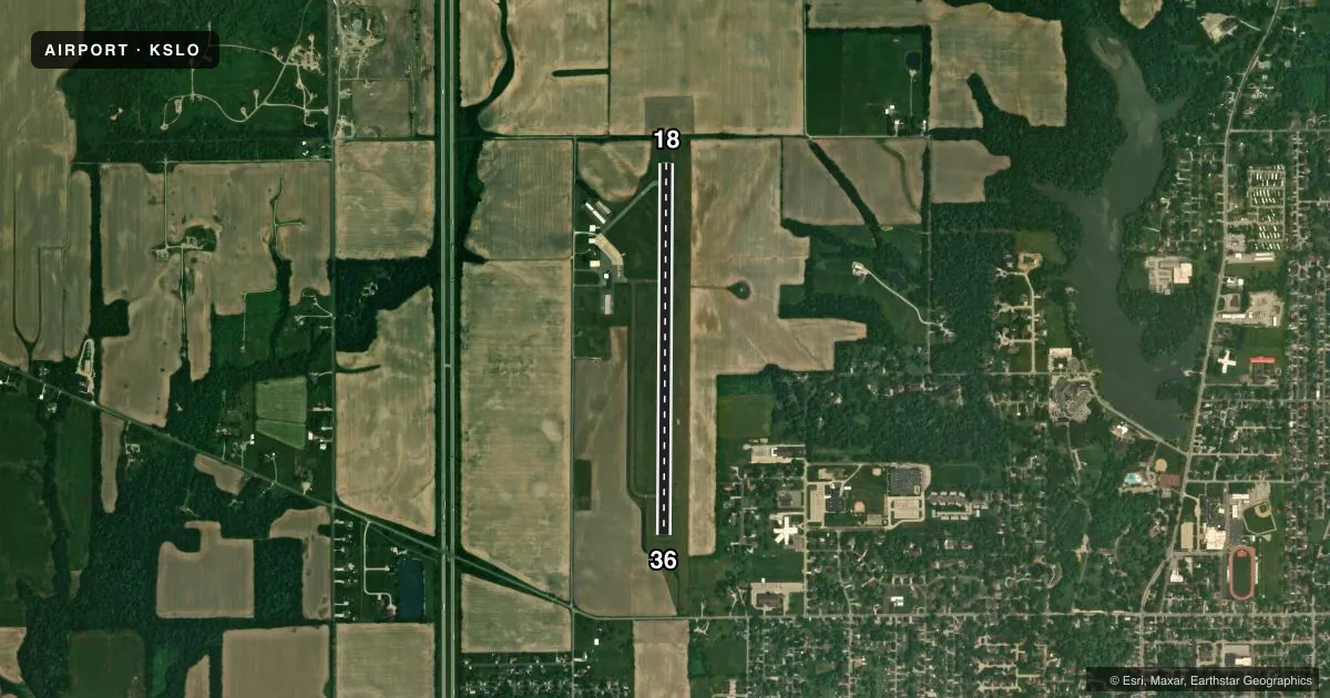
Airport sketch
Runways drawn to scale from FAA survey coordinates, rendered over satellite imagery. Not for navigation.
Approaches & charts
Services on the field
Fuel grades, oxygen, maintenance, ramp storage and lighting — as declared to the FAA by the airport operator.
Fuel & services
- Fuel
- 100LL
- Oxygen (bottled)
- Not available
- Oxygen (bulk)
- Not available
- Airframe repair
- Not available
- Power plant repair
- Not available
- Other services
- INSTR,RNTL,SALES
Ramp & ground
- Transient storage
- Tie-down
- Hangar
- Landing fee
- No fee published
- Customs
- Not available
- Lighting schedule
- SEE RMK
- Beacon schedule
- SS-SR
- Beacon
- White / Green (civil land)(WG)
- Wind indicator
- Lighted
- Segmented circle
- No
Fuel & FBOs
Cheapest 100LL and Jet A on the field and nearby. Always confirm with the FBO before taxi.
Airport notes
Surface conditions, obstructions, local procedures, lighting outages and other notes published with each FAA cycle.
General notes
- FOR CD CTC KANSAS CITY ARTCC AT 913-254-8508.
Lighting notes
- MIRL RY 18/36 PRESET LOW INTST; TO INCR INTST & ACTVT PAPI RY 18/36, REIL RY 18/36 - CTAF.
Fuel notes
- 100LL100LL IS SELF-SERVE W/CREDIT CARD.
Approach & departure obstructions
- 36RY 36 PAPI UNUSBL BYD 8 DEG LEFT AND RIGHT OF CNTRLN.
VFR map & nearby airports
VFR sectional. Tap any ICAO chip to open that airport.
Key facts · KSLO
Answer card- ICAO
- KSLO
- Name
- SALEM-LECKRONE
- Location
- SALEM, ILLINOIS
- Elevation
- 573.2 ft MSL
- Traffic pattern altitude
- 1,573.2 ft MSL (1,000 AGL)
- Control tower
- Non-towered (use CTAF)
- Total runways
- 1
- Longest runway
- 18/36 · 4,098 ft
- Published ILS approaches
- 0
- Published frequencies
- 2
- Magnetic variation
- 1°
- Current flight rules
- VFR
- Current wind
- Calm / unavailable
- Favored runway now
- –
Salem-Leckrone Airport sits in Salem, Illinois. The field elevation is 573.2 ft MSL. It has one runway, 18/36, which is 4,098 ft long and paved with asphalt. There is no control tower. CTAF and UNICOM are both 122.725. No ILS approaches are published here.
Pattern altitude is not published. Use the standard 1,000 ft AGL pattern unless the current Chart Supplement says otherwise. For this field that works out to about 1,573 ft MSL. Magnetic variation is 1°, so keep that in mind when you are briefing runway alignment.
Tate's Flying Service is on the field. It carries AVGAS 100LL. Self-serve 100LL is available with credit card. The published remarks also note that runway 18/36 lighting is preset to low intensity. Use CTAF to increase the lights and to activate the PAPI and runway end identifier lights. The PAPI on runway 36 is unusable more than 8 degrees left or right of centerline.
For a first-time arrival, the big things are simple. This is an uncontrolled field with one runway, so listen closely on CTAF and watch for local traffic. If you need clearance delivery, contact Kansas City ARTCC at 913-254-8508. Check the current Chart Supplement for any updated lighting notes or other operational changes before you go.