METAR & TAF KFOA
Current METAR
Observed 22:15Z
KFOA 262215Z AUTO 28006KT 10SM CLR 32/27 A2987 RMK AO2
- Wind
- 280° @ 6 kt
- Visibility
- 10 SM
- Temp / Dew
- 32°C / 27°C
- Altimeter
- 29.87 inHg
- Clouds
- CLR
- Density alt
- 2,688 ft
- Ceiling
- Unlimited
- Rules
- VFR
Airport info & contacts
Manager on record, flight service, ARTCC, attendance schedule and pattern altitude — published by the FAA and refreshed every 28 days.
Location
- From city
- 2 NM E
- VFR sectional
- ST LOUIS
- ARTCC
- ZKC · KANSAS CITY
- NOTAM facility
- FOA (NOTAM-D)
Airport manager
- Name
- KAREN PICKEL
- Phone
- 618-662-2823
- Address
- ONE AIRPORT ROAD, FLORA IL 62839
Flight service · Hours
- FSS STL
- SAINT LOUIS1-800-WX-BRIEF
- Attendance
- MON-FRI · 0800-1630
Frequencies
Tap any row to copy the frequency to your clipboard.
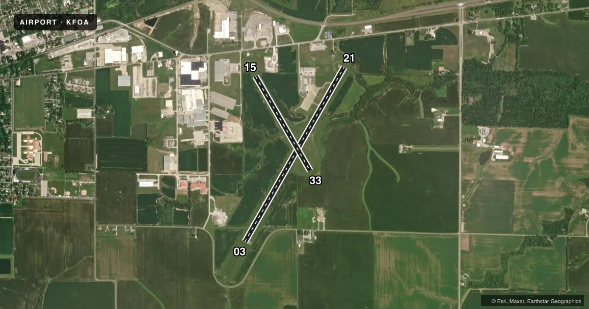
Runways & pattern
Full pagePattern entry · RWY 33
LEFT TRAFFIC| Runway | Heading (°M) | Length | Surface | Traffic |
|---|---|---|---|---|
| 03/21 | 29° / 209° | 5,003 ft | ASPH | Standard L |
| 15/33Favored | 149° / 329° | 2,715 ft | TURF | Standard L |
Runway end performance
| End | TORA | TODA | ASDA | LDA | VGSI | Approach lights | Obstruction |
|---|---|---|---|---|---|---|---|
| 03 | — | — | — | — | PSIL(3°) | — | 73', tree, 2708' from thr, 94' R of cntrln, slope 34 |
| 21 | — | — | — | — | PSIL(3°) | — | 46', tree, 1780' from thr, 62' R of cntrln, slope 34 |
| 15 | — | — | — | — | — | — | 46', tree, 611' from thr, 0' R of cntrln, slope 13 |
| 33 | — | — | — | — | — | — | 27', pline, 357' from thr, 160' R of cntrln, slope 13 |
Declared distances in feet. TORA = takeoff run available, TODA = takeoff distance, ASDA = accelerate-stop, LDA = landing distance.
Airport sketch
Runways drawn to scale from FAA survey coordinates, rendered over satellite imagery. Not for navigation.
Approaches & charts
ILS · 1
Services on the field
Fuel grades, oxygen, maintenance, ramp storage and lighting — as declared to the FAA by the airport operator.
Fuel & services
- Fuel
- 100LLA
- Oxygen (bottled)
- Not available
- Oxygen (bulk)
- Not available
- Airframe repair
- Not available
- Power plant repair
- Not available
- Other services
- RNTL
Ramp & ground
- Transient storage
- Tie-down
- Hangar
- Landing fee
- No fee published
- Customs
- Not available
- Lighting schedule
- SEE RMK
- Beacon schedule
- SS-SR
- Beacon
- White / Green (civil land)(WG)
- Wind indicator
- Lighted
- Segmented circle
- No
Fuel & FBOs
Cheapest 100LL and Jet A on the field and nearby. Always confirm with the FBO before taxi.
Airport notes
Surface conditions, obstructions, local procedures, lighting outages and other notes published with each FAA cycle.
General notes
- RY 15/33 SOFT WHEN WET.
- FOR CD CTC KANSAS CITY ARTCC AT 913-254-8508.
Lighting notes
- MIRL RY 03/21 PRESET ON LOW INTST; TO INCR INTST & ACTVT REIL RY 21; PLASI RYS 03/21 & TWY LGTS - CTAF.
Fuel notes
- 100LLFUEL SELF SVC WITH CREDIT CARD.
Approach & departure obstructions
- 15RWY 15 /33 THLDS & BOUNDARY OUTLINED BY WHITE 1/2 TIRES. DAY USE ONLY.
- 15APCH SLOPE 17:1 TO DSPLCD THR.
VFR map & nearby airports
VFR sectional. Tap any ICAO chip to open that airport.
Key facts · KFOA
Answer card- ICAO
- KFOA
- Name
- FLORA MUNI
- Location
- FLORA, ILLINOIS
- Elevation
- 472.6 ft MSL
- Traffic pattern altitude
- 1,472.6 ft MSL (1,000 AGL)
- Control tower
- Non-towered (use CTAF)
- Total runways
- 2
- Longest runway
- 03/21 · 5,003 ft
- Published ILS approaches
- 1
- Published frequencies
- 2
- Magnetic variation
- 1°
- Current flight rules
- VFR
- Current wind
- 280° at 6 kt
- Favored runway now
- RWY 33
Flora Muni sits in Flora, Illinois. The field elevation is 472.6 ft MSL. It has two runways. The longest is 5,003 ft on runway 03/21. There is no control tower, so plan for CTAF and UNICOM self-announce traffic. Pattern altitude is not published. Use the standard 1,000 ft AGL unless the current Chart Supplement says otherwise.
Runway 03/21 is asphalt. Runway 15/33 is turf and 2,715 ft long. The published remarks matter here. Runway 15/33 is soft when wet. It is day use only. The approach slope to the displaced threshold on 15 is 17 to 1. That is worth checking before you plan a short-field arrival. Runway 03/21 has medium intensity lights that come up on low by default. Use CTAF to raise intensity. CTAF also controls the PAPI on 03/21. Runway end identifier lights on 21 are also activated on CTAF.
There is one ILS approach to runway 21. For clearance delivery, contact Kansas City Center at the published number before departure if you need an IFR release or clearance. Flora Municipal Airport is on the field and carries 100LL and Jet A Prist. Fuel is self-serve with credit card. If you are new to the airport, watch the lighting setup and the turf runway condition after rain. Check the current FAA Chart Supplement for any changes before you go.