METAR & TAF KCUL
KCUL does not publish a METAR.
Showing the nearest reporting station: KFWC (FAIRFIELD MUNI) · 22.1 NM away. Conditions at KCUL may differ.
METAR · KFWC
Observed 06:15Z
KFWC 270615Z AUTO 14009KT 10SM VCTS SCT048 SCT055 23/21 A2989 RMK AO2 LTG DSNT N THRU SE T02310211
- Wind
- 140° @ 9 kt
- Visibility
- 10 SM
- Temp / Dew
- 23°C / 21°C
- Altimeter
- 29.89 inHg
- Clouds
- SCT
- Density alt
- 1,478 ft
- Ceiling
- Unlimited
- Rules
- VFR
Airport info & contacts
Manager on record, flight service, ARTCC, attendance schedule and pattern altitude — published by the FAA and refreshed every 28 days.
Location
- From city
- 2 NM E
- VFR sectional
- ST LOUIS
- ARTCC
- ZID · INDIANAPOLIS
- NOTAM facility
- CUL (NOTAM-D)
Airport manager
- Name
- RON IMMEL
- Phone
- 618-384-1631
- Address
- MUNICIPAL BUILDING 225 EAST MAIN, CARMI IL 62821
Flight service · Hours
- FSS STL
- SAINT LOUIS1-800-WX-BRIEF
- Attendance
- MON-SAT · 0700-1700
- SUN · 0700-1700
Frequencies
Tap any row to copy the frequency to your clipboard.
Runways & pattern
Full pagePattern entry · RWY 18
LEFT TRAFFICRunway end performance
| End | TORA | TODA | ASDA | LDA | VGSI | Approach lights | Obstruction |
|---|---|---|---|---|---|---|---|
| 18 | — | — | — | — | PAPI 2-box left(3°) | — | — |
| 36 | — | — | — | — | PAPI 2-box left(3°) | — | — |
Declared distances in feet. TORA = takeoff run available, TODA = takeoff distance, ASDA = accelerate-stop, LDA = landing distance.
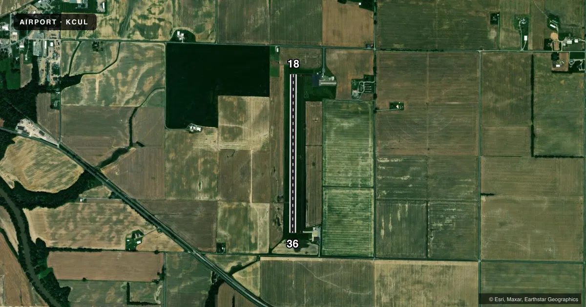
Airport sketch
Runways drawn to scale from FAA survey coordinates, rendered over satellite imagery. Not for navigation.
Approaches & charts
Services on the field
Fuel grades, oxygen, maintenance, ramp storage and lighting — as declared to the FAA by the airport operator.
Fuel & services
- Fuel
- 100LLA
- Oxygen (bottled)
- Not available
- Oxygen (bulk)
- Not available
- Other services
- AGRI
Ramp & ground
- Transient storage
- Hangar
- Landing fee
- No fee published
- Customs
- Not available
- Lighting schedule
- SEE RMK
- Beacon schedule
- SS-SR
- Beacon
- White / Green (civil land)(WG)
- Wind indicator
- Lighted
- Segmented circle
- Yes
Fuel & FBOs
Cheapest 100LL and Jet A on the field and nearby. Always confirm with the FBO before taxi.
Airport notes
Surface conditions, obstructions, local procedures, lighting outages and other notes published with each FAA cycle.
General notes
- FOR CD CTC EVANSVILLE APCH AT 812-436-4690, WHEN APCH CLSD CTC INDIANAPOLIS ARTCC AT 317-247-2411.
Lighting notes
- MIRL RY 18/36 PRESET ON LOW INTST; TO INCR INTST & ACTVT PAPI RYS 18 & 36 AND REIL RY 36- CTAF.
Other notes
- 2CLSD FEDERAL HOLIDAYS.
VFR map & nearby airports
VFR sectional. Tap any ICAO chip to open that airport.
Key facts · KCUL
Answer card- ICAO
- KCUL
- Name
- CARMI MUNI
- Location
- CARMI, ILLINOIS
- Elevation
- 387.9 ft MSL
- Traffic pattern altitude
- 1,387.9 ft MSL (1,000 AGL)
- Control tower
- Non-towered (use CTAF)
- Total runways
- 1
- Longest runway
- 18/36 · 4,000 ft
- Published ILS approaches
- 0
- Published frequencies
- 4
- Magnetic variation
- 1°
- Current flight rules
- VFR
- Current wind
- 140° at 9 kt
- Favored runway now
- RWY 18
Carmi Muni sits in Carmi, Illinois. The field elevation is 387.9 ft MSL. It has one runway, 18/36, which is 4,000 ft long and asphalt. There is no control tower. No ILS approaches are published here.
Pattern altitude is not published. Use 1,000 ft AGL as the standard light piston pattern unless the current Chart Supplement says otherwise. The airport uses CTAF 122.8 for local traffic. Evansville Approach handles clearance delivery at 127.35 and 343.7. If approach is closed, contact Indianapolis ARTCC. The airport is closed on federal holidays.
The on-field FBO is Carmi Municipal Airport. It carries 100LL and Jet A. Call ahead at (618) 380-4211 for current service status before you go. Runway lighting on 18/36 is medium intensity and starts at low intensity. Use the CTAF to raise intensity. That also activates the PAPI on runways 18 and 36. Runway end identifier lights on runway 36 also come on that way. For a first-time arrival, the main things to plan for are the non-towered pattern. Plan for the published lighting setup. You will also be dealing with Evansville Approach for clearance work rather than a local tower.