METAR & TAF 3EV
3EV does not publish a METAR.
Showing the nearest reporting station: KEVV (EVANSVILLE RGNL) · 3.6 NM away. Conditions at 3EV may differ.
METAR · KEVV
Observed 10:54Z
KEVV 271054Z 26007KT 10SM CLR 22/20 A2991 RMK AO2 LTG DSNT SW SLP124 T02220200 $
- Wind
- 260° @ 7 kt
- Visibility
- 10 SM
- Temp / Dew
- 22°C / 20°C
- Altimeter
- 29.91 inHg
- Clouds
- CLR
- Density alt
- 1,324 ft
- Ceiling
- Unlimited
- Rules
- VFR
Airport info & contacts
Manager on record, flight service, ARTCC, attendance schedule and pattern altitude — published by the FAA and refreshed every 28 days.
Location
- From city
- 1 NM NW
- VFR sectional
- ST LOUIS
- ARTCC
- ZID · INDIANAPOLIS
- NOTAM facility
- HUF (NOTAM-D)
Airport manager
- Name
- BRUCE EPMEIER
- Phone
- (812) 480-2152
- Address
- 2029 ALLENS LANE, EVANSVILLE IN 47720
Flight service · Hours
- FSS HUF
- TERRE HAUTE1-800-WX-BRIEF
- Attendance
- IREG
Frequencies
Tap any row to copy the frequency to your clipboard.
Runways & pattern
Full pagePattern entry · RWY 18
LEFT TRAFFICRunway end performance
| End | TORA | TODA | ASDA | LDA | VGSI | Approach lights | Obstruction |
|---|---|---|---|---|---|---|---|
| 18 | — | — | — | — | — | — | 60', tree, 1' from thr, 125' R of cntrln |
| 36 | — | — | — | — | — | — | 71', tree, 1' from thr, 100' R of cntrln |
Declared distances in feet. TORA = takeoff run available, TODA = takeoff distance, ASDA = accelerate-stop, LDA = landing distance.
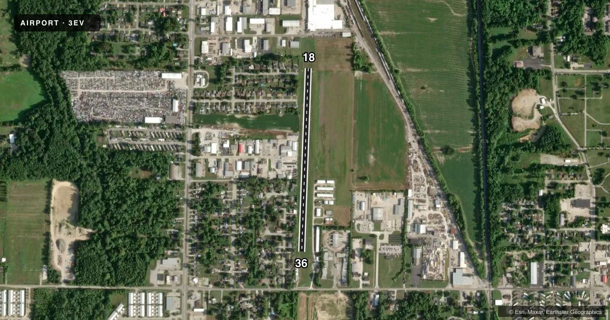
Airport sketch
Runways drawn to scale from FAA survey coordinates, rendered over satellite imagery. Not for navigation.
Approaches & charts
Services on the field
Fuel grades, oxygen, maintenance, ramp storage and lighting — as declared to the FAA by the airport operator.
Fuel & services
- Fuel
- 100LL
- Oxygen (bottled)
- Not available
- Oxygen (bulk)
- Not available
- Airframe repair
- Minor
- Power plant repair
- Minor
Ramp & ground
- Transient storage
- Tie-down
- Landing fee
- No fee published
- Customs
- Not available
- Wind indicator
- Yes
- Segmented circle
- No
Fuel & FBOs
Cheapest 100LL and Jet A on the field and nearby. Always confirm with the FBO before taxi.
Airport notes
Surface conditions, obstructions, local procedures, lighting outages and other notes published with each FAA cycle.
General notes
- TWIN TWRS 1010 FT MSL 8000 FT SOUTH.
- COORDINATE INGRESS/EGRESS WITH EVV APCH/DEP CTL .
- FOR CD CTC EVANSVILLE APCH AT 812-436-4690, WHEN APCH CLSD CTC INDIANAPOLIS ARTCC AT 317-247-2411.
Runway surface & condition
- 18/36RWY USE AT NIGHT NA.
- 18/36400 FT STOPWAY NORTH END; 500 FT STOPWAY SOUTH END.
Approach & departure obstructions
- 18MKD WITH L SHAPED MATS PAINTED WHITE.
- 36MKD WITH L SHAPED MATS PAINTED WHITE.
- 1830 FT BLDGS ON CNTLN 600 FT FM THR.
Other notes
- EXISTED PRIOR TO 1959.
VFR map & nearby airports
VFR sectional. Tap any ICAO chip to open that airport.
Key facts · 3EV
Answer card- ICAO
- 3EV
- Name
- SKYLANE
- Location
- EVANSVILLE, INDIANA
- Elevation
- 380 ft MSL
- Traffic pattern altitude
- 1,380 ft MSL (1,000 AGL)
- Control tower
- Non-towered (use CTAF)
- Total runways
- 1
- Longest runway
- 18/36 · 2,227 ft
- Published ILS approaches
- 0
- Published frequencies
- 1
- Magnetic variation
- 0°
- Current flight rules
- VFR
- Current wind
- 260° at 7 kt
- Favored runway now
- RWY 18
SKYLANE is in Evansville, Indiana. Field elevation is 380 ft MSL. The airport has one runway, 18/36 and it is 2,227 ft of turf. There is no control tower. CTAF is 122.9. No ILS approaches are published here.
Pattern altitude is not published. Use 1,000 ft AGL for light piston traffic unless the current Chart Supplement or the airport operator gives you something different. The field sits in a busy part of the Evansville area. Published remarks call out twin towers 8,000 feet south at 1,010 ft MSL. They also note that runway use at night is not authorized. Runway 18 has white L-shaped mats. Runway 36 has the same marking. There is a 400 foot stopway at the north end. There is a 500 foot stopway at the south end.
For fuel, Skylane Pilots Association is on the field. It carries AVGAS 100LL. If you need clearance delivery or departure coordination, the published remarks direct you to Evansville Approach. If approach is closed, contact Indianapolis ARTCC. Pilots should also watch the centerline on runway 18. There are 30 foot buildings 600 feet from the threshold.