METAR & TAF I91
I91 does not publish a METAR.
Showing the nearest reporting station: KEVV (EVANSVILLE RGNL) · 10.0 NM away. Conditions at I91 may differ.
METAR · KEVV
Observed 05:23Z
KEVV 270523Z AUTO 23009KT 10SM -RA FEW020 BKN065 BKN085 22/22 A2994 RMK AO2 LTG DSNT ALQDS P0000 T02220217 $
- Wind
- 230° @ 9 kt
- Visibility
- 10 SM
- Temp / Dew
- 22°C / 22°C
- Altimeter
- 29.94 inHg
- Clouds
- BKN
- Density alt
- 1,305 ft
- Ceiling
- 6,500 ft AGL
- Rules
- VFR
Airport info & contacts
Manager on record, flight service, ARTCC, attendance schedule and pattern altitude — published by the FAA and refreshed every 28 days.
Location
- From city
- 2 NM W
- VFR sectional
- ST LOUIS
- ARTCC
- ZID · INDIANAPOLIS
- NOTAM facility
- HUF (NOTAM-D)
Airport manager
- Name
- MIKE METZGER
- Phone
- 812-925-7544
- Address
- 655 NORTH CENTER RD, BOONVILLE IN 47601
Flight service · Hours
- FSS HUF
- TERRE HAUTE1-800-WX-BRIEF
- Attendance
- IREG
Frequencies
Tap any row to copy the frequency to your clipboard.
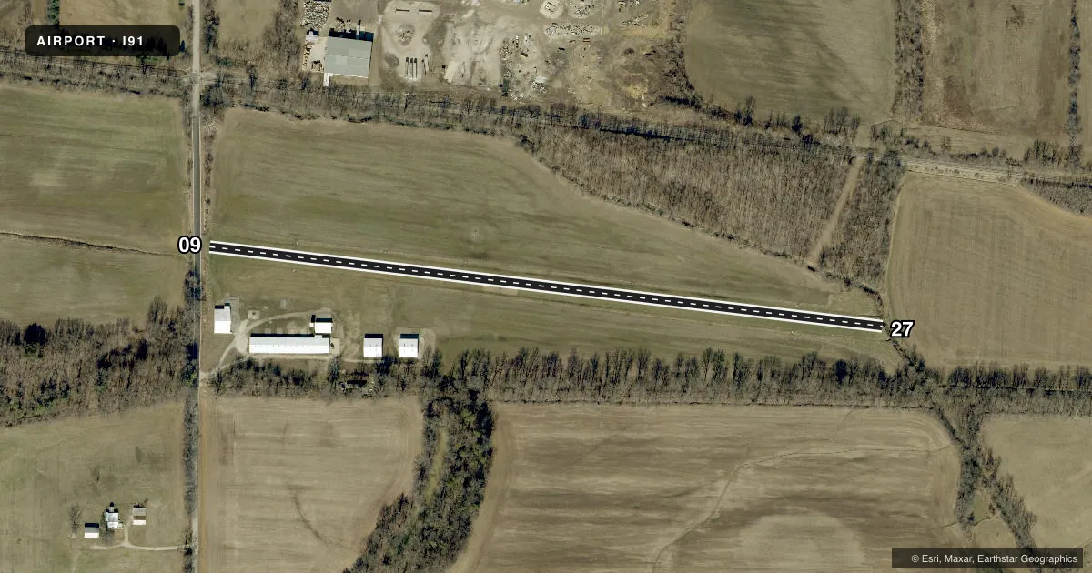
Runways & pattern
Full pagePattern entry · RWY 27
LEFT TRAFFICRunway end performance
| End | TORA | TODA | ASDA | LDA | VGSI | Approach lights | Obstruction |
|---|---|---|---|---|---|---|---|
| 09 | — | — | — | — | — | — | 48', trees, 335' from thr, 130' R of cntrln, slope 6 |
| 27 | — | — | — | — | — | — | 50', trees, 275' from thr, 150' R of cntrln, slope 5 |
Declared distances in feet. TORA = takeoff run available, TODA = takeoff distance, ASDA = accelerate-stop, LDA = landing distance.
Airport sketch
Runways drawn to scale from FAA survey coordinates, rendered over satellite imagery. Not for navigation.
Approaches & charts
Services on the field
Fuel grades, oxygen, maintenance, ramp storage and lighting — as declared to the FAA by the airport operator.
Fuel & services
- Fuel
- Not available
- Oxygen (bottled)
- Not available
- Oxygen (bulk)
- Not available
- Other services
- INSTR,RNTL
Ramp & ground
- Transient storage
- Tie-down
- Hangar
- Landing fee
- No fee published
- Wind indicator
- Yes
Fuel & FBOs
Cheapest 100LL and Jet A on the field and nearby. Always confirm with the FBO before taxi.
Airport notes
Surface conditions, obstructions, local procedures, lighting outages and other notes published with each FAA cycle.
General notes
- DRAINAGE AREAS ALONG RWY BNDRYS HOLD WATER AFTER RAIN.
- UNEVEN TERRAIN FM TURF RY TO GRVL APRON.
- FOR CD CTC EVANSVILLE APCH AT 812-436-4690, WHEN APCH CLSD CTC INDIANAPOLIS ARTCC AT 317-247-2411.
VFR map & nearby airports
VFR sectional. Tap any ICAO chip to open that airport.
Key facts · I91
Answer card- ICAO
- I91
- Name
- BOONVILLE
- Location
- BOONVILLE, INDIANA
- Elevation
- 395 ft MSL
- Traffic pattern altitude
- 1,395 ft MSL (1,000 AGL)
- Control tower
- Non-towered (use CTAF)
- Total runways
- 1
- Longest runway
- 09/27 · 2,300 ft
- Published ILS approaches
- 0
- Published frequencies
- 1
- Magnetic variation
- 0°
- Current flight rules
- VFR
- Current wind
- 230° at 9 kt
- Favored runway now
- RWY 27
Boonville Airport sits in Boonville, Indiana. Field elevation is 395 ft MSL. The airport has one runway. Runway 09/27 is 2,300 ft of turf, which is the longest runway on the field. There is no control tower. CTAF is 122.9.
No ILS approaches are published here. Pattern altitude is not published in the facts, so verify the current traffic pattern altitude before you go. The runway headings are magnetic. Magnetic variation is 0°.
This is a simple turf field, so plan for soft-field technique and a close look at surface condition after rain. The published remarks say drainage areas along the runway boundaries can hold water after rain. They also note uneven terrain from the turf runway to the gravel apron. That makes taxi and parking worth a slow roll, especially after wet weather.
There are no on-field FBOs listed in the facts. Contact the airport operator directly before arrival, or call the field on CTAF for current FBO availability. For clearance delivery, contact Evansville Approach at 812-436-4690. When approach is closed, contact Indianapolis ARTCC at 317-247-2411.