METAR & TAF KEHR
Current METAR
Observed 12:56Z
KEHR 251256Z AUTO 00000KT 10SM OVC055 22/18 A3008 RMK AO2 SLP184 T02170183 $
- Wind
- 000° @ 0 kt
- Visibility
- 10 SM
- Temp / Dew
- 22°C / 18°C
- Altimeter
- 30.08 inHg
- Clouds
- OVC
- Density alt
- 1,121 ft
- Ceiling
- 5,500 ft AGL
- Rules
- VFR
Airport info & contacts
Manager on record, flight service, ARTCC, attendance schedule and pattern altitude — published by the FAA and refreshed every 28 days.
Location
- From city
- 4 NM W
- VFR sectional
- ST LOUIS
- ARTCC
- ZID · INDIANAPOLIS
- NOTAM facility
- EHR (NOTAM-D)
Airport manager
- Name
- EMILY HERRON
- Phone
- 270-724-3040
- Address
- 2154 HWY 136 W., HENDERSON KY 42420
Flight service · Hours
- FSS LOU
- LOUISVILLE1-800-WX-BRIEF
- Attendance
- MON-FRI · 0700-DUSK
- SAT-SUN · 0800-DUSK
Frequencies
Tap any row to copy the frequency to your clipboard.
Runways & pattern
Full pagePattern entry · RWY 09
LEFT TRAFFICRunway end performance
| End | TORA | TODA | ASDA | LDA | VGSI | Approach lights | Obstruction |
|---|---|---|---|---|---|---|---|
| 09 | — | — | — | — | PAPI 4-box left(3°) | — | — |
| 27 | — | — | — | — | PAPI 4-box left(3°) | — | — |
Declared distances in feet. TORA = takeoff run available, TODA = takeoff distance, ASDA = accelerate-stop, LDA = landing distance.
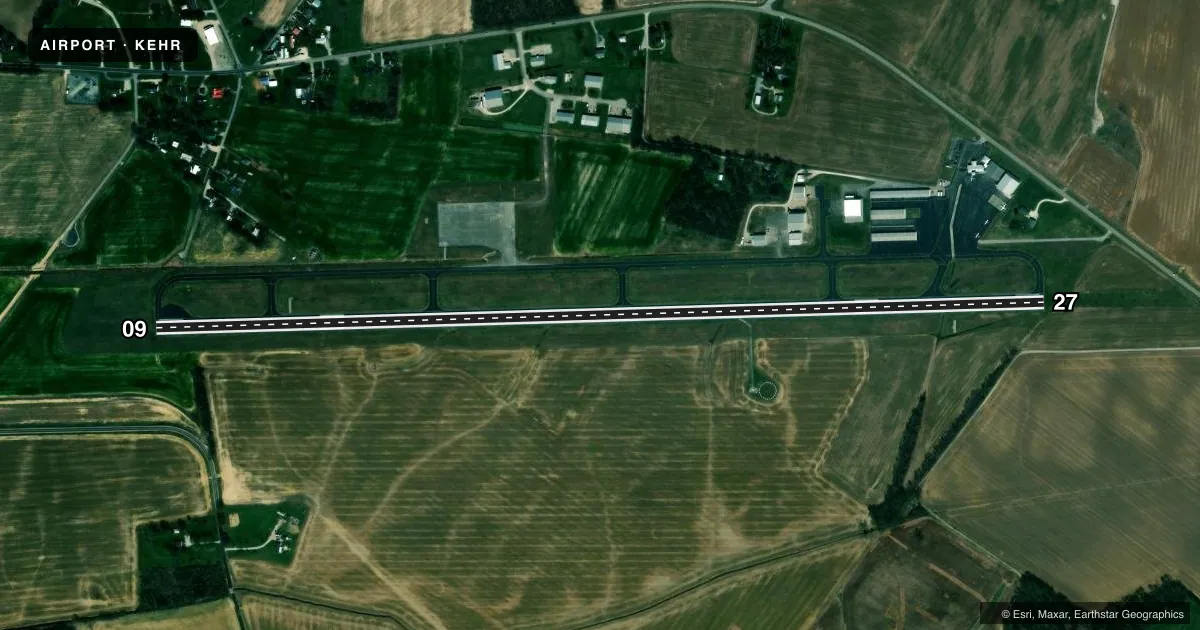
Airport sketch
Runways drawn to scale from FAA survey coordinates, rendered over satellite imagery. Not for navigation.
Approaches & charts
Services on the field
Fuel grades, oxygen, maintenance, ramp storage and lighting — as declared to the FAA by the airport operator.
Fuel & services
- Fuel
- 100LLA+
- Oxygen (bottled)
- High pressure
- Airframe repair
- Major
- Power plant repair
- Minor
- Other services
- CHTR,INSTR,RNTL,SALES
Ramp & ground
- Transient storage
- Tie-down
- Hangar
- Landing fee
- No fee published
- Customs
- Not available
- Lighting schedule
- SEE RMK
- Beacon schedule
- SS-SR
- Beacon
- White / Green (civil land)(WG)
- Wind indicator
- Lighted
- Segmented circle
- Yes
Fuel & FBOs
Cheapest 100LL and Jet A on the field and nearby. Always confirm with the FBO before taxi.
Airport notes
Surface conditions, obstructions, local procedures, lighting outages and other notes published with each FAA cycle.
General notes
- FOR CD CTC EVANSVILLE APCH AT 812-436-4690, WHEN APCH CLSD CTC INDIANAPOLIS ARTCC AT 317-247-2411.
Lighting notes
- MIRL RY 09/27 PRESET LOW INTST; TO INCR INTST & ACTVT REIL RY 09/27; PAPI RY 09/ 27; MIRL RY 9/27- CTAF.
Fuel notes
- 100LLFOR SVC AFTER HRS CALL 270-826-6000.
Other notes
- THIS AIRPORT HAS BEEN SURVEYED BY THE NATIONAL GEODETIC SURVEY.
- EXISTED PRIOR TO 1959.
- OWNERAIRPORT CHAIRMAN- DORIN LUCK
- MANAGERADDL PHONE 270-577-1444
VFR map & nearby airports
VFR sectional. Tap any ICAO chip to open that airport.
Key facts · KEHR
Answer card- ICAO
- KEHR
- Name
- HENDERSON CITY-COUNTY
- Location
- HENDERSON, KENTUCKY
- Elevation
- 386.7 ft MSL
- Traffic pattern altitude
- 1,386.7 ft MSL (1,000 AGL)
- Control tower
- Non-towered (use CTAF)
- Total runways
- 1
- Longest runway
- 09/27 · 5,503 ft
- Published ILS approaches
- 0
- Published frequencies
- 4
- Magnetic variation
- 1°
- Current flight rules
- VFR
- Current wind
- 000° at 0 kt
- Favored runway now
- –
Henderson City-County Airport sits in Henderson, Kentucky. The field elevation is 386.7 ft MSL. It has one runway, 09/27, which is 5,503 ft long. There is no control tower. No ILS approaches are published here.
The pattern altitude is not published in the facts. Use the standard 1,000 ft AGL for light piston traffic unless the current Chart Supplement says otherwise. That puts the pattern at 1,386.7 ft MSL based on the field elevation. Runway 09/27 has medium intensity lights that come up in low intensity by default. Use the CTAF to raise intensity and activate the runway end identifier lights. A PAPI is available on runway 09/27.
Don Davis Aviation is on the field. It carries 100LL and Jet A. Call ahead for after-hours fuel service if needed. CTAF and UNICOM are both 122.8. For clearance delivery, contact Evansville Approach. If approach is closed, use Indianapolis ARTCC. First-time visitors should plan for a non-towered field with a single asphalt runway and no published ILS. Check current procedures before arrival, especially if you need IFR support or after-hours service.