METAR & TAF KTWT
Current METAR
Observed 12:15Z
KTWT 271215Z AUTO 07003KT 10SM CLR 22/21 A2990 RMK AO2 T02220206
- Wind
- 070° @ 3 kt
- Visibility
- 10 SM
- Temp / Dew
- 22°C / 21°C
- Altimeter
- 29.90 inHg
- Clouds
- CLR
- Density alt
- 1,326 ft
- Ceiling
- Unlimited
- Rules
- VFR
Airport info & contacts
Manager on record, flight service, ARTCC, attendance schedule and pattern altitude — published by the FAA and refreshed every 28 days.
Location
- From city
- 2 NM E
- VFR sectional
- ST LOUIS
- ARTCC
- ZID · INDIANAPOLIS
- NOTAM facility
- LOU (NOTAM-D)
Airport manager
- Name
- KYLE BAIRD
- Phone
- 270-952-4519
- Address
- MUNICIPAL ARPT, BOX 381, STURGIS KY 42459
Flight service · Hours
- FSS LOU
- LOUISVILLE1-800-WX-BRIEF
- Attendance
- 0700-1700
Frequencies
Tap any row to copy the frequency to your clipboard.
Runways & pattern
Full pagePattern entry · RWY 01
LEFT TRAFFICRunway end performance
| End | TORA | TODA | ASDA | LDA | VGSI | Approach lights | Obstruction |
|---|---|---|---|---|---|---|---|
| 01 | — | — | — | — | PAPI 4-box left(3°) | — | 66', trees, 1635' from thr, 421' R of cntrln, slope 21 |
| 19 | — | — | — | — | PAPI 4-box left(3.5°) | — | — |
Declared distances in feet. TORA = takeoff run available, TODA = takeoff distance, ASDA = accelerate-stop, LDA = landing distance.
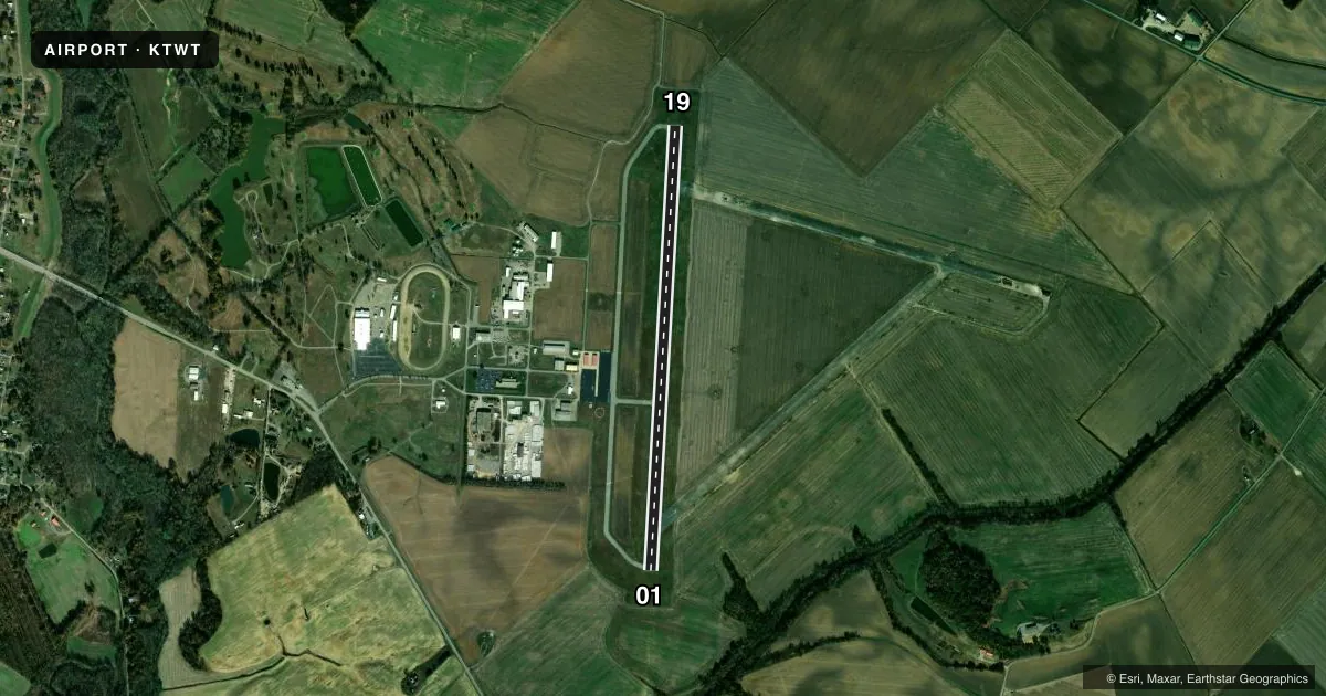
Airport sketch
Runways drawn to scale from FAA survey coordinates, rendered over satellite imagery. Not for navigation.
Approaches & charts
Services on the field
Fuel grades, oxygen, maintenance, ramp storage and lighting — as declared to the FAA by the airport operator.
Fuel & services
- Fuel
- 100LLA+
- Oxygen (bulk)
- HIGH/LOW
- Airframe repair
- Major
- Power plant repair
- Major
- Other services
- AGRI,INSTR,RNTL
Ramp & ground
- Transient storage
- Tie-down
- Hangar
- Landing fee
- No fee published
- Customs
- Not available
- Lighting schedule
- SEE RMK
- Beacon schedule
- SS-SR
- Beacon
- White / Green (civil land)(WG)
- Wind indicator
- Lighted
- Segmented circle
- Yes
Fuel & FBOs
Cheapest 100LL and Jet A on the field and nearby. Always confirm with the FBO before taxi.
Airport notes
Surface conditions, obstructions, local procedures, lighting outages and other notes published with each FAA cycle.
General notes
- FOR CD CTC EVANSVILLE APCH AT 812-436-4690, WHEN APCH CLSD CTC INDIANAPOLIS ARTCC AT 317-247-2411.
Lighting notes
- ACTV REIL RWY 01 & 19; PAPI RWY 01 & 19; MIRL RWY 1/19 - CTAF.
Fuel notes
- 100LLAVBL H24 WITH CREDIT CARD.
- A+AVBL H24 WITH CREDIT CARD.
Other notes
- VFR ONLY
- MANAGERAFT HRS CALL AMGR CELL 270-952-4519.
- OWNERFBO LANDLINE
VFR map & nearby airports
VFR sectional. Tap any ICAO chip to open that airport.
Key facts · KTWT
Answer card- ICAO
- KTWT
- Name
- STURGIS MUNI
- Location
- STURGIS, KENTUCKY
- Elevation
- 372.2 ft MSL
- Traffic pattern altitude
- 1,372.2 ft MSL (1,000 AGL)
- Control tower
- Non-towered (use CTAF)
- Total runways
- 1
- Longest runway
- 01/19 · 5,000 ft
- Published ILS approaches
- 0
- Published frequencies
- 4
- Magnetic variation
- 0°
- Current flight rules
- VFR
- Current wind
- 070° at 3 kt
- Favored runway now
- RWY 01
Sturgis Muni sits in Sturgis, Kentucky at 372.2 ft MSL. It has one runway, 01/19, which is 5,000 ft of asphalt. The field is non-towered. Pattern altitude is not published, so light piston pilots should plan on the standard 1,000 ft AGL unless the current Chart Supplement says otherwise.
No ILS approaches are published here. The airport is VFR only per the published remarks. Runway 01 and 19 have runway end identifier lights, PAPI and medium intensity runway lighting. That helps at night, but you still need to verify current conditions before you go.
Sturgis Municipal Airport is the on-field FBO. It carries 100LL and Jet A. Published remarks also say 100LL is available 24 hours a day with credit card. After hours, call the airport manager’s cell phone. For clearance delivery, contact Evansville Approach. When approach is closed, use Indianapolis ARTCC. The CTAF and UNICOM are both 122.8.
This is a small field with no tower. Expect self-announce traffic and watch your spacing. If you need noise or operating restrictions beyond the published remarks, check the current FAA Chart Supplement before departure.