METAR & TAF 2I0
Current METAR
Observed 10:15Z
K2I0 271015Z AUTO 00000KT 10SM SCT120 21/20 A2993 RMK AO2 T02120197
- Wind
- 000° @ 0 kt
- Visibility
- 10 SM
- Temp / Dew
- 21°C / 20°C
- Altimeter
- 29.93 inHg
- Clouds
- SCT
- Density alt
- 1,252 ft
- Ceiling
- Unlimited
- Rules
- VFR
Airport info & contacts
Manager on record, flight service, ARTCC, attendance schedule and pattern altitude — published by the FAA and refreshed every 28 days.
Location
- From city
- 5 NM NE
- VFR sectional
- ST LOUIS
- ARTCC
- ZID · INDIANAPOLIS
- NOTAM facility
- LOU (NOTAM-D)
Airport manager
- Name
- VICTORIA DAVENPORT
- Phone
- 270-836-8111
- Address
- 162 AIRPORT ROAD, MADISONVILLE KY 42431
Flight service · Hours
- FSS LOU
- LOUISVILLE1-800-WX-BRIEF
- Attendance
- HOLIDAY · CLSD
- MON-SAT · 0800-1700
- SUN · CLSD
Frequencies
Tap any row to copy the frequency to your clipboard.
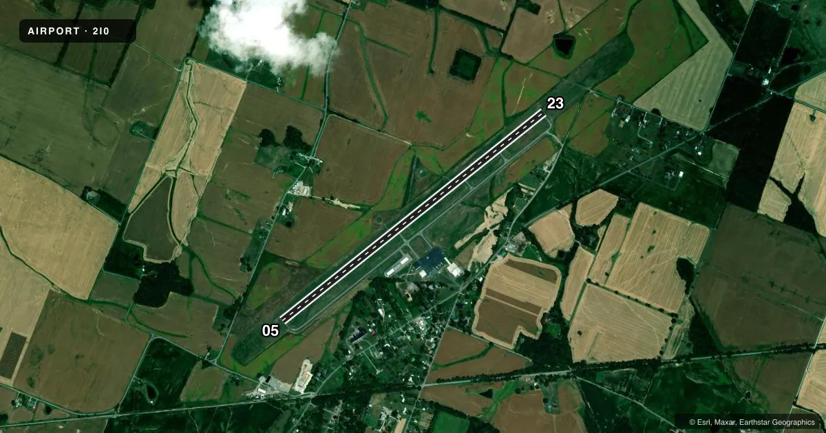
Runways & pattern
Full pagePattern entry · RWY 05
LEFT TRAFFICRunway end performance
| End | TORA | TODA | ASDA | LDA | VGSI | Approach lights | Obstruction |
|---|---|---|---|---|---|---|---|
| 05 | — | — | — | — | PAPI 4-box right(3°) | — | 61', trees, 1321' from thr, 396' R of cntrln, slope 18 |
| 23 | — | — | — | — | PAPI 4-box left(3°) | ODALS | — |
Declared distances in feet. TORA = takeoff run available, TODA = takeoff distance, ASDA = accelerate-stop, LDA = landing distance.
Airport sketch
Runways drawn to scale from FAA survey coordinates, rendered over satellite imagery. Not for navigation.
Approaches & charts
Services on the field
Fuel grades, oxygen, maintenance, ramp storage and lighting — as declared to the FAA by the airport operator.
Fuel & services
- Fuel
- 100LLA+
- Other services
- INSTR,RNTL
Ramp & ground
- Transient storage
- Tie-down
- Hangar
- Landing fee
- No fee published
- Customs
- Not available
- Lighting schedule
- SEE RMK
- Beacon schedule
- SS-SR
- Beacon
- White / Green (civil land)(WG)
- Wind indicator
- Lighted
- Segmented circle
- Yes
Fuel & FBOs
Cheapest 100LL and Jet A on the field and nearby. Always confirm with the FBO before taxi.
Airport notes
Surface conditions, obstructions, local procedures, lighting outages and other notes published with each FAA cycle.
General notes
- FOR CD WHEN RCO 120.1 OTS CTC EVANSVILLE APCH AT 812-436-4689, WHEN APCH CLSD CTC INDIANAPOLIS ARTCC AT 317-247-2411.
Lighting notes
- ACTVT ODALS RWY 23; REIL RWY 05; HIRL RWY 05/23 - CTAF. HIRL RWY 05/23 PRESET LOW INTST; INCR INTST - CTAF.
Other notes
- MANAGERAFT HR - 270-871-5743.
VFR map & nearby airports
VFR sectional. Tap any ICAO chip to open that airport.
Key facts · 2I0
Answer card- ICAO
- 2I0
- Name
- MADISONVILLE RGNL
- Location
- MADISONVILLE, KENTUCKY
- Elevation
- 439.1 ft MSL
- Traffic pattern altitude
- 1,439.1 ft MSL (1,000 AGL)
- Control tower
- Non-towered (use CTAF)
- Total runways
- 1
- Longest runway
- 05/23 · 6,051 ft
- Published ILS approaches
- 0
- Published frequencies
- 5
- Magnetic variation
- 3°
- Current flight rules
- VFR
- Current wind
- 000° at 0 kt
- Favored runway now
- –
Madisonville Rgnl sits in Madisonville, Kentucky. The field elevation is 439.1 ft MSL. It has one runway. Runway 05/23 is 6,051 ft long with asphalt pavement. There is no control tower. Pattern altitude is not published, so use 1,000 ft AGL for light piston traffic unless the current Chart Supplement says otherwise.
No ILS approaches are published here. The airport uses CTAF 122.7 and UNICOM 122.7. Clearance delivery is on 120.1 when the remote communications outlet is up. Evansville Approach uses 124.025 and 290.9. If the RCO is out of service, the published remarks say to contact Evansville Approach by phone. If approach is closed, contact Indianapolis ARTCC by phone.
Madisonville Municipal Airport is the on-field FBO. It carries 100LL and Jet A. After hours, the published remarks list a manager contact number. The runway lighting setup is worth planning for at night. Runway 23 has an omnidirectional approach lighting system. Runway 05 has REILs. High intensity runway lights are on both ends. They are controlled by CTAF and start at low intensity. Ask for more intensity on CTAF if needed.
For a first visit, watch the non-towered pattern work and confirm lighting or comms status before you launch. The field is in western Kentucky with modest elevation, so terrain is not the main issue. Radio discipline and runway setup are the bigger items here.