METAR & TAF KJQD
KJQD does not publish a METAR.
Showing the nearest reporting station: KOWB (OWENSBORO/DAVIESS COUNTY RGNL) · 22.6 NM away. Conditions at KJQD may differ.
METAR · KOWB
Observed 09:56Z
KOWB 270956Z AUTO 27006KT 10SM CLR 22/22 A2992 RMK AO2 SLP127 T02170217
- Wind
- 270° @ 6 kt
- Visibility
- 10 SM
- Temp / Dew
- 22°C / 22°C
- Altimeter
- 29.92 inHg
- Clouds
- CLR
- Density alt
- 1,506 ft
- Ceiling
- Unlimited
- Rules
- VFR
Airport info & contacts
Manager on record, flight service, ARTCC, attendance schedule and pattern altitude — published by the FAA and refreshed every 28 days.
Location
- From city
- 3 NM NE
- VFR sectional
- ST LOUIS
- ARTCC
- ZID · INDIANAPOLIS
- NOTAM facility
- LOU (NOTAM-D)
Airport manager
- Name
- DAVID WOOSLEY
- Phone
- 270-993-0867
- Address
- 340 AIRPORT ROAD, HARTFORD KY 42347
Flight service · Hours
- FSS LOU
- LOUISVILLE1-800-WX-BRIEF
- Attendance
- MON - FRI · 0900-1700
Frequencies
Tap any row to copy the frequency to your clipboard.
Runways & pattern
Full pagePattern entry · RWY 21
LEFT TRAFFICRunway end performance
| End | TORA | TODA | ASDA | LDA | VGSI | Approach lights | Obstruction |
|---|---|---|---|---|---|---|---|
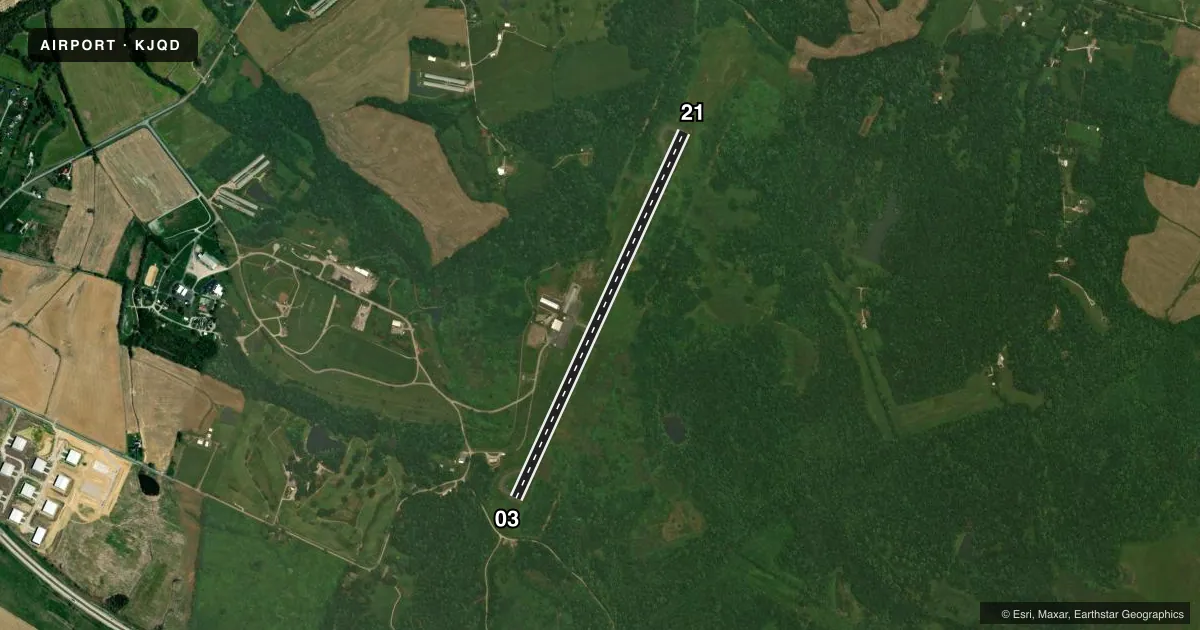
| 03 | — | — | — | — | PAPI 2-box left(3°) | — | 25', trees, 227' from thr, 235' R of cntrln, slope 1 |
| 21 | — | — | — | — | PAPI 2-box left(3.5°) | — | 57', trees, 828' from thr, 276' R of cntrln, slope 11 |
Declared distances in feet. TORA = takeoff run available, TODA = takeoff distance, ASDA = accelerate-stop, LDA = landing distance.
Airport sketch
Runways drawn to scale from FAA survey coordinates, rendered over satellite imagery. Not for navigation.
Approaches & charts
Services on the field
Fuel grades, oxygen, maintenance, ramp storage and lighting — as declared to the FAA by the airport operator.
Fuel & services
- Fuel
- 100LL
- Oxygen (bulk)
- Not available
- Airframe repair
- Major
- Power plant repair
- Major
Ramp & ground
- Transient storage
- Tie-down
- Hangar
- Landing fee
- No fee published
- Lighting schedule
- SEE RMK
- Beacon schedule
- SS-SR
- Beacon
- White / Green (civil land)(WG)
- Wind indicator
- Lighted
- Segmented circle
- Yes
Fuel & FBOs
Cheapest 100LL and Jet A on the field and nearby. Always confirm with the FBO before taxi.
Airport notes
Surface conditions, obstructions, local procedures, lighting outages and other notes published with each FAA cycle.
General notes
- FOR CD CTC EVANSVILLE APCH AT 812-436-4690, WHEN APCH CLSD CTC INDIANAPOLIS ARTCC AT 317-247-2411.
Lighting notes
- DUSK-DAWN ACTVT PAPI RWY 03 & 21; MIRL RWY 03/21 - CTAF.
Approach & departure obstructions
- 0311 FT TREE 184 FT BYD THR 211 FT R OF CNTRLN.
Other notes
- 1SVC AFT HR - AMGR.
VFR map & nearby airports
VFR sectional. Tap any ICAO chip to open that airport.
Key facts · KJQD
Answer card- ICAO
- KJQD
- Name
- OHIO COUNTY
- Location
- HARTFORD, KENTUCKY
- Elevation
- 537 ft MSL
- Traffic pattern altitude
- 1,537 ft MSL (1,000 AGL)
- Control tower
- Non-towered (use CTAF)
- Total runways
- 1
- Longest runway
- 03/21 · 5,003 ft
- Published ILS approaches
- 0
- Published frequencies
- 4
- Magnetic variation
- 2°
- Current flight rules
- VFR
- Current wind
- 270° at 6 kt
- Favored runway now
- RWY 21
Ohio County Airport sits in Hartford, Kentucky. The field elevation is 537 ft MSL. It has one runway, 03/21, which is 5,003 ft long. There is no control tower. No ILS approaches are published. The pattern altitude is not published, so verify the current Chart Supplement before you fly. The airport sits in a non-towered environment with approach support from Evansville. Clearance delivery is handled through Evansville Approach when it is open. When approach is closed, contact Indianapolis ARTCC.
For local fuel and ramp needs, Leading Edge Aircraft Services is on the field. It carries 100LL and Jet A Prist. Service after hours is available from the airport manager. Runway 03 has an 11-foot tree 184 feet beyond the threshold and 211 feet right of centerline, so plan your arrival path with that in mind. From dusk to dawn, the PAPI on runways 03 and 21 is active. Medium intensity runway lights on both runways operate on CTAF. For a first-time arrival, the main things to brief are the non-towered pattern, the published lighting setup and the obstruction near runway 03. Check the current Chart Supplement for any noise or curfew restrictions before flying into the field.