METAR & TAF 2I3
2I3 does not publish a METAR.
Showing the nearest reporting station: KEKX (ADDINGTON FLD) · 28.0 NM away. Conditions at 2I3 may differ.
METAR · KEKX
Observed 06:15Z
KEKX 270615Z AUTO 00000KT 10SM SCT048 23/23 A2992 RMK AO2 T02300225
- Wind
- 000° @ 0 kt
- Visibility
- 10 SM
- Temp / Dew
- 23°C / 23°C
- Altimeter
- 29.92 inHg
- Clouds
- SCT
- Density alt
- 1,674 ft
- Ceiling
- Unlimited
- Rules
- VFR
Airport info & contacts
Manager on record, flight service, ARTCC, attendance schedule and pattern altitude — published by the FAA and refreshed every 28 days.
Location
- From city
- 3 NM NE
- VFR sectional
- ST LOUIS
- ARTCC
- ZID · INDIANAPOLIS
- NOTAM facility
- LOU (NOTAM-D)
Airport manager
- Name
- MICHAEL RICKS
- Phone
- 270-257-2311
- Address
- 450 LODGE ROAD, FALLS OF ROUGH KY 40119
Flight service · Hours
- FSS LOU
- LOUISVILLE1-800-WX-BRIEF
- Attendance
- Unattended
Frequencies
Tap any row to copy the frequency to your clipboard.
Runways & pattern
Full pagePattern entry · RWY 02
LEFT TRAFFICRunway end performance
| End | TORA | TODA | ASDA | LDA | VGSI | Approach lights | Obstruction |
|---|---|---|---|---|---|---|---|
| 02 | — | — | — | — | PAPI 2-box left(4°) | — | 25', trees, 500' from thr, 85' R of cntrln, slope 12 |
| 20 | — | — | — | — | PAPI 4-box left(5°) | — | 251', trees, 4827' from thr, 392' R of cntrln, slope 18 |
Declared distances in feet. TORA = takeoff run available, TODA = takeoff distance, ASDA = accelerate-stop, LDA = landing distance.
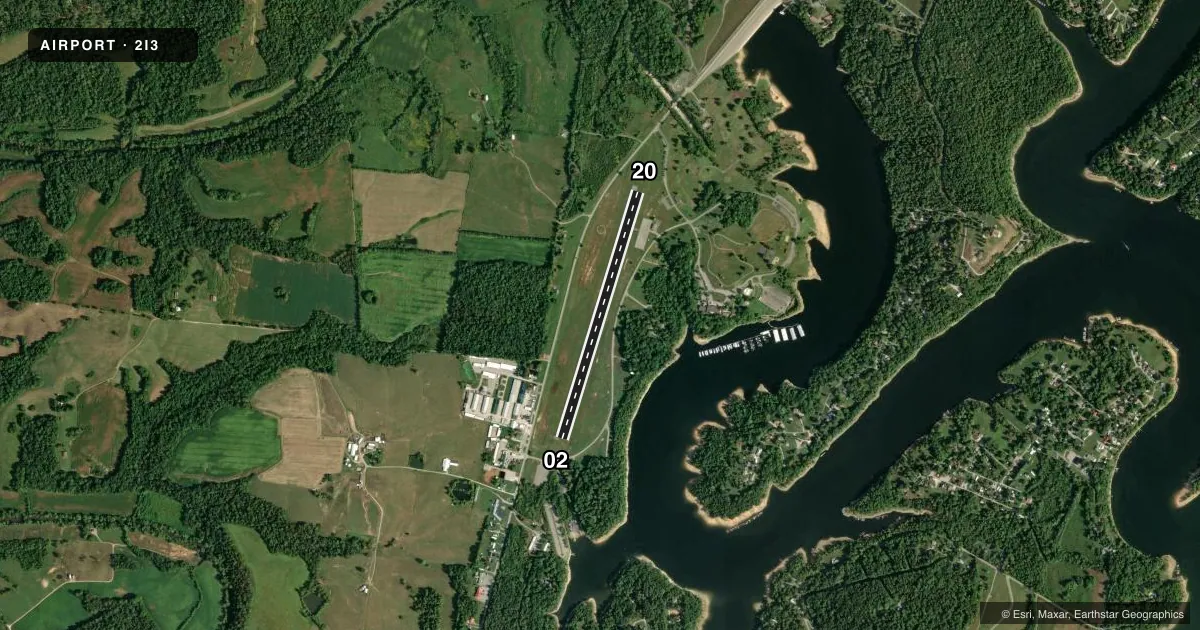
Airport sketch
Runways drawn to scale from FAA survey coordinates, rendered over satellite imagery. Not for navigation.
Approaches & charts
Services on the field
Fuel grades, oxygen, maintenance, ramp storage and lighting — as declared to the FAA by the airport operator.
Fuel & services
- Fuel
- Not available
Ramp & ground
- Transient storage
- Tie-down
- Landing fee
- No fee published
- Customs
- Not available
- Lighting schedule
- SEE RMK
- Beacon schedule
- SS-SR
- Beacon
- White / Green (civil land)(WG)
- Wind indicator
- Lighted
- Segmented circle
- Yes
Fuel & FBOs
Cheapest 100LL and Jet A on the field and nearby. Always confirm with the FBO before taxi.
Airport notes
Surface conditions, obstructions, local procedures, lighting outages and other notes published with each FAA cycle.
General notes
- TRNSPN TO LODGE - AMG.
- FOR CD CTC LOUISVILLE APCH AT 502-375-7499.
Lighting notes
- ACTVT REIL RWY 02 & 20; MIRL RWY 02/20 - CTAF. PAPI RWY 02 & 20 OPR CONSLY.
VFR map & nearby airports
VFR sectional. Tap any ICAO chip to open that airport.
Key facts · 2I3
Answer card- ICAO
- 2I3
- Name
- ROUGH RIVER STATE PARK
- Location
- FALLS-OF-ROUGH, KENTUCKY
- Elevation
- 575.9 ft MSL
- Traffic pattern altitude
- 1,575.9 ft MSL (1,000 AGL)
- Control tower
- Non-towered (use CTAF)
- Total runways
- 1
- Longest runway
- 02/20 · 3,200 ft
- Published ILS approaches
- 0
- Published frequencies
- 4
- Magnetic variation
- 1°
- Current flight rules
- VFR
- Current wind
- 000° at 0 kt
- Favored runway now
- –
Rough River State Park Airport sits in Falls-of-Rough, Kentucky. The field elevation is 575.9 ft MSL. It has one runway. Runway 02/20 is 3,200 ft long and asphalt. The airport is not towered. Pattern altitude is not published, so use the standard 1,000 ft AGL for light piston operations unless the current Chart Supplement says otherwise.
There are no published ILS approaches here. CTAF and UNICOM are both 122.8. Louisville Approach uses 123.675 and 327.0 for approach and departure. For clearance delivery, the published remark says to contact Louisville Approach at 502-375-7499. The runway lighting is pilot-controlled on CTAF. Runway end identifier lights are also available on 02 and 20. Precision approach path indicators operate continuously on both ends.
No on-field FBOs are listed. Plan on self-sufficiency and verify services with the airport operator or the FBO directly by phone before you go. The published remarks also note transportation to the lodge is available by AMG. For a first visit, pay attention to the lighting setup and the local terrain around the lake and park area. Check the current FAA Chart Supplement for any noise or curfew restrictions before flying into the field.