METAR & TAF M20
M20 does not publish a METAR.
Showing the nearest reporting station: KEKX (ADDINGTON FLD) · 23.5 NM away. Conditions at M20 may differ.
METAR · KEKX
Observed 11:55Z
KEKX 271155Z AUTO 00000KT 7SM SCT003 22/22 A2994 RMK AO2 70043 T02200220 10231 20210
- Wind
- 000° @ 0 kt
- Visibility
- 7 SM
- Temp / Dew
- 22°C / 22°C
- Altimeter
- 29.94 inHg
- Clouds
- SCT
- Density alt
- 1,785 ft
- Ceiling
- Unlimited
- Rules
- VFR
Airport info & contacts
Manager on record, flight service, ARTCC, attendance schedule and pattern altitude — published by the FAA and refreshed every 28 days.
Location
- From city
- 4 NM SE
- VFR sectional
- ST LOUIS
- ARTCC
- ZID · INDIANAPOLIS
- NOTAM facility
- LOU (NOTAM-D)
Airport manager
- Name
- MICHAEL PIERCE
- Phone
- 502-379-0810
- Address
- 427 SOUTH LANE, LEITCHFIELD KY 42754
Flight service · Hours
- FSS LOU
- LOUISVILLE1-800-WX-BRIEF
- Attendance
- UNATTENDED
Frequencies
Tap any row to copy the frequency to your clipboard.
Runways & pattern
Full pagePattern entry · RWY 02
LEFT TRAFFICRunway end performance
| End | TORA | TODA | ASDA | LDA | VGSI | Approach lights | Obstruction |
|---|---|---|---|---|---|---|---|
| 02 | — | — | — | 3,800' | PAPI 2-box left(3°) | — | 4', trees, 249' from thr, 67' R of cntrln, slope 12 |
| 20 | — | — | — | — | PAPI 2-box left(3°) | — | 37', road, 875' from thr, 190' R of cntrln, slope 18 |
Declared distances in feet. TORA = takeoff run available, TODA = takeoff distance, ASDA = accelerate-stop, LDA = landing distance.
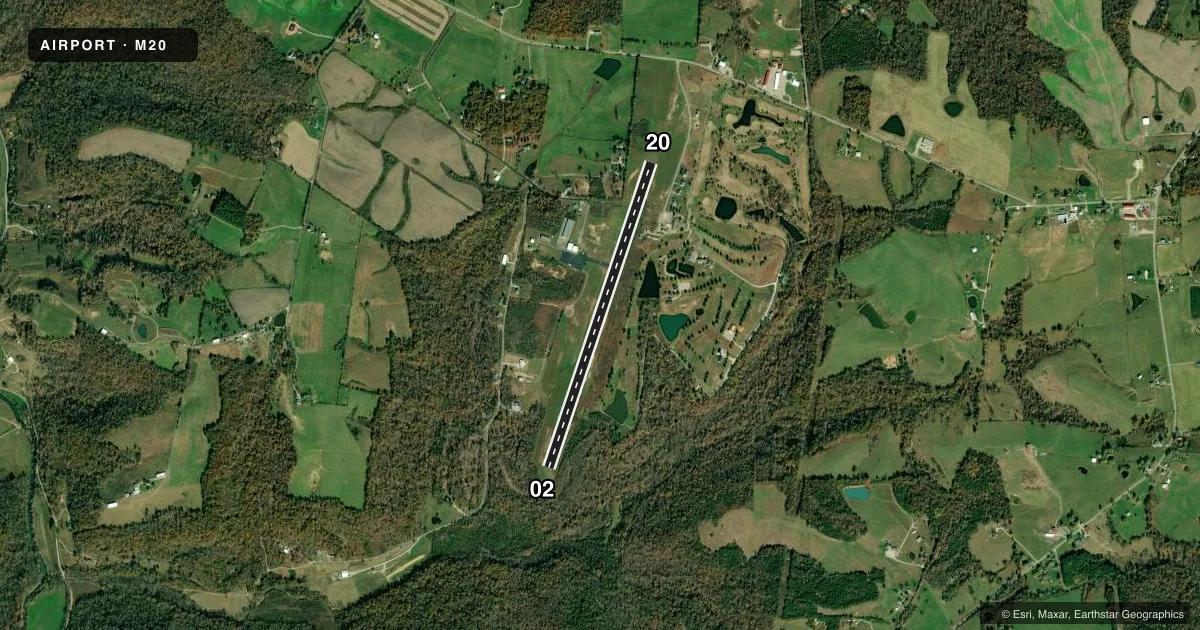
Airport sketch
Runways drawn to scale from FAA survey coordinates, rendered over satellite imagery. Not for navigation.
Approaches & charts
Services on the field
Fuel grades, oxygen, maintenance, ramp storage and lighting — as declared to the FAA by the airport operator.
Fuel & services
- Fuel
- 100LL
Ramp & ground
- Transient storage
- Tie-down
- Landing fee
- No fee published
- Lighting schedule
- SEE RMK
- Beacon schedule
- SEE RMK
- Beacon
- White / Green (civil land)(WG)
- Wind indicator
- Lighted
- Segmented circle
- Yes
Fuel & FBOs
Cheapest 100LL and Jet A on the field and nearby. Always confirm with the FBO before taxi.
Airport notes
Surface conditions, obstructions, local procedures, lighting outages and other notes published with each FAA cycle.
General notes
- FOR CD CTC INDIANAPOLIS ARTCC AT 317-247-2411.
Lighting notes
- ACTVT ROTG BCN - CTAF.
- ACTVT REIL RWY 02 & 20; PAPI RWY 02 & 20; MIRL RWY 02/20 - CTAF.
Fuel notes
- 100LLAVBL H24 WITH CREDIT CARD.
Approach & departure obstructions
- 029 FT TREES 169 FT BYD THR 121 FT R OF CNTRLN.
- 02OBSTN CLNC SLP 20:1 TO DTHR.
Other notes
- VFR OPS ONLY.
- OWNERMICHAEL PIERCE. NEW FONE NR 502-379-0810.
VFR map & nearby airports
VFR sectional. Tap any ICAO chip to open that airport.
Key facts · M20
Answer card- ICAO
- M20
- Name
- LEITCHFIELD-GRAYSON COUNTY
- Location
- LEITCHFIELD, KENTUCKY
- Elevation
- 782 ft MSL
- Traffic pattern altitude
- 1,782 ft MSL (1,000 AGL)
- Control tower
- Non-towered (use CTAF)
- Total runways
- 1
- Longest runway
- 02/20 · 4,000 ft
- Published ILS approaches
- 0
- Published frequencies
- 2
- Magnetic variation
- 4°
- Current flight rules
- VFR
- Current wind
- 000° at 0 kt
- Favored runway now
- –
Leitchfield-Grayson County Airport (M20) sits in Leitchfield, Kentucky. Field elevation is 782 ft MSL. The airport has one runway. Runway 02/20 is 4,000 ft asphalt, which is the longest runway on the field. There is no control tower. CTAF and UNICOM are both 123.0.
No ILS approaches are published here. This is a VFR-only field, so plan your arrival with that in mind. Pattern altitude is not published. Use the standard 1,000 ft AGL pattern unless the current Chart Supplement or local guidance says otherwise. The field is light on published instrument infrastructure, so a first-time pilot should brief a visual arrival and have the airport in sight before descending into the pattern.
Grayson County Airport is on field and carries 100LL. The remarks say 100LL is available 24 hours a day with a credit card. The runway lighting is CTAF-activated. That includes the rotating beacon, runway end identifier lights and medium intensity runway lights on 02/20. Precision approach path indicators are installed on both runway ends. Be aware of the published obstruction near runway 02. There are 9 ft trees 169 ft beyond the threshold and 121 ft right of centerline. The remarks also note a 20 to 1 obstacle clearance slope to the displaced threshold on runway 02. For clearance delivery, contact Indianapolis ARTCC.