METAR & TAF KY8
Current METAR
Observed 09:35Z
KKY8 270935Z AUTO 24007KT 10SM CLR 23/22 A2991 RMK A01
- Wind
- 240° @ 7 kt
- Visibility
- 10 SM
- Temp / Dew
- 23°C / 22°C
- Altimeter
- 29.91 inHg
- Clouds
- CLR
- Density alt
- 1,483 ft
- Ceiling
- Unlimited
- Rules
- VFR
Airport info & contacts
Manager on record, flight service, ARTCC, attendance schedule and pattern altitude — published by the FAA and refreshed every 28 days.
Location
- From city
- 3 NM NE
- VFR sectional
- ST LOUIS
- ARTCC
- ZID · INDIANAPOLIS
- NOTAM facility
- LOU (NOTAM-D)
Airport manager
- Name
- BILL BAUGHMAN
- Phone
- 270-302-3262
- Address
- 500 AIRPORT ROAD, LEWISPORT KY 42351
Flight service · Hours
- FSS LOU
- LOUISVILLE1-800-WX-BRIEF
- Attendance
- M-F · 0700-1200
Frequencies
Tap any row to copy the frequency to your clipboard.
Runways & pattern
Full pagePattern entry · RWY 23
LEFT TRAFFICRunway end performance
| End | TORA | TODA | ASDA | LDA | VGSI | Approach lights | Obstruction |
|---|---|---|---|---|---|---|---|
| 05 | — | — | — | — | PAPI 4-box left(3.5°) | — | 104', tree, 2759' from thr, 498' R of cntrln, slope 24 |
| 23 | — | — | — | — | PAPI 4-box left(3°) | — | 93', tree, 2104' from thr, 524' R of cntrln, slope 20 |
Declared distances in feet. TORA = takeoff run available, TODA = takeoff distance, ASDA = accelerate-stop, LDA = landing distance.
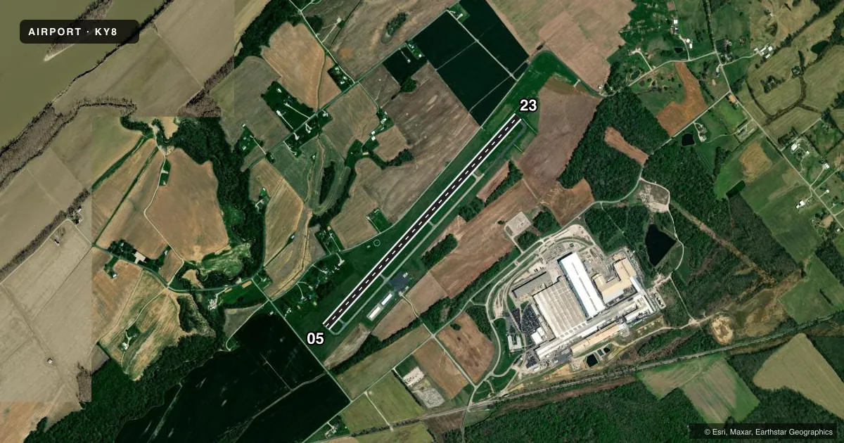
Airport sketch
Runways drawn to scale from FAA survey coordinates, rendered over satellite imagery. Not for navigation.
Approaches & charts
Services on the field
Fuel grades, oxygen, maintenance, ramp storage and lighting — as declared to the FAA by the airport operator.
Fuel & services
- Fuel
- 100LLA+
Ramp & ground
- Transient storage
- Tie-down
- Lighting schedule
- SEE RMK
- Beacon schedule
- SS-SR
- Beacon
- White / Green (civil land)(WG)
- Wind indicator
- Lighted
- Segmented circle
- Yes
Fuel & FBOs
Cheapest 100LL and Jet A on the field and nearby. Always confirm with the FBO before taxi.
Airport notes
Surface conditions, obstructions, local procedures, lighting outages and other notes published with each FAA cycle.
General notes
- FOR CD CTC EVANSVILLE APCH AT 812-436-4690, WHEN APCH CLSD CTC INDIANAPOLIS ARTCC AT 317-247-2411.
- AMGR AVBL BY APNTMT/ PHONE CALL.
Lighting notes
- ACTVT REIL RWY 05 & 23; MIRL RWY 5/23 - CTAF. PAPI RWY 05 & 23 OPR CONSLY.
Fuel notes
- 100LLFUEL AVBL 24/7 WITH CC.
Other notes
- OWNERTIM POWERS
VFR map & nearby airports
VFR sectional. Tap any ICAO chip to open that airport.
Key facts · KY8
Answer card- ICAO
- KY8
- Name
- HANCOCK COUNTY/RON LEWIS FLD
- Location
- LEWISPORT, KENTUCKY
- Elevation
- 411.4 ft MSL
- Traffic pattern altitude
- 1,411.4 ft MSL (1,000 AGL)
- Control tower
- Non-towered (use CTAF)
- Total runways
- 1
- Longest runway
- 05/23 · 5,002 ft
- Published ILS approaches
- 0
- Published frequencies
- 4
- Magnetic variation
- 3°
- Current flight rules
- VFR
- Current wind
- 240° at 7 kt
- Favored runway now
- RWY 23
Hancock County/Ron Lewis Fld (KY8) sits in Lewisport, Kentucky. The field elevation is 411.4 ft MSL. It has one runway. Runway 05/23 is 5,002 ft of asphalt, so the longest runway is 5,002 ft. There is no control tower. Pattern altitude is not published, so use standard 1,000 ft AGL for light piston operations unless the current FAA Chart Supplement says otherwise.
No ILS approaches are published here. The field is served by CTAF and UNICOM on 123.0. Evansville Approach publishes clearance and approach frequencies for the area. If approach is closed, clearance delivery goes through Indianapolis ARTCC. The airport is in a non-towered environment, so expect self-announce traffic and keep a close scan in the pattern.
Hancock County Airport is the on-field FBO. It carries 100LL and Jet A Prist. Fuel is available 24 hours a day with a credit card. Runway end identifier lights are on runways 05 and 23. Medium intensity runway lights are also on 05 and 23 and are controlled by CTAF. Precision approach path indicators operate continuously on both runway ends. The airport owner is Tim Powers. The manager is available by appointment or phone call. For a first-time arrival, plan for a simple rural field with one runway, no tower and published lighting that helps after dark.