METAR & TAF I93
Current METAR
Observed 11:55Z
KI93 271155Z AUTO 00000KT 9SM CLR 23/23 A2992 RMK AO2
- Wind
- 000° @ 0 kt
- Visibility
- 9 SM
- Temp / Dew
- 23°C / 23°C
- Altimeter
- 29.92 inHg
- Clouds
- CLR
- Density alt
- 1,868 ft
- Ceiling
- Unlimited
- Rules
- VFR
Airport info & contacts
Manager on record, flight service, ARTCC, attendance schedule and pattern altitude — published by the FAA and refreshed every 28 days.
Location
- From city
- 1 NM E
- VFR sectional
- ST LOUIS
- ARTCC
- ZID · INDIANAPOLIS
- NOTAM facility
- LOU (NOTAM-D)
Airport manager
- Name
- BRECKINRIDGE CO ARPT BOARD
- Phone
- 270-617-1111
- Address
- 799 OAK STREET, HARDINSBURG KY 40143
Flight service · Hours
- FSS LOU
- LOUISVILLE1-800-WX-BRIEF
- Attendance
- Unattended
Frequencies
Tap any row to copy the frequency to your clipboard.
Runways & pattern
Full pagePattern entry · RWY 10
LEFT TRAFFICRunway end performance
| End | TORA | TODA | ASDA | LDA | VGSI | Approach lights | Obstruction |
|---|---|---|---|---|---|---|---|
| 10 | — | — | — | — | PAPI 2-box left(3.1°) | — | 33', trees, 404' from thr, 111' R of cntrln, slope 6 |
| 28 | — | — | — | — | PAPI 2-box left(3°) | — | — |
Declared distances in feet. TORA = takeoff run available, TODA = takeoff distance, ASDA = accelerate-stop, LDA = landing distance.
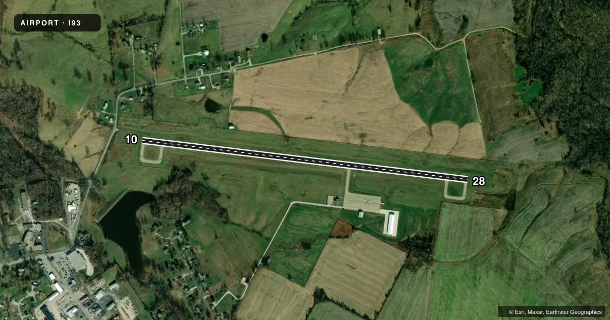
Airport sketch
Runways drawn to scale from FAA survey coordinates, rendered over satellite imagery. Not for navigation.
Approaches & charts
Services on the field
Fuel grades, oxygen, maintenance, ramp storage and lighting — as declared to the FAA by the airport operator.
Fuel & services
- Fuel
- 100LL
- Oxygen (bottled)
- Not available
- Oxygen (bulk)
- Not available
- Airframe repair
- Not available
- Power plant repair
- Not available
Ramp & ground
- Transient storage
- Tie-down
- Hangar
- Landing fee
- No fee published
- Customs
- Not available
- Lighting schedule
- SEE RMK
- Beacon schedule
- SS-SR
- Beacon
- White / Green (civil land)(WG)
- Wind indicator
- Lighted
- Segmented circle
- No
Fuel & FBOs
Cheapest 100LL and Jet A on the field and nearby. Always confirm with the FBO before taxi.
Airport notes
Surface conditions, obstructions, local procedures, lighting outages and other notes published with each FAA cycle.
General notes
- FUEL AVBL 24 HRS W/CREDIT CARD
- FOR CD CTC LOUISVILLE APCH AT 502-375-7499
Lighting notes
- ACTVT REIL RYS 10 & 28; PAPI RYS 10 & 28; MIRL RY 10/28 - 122.9.
Other notes
- VFR ONLY.
- MANAGERAIR BOARD CHAIR - MILLER MONARCH.
VFR map & nearby airports
VFR sectional. Tap any ICAO chip to open that airport.
Key facts · I93
Answer card- ICAO
- I93
- Name
- BRECKINRIDGE COUNTY
- Location
- HARDINSBURG, KENTUCKY
- Elevation
- 732.1 ft MSL
- Traffic pattern altitude
- 1,732.1 ft MSL (1,000 AGL)
- Control tower
- Non-towered (use CTAF)
- Total runways
- 1
- Longest runway
- 10/28 · 4,000 ft
- Published ILS approaches
- 0
- Published frequencies
- 3
- Magnetic variation
- 4°
- Current flight rules
- VFR
- Current wind
- 000° at 0 kt
- Favored runway now
- –
Breckinridge County Airport sits near Hardinsburg, Kentucky. Field elevation is 732.1 ft MSL. The airport has one runway. Runway 10/28 is 4,000 ft of concrete, so it is the runway to plan around here.
There is no control tower. VFR only operations are published, so build your arrival around self-announce traffic on CTAF 122.9. No ILS approaches are published. Pattern altitude is not published. Use the standard 1,000 ft AGL pattern for light piston work unless the current Chart Supplement says otherwise. The field is in the Louisville approach area, so get your clearance delivery and IFR coordination through Louisville Approach if you need it.
The on-field FBO is Breckinridge County Airport. It carries 100LL. Fuel is available 24 hours with credit card. Runway end identifier lights are published on both ends. PAPI is available on runways 10 and 28. Medium intensity runway lights are on runway 10/28 and are controlled on 122.9. That helps for night arrivals. You still need to stay within the published VFR-only limits. For a first-time arrival, the main things are the single runway layout, the non-towered traffic flow and the need to verify current airport notes before you go.