METAR & TAF I42
I42 does not publish a METAR.
Showing the nearest reporting station: KFRH (FRENCH LICK MUNI) · 9.4 NM away. Conditions at I42 may differ.
METAR · KFRH
Observed 04:15Z
KFRH 270415Z AUTO 00000KT 10SM SCT016 BKN026 OVC080 22/22 A2995 RMK AO1
- Wind
- 000° @ 0 kt
- Visibility
- 10 SM
- Temp / Dew
- 22°C / 22°C
- Altimeter
- 29.95 inHg
- Clouds
- OVC
- Density alt
- 1,815 ft
- Ceiling
- 2,600 ft AGL
- Rules
- MVFR
Airport info & contacts
Manager on record, flight service, ARTCC, attendance schedule and pattern altitude — published by the FAA and refreshed every 28 days.
Location
- From city
- 2 NM N
- VFR sectional
- ST LOUIS
- Pattern altitude
- 1,600 ft AGL · 2,416 ft MSL
- ARTCC
- ZID · INDIANAPOLIS
- NOTAM facility
- HUF (NOTAM-D)
Airport manager
- Name
- VANCE ALLDREN
- Phone
- 812-723-9923
- Address
- 182 WEST APPLEGATE, PAOLI IN 47454
Flight service · Hours
- FSS HUF
- TERRE HAUTE1-800-WX-BRIEF
- Attendance
- MON-SUN · 0800-1700
Frequencies
Tap any row to copy the frequency to your clipboard.
Runways & pattern
Full pagePattern entry · RWY 02
LEFT TRAFFICRunway end performance
| End | TORA | TODA | ASDA | LDA | VGSI | Approach lights | Obstruction |
|---|---|---|---|---|---|---|---|
| 02 | — | — | — | — | PAPI 2-box right(4°) | — | — |
| 20 | — | — | — | — | PAPI 2-box left(4°) | — | 25', trees, 400' from thr, 140' R of cntrln, slope 8 |
Declared distances in feet. TORA = takeoff run available, TODA = takeoff distance, ASDA = accelerate-stop, LDA = landing distance.
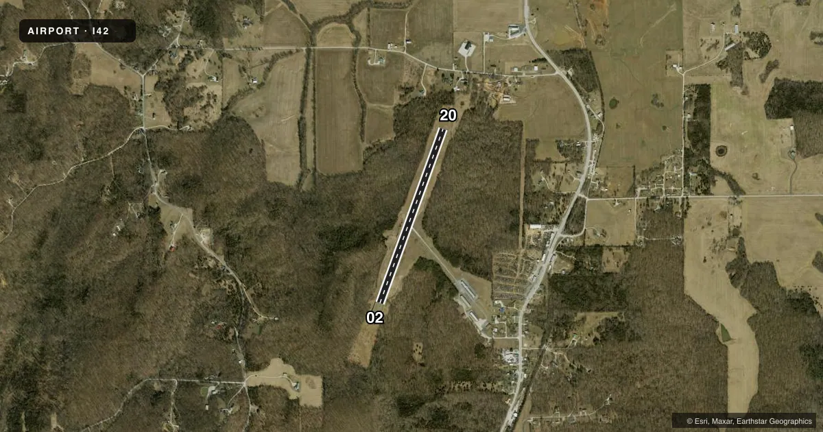
Airport sketch
Runways drawn to scale from FAA survey coordinates, rendered over satellite imagery. Not for navigation.
Approaches & charts
Services on the field
Fuel grades, oxygen, maintenance, ramp storage and lighting — as declared to the FAA by the airport operator.
Fuel & services
- Fuel
- 100LL
- Oxygen (bottled)
- Not available
- Oxygen (bulk)
- Not available
- Airframe repair
- Not available
- Power plant repair
- Not available
Ramp & ground
- Transient storage
- Tie-down
- Hangar
- Landing fee
- No fee published
- Customs
- Not available
- Lighting schedule
- SEE RMK
- Beacon schedule
- SS-SR
- Beacon
- White / Green (civil land)(WG)
- Wind indicator
- Lighted
- Segmented circle
- No
Fuel & FBOs
Cheapest 100LL and Jet A on the field and nearby. Always confirm with the FBO before taxi.
Airport notes
Surface conditions, obstructions, local procedures, lighting outages and other notes published with each FAA cycle.
General notes
- SNOW REMOVAL WINTER MONTHS.
- TERRIAN DROPS 8 FT 55 FT WEST OF APCH END OF RY 20 & A 10 FT TERRIAN DROP 55 FT EAST OF RY CNTRLN AT CENTER OF RY.
- FOR CD CTC LOUISVILLE APCH AT 502-375-7499
Lighting notes
- ACTVT MIRL RY 02/20 - CTAF.
Other notes
- HELI DTRMN: CONDL, ALL OPNS IN AREA TO/FM 80 DEG & 270-360 DEG, AREA MKD, WIND INDCR MAINTD.
- 1FOR AFTER HRS SERVICE CALL 812-865-6961
VFR map & nearby airports
VFR sectional. Tap any ICAO chip to open that airport.
Key facts · I42
Answer card- ICAO
- I42
- Name
- PAOLI MUNI
- Location
- PAOLI, INDIANA
- Elevation
- 816.4 ft MSL
- Traffic pattern altitude
- 2,416.4 ft MSL (1,600 AGL)
- Control tower
- Non-towered (use CTAF)
- Total runways
- 1
- Longest runway
- 02/20 · 3,302 ft
- Published ILS approaches
- 0
- Published frequencies
- 4
- Magnetic variation
- 1°
- Current flight rules
- MVFR
- Current wind
- 000° at 0 kt
- Favored runway now
- –
Paoli Muni sits in Paoli, Indiana. Field elevation is 816.4 ft MSL. The airport has one runway, 02/20, which is 3,302 ft long and asphalt. There is no control tower. Pattern altitude is 1,600 ft AGL, which is 2,416.4 ft MSL.
No ILS approaches are published here. CTAF and UNICOM are both 122.8. Louisville Approach is listed on 123.675 and 327.0 for approach and departure. If you need clearance delivery, the published contact is Louisville Approach at 502-375-7499. The runway lights on 02/20 are medium intensity and are activated by the CTAF.
Paoli Municipal Airport is on the field and carries 100LL. For after-hours service, the published number is 812-865-6961. Winter snow removal is noted in the Chart Supplement. Terrain near the runway deserves attention. The published remarks note a terrain drop west of the approach end of runway 20 and another drop east of the runway centerline near mid-field. That makes a careful look at the current chart and the airport remarks smart before arrival. Helicopter operations are also conditional in the area, so verify the current guidance before you go.