METAR & TAF 07I
07I does not publish a METAR.
Showing the nearest reporting station: KBMG (MONROE COUNTY) · 9.4 NM away. Conditions at 07I may differ.
METAR · KBMG
Observed 18:00Z
KBMG 251800Z 15005KT 10SM BKN010 OVC015 21/18 A3006 RMK AO2 CIG 009V013 T02110183 $
- Wind
- 150° @ 5 kt
- Visibility
- 10 SM
- Temp / Dew
- 21°C / 18°C
- Altimeter
- 30.06 inHg
- Clouds
- OVC
- Density alt
- 1,214 ft
- Ceiling
- 1,000 ft AGL
- Rules
- MVFR
Airport info & contacts
Manager on record, flight service, ARTCC, attendance schedule and pattern altitude — published by the FAA and refreshed every 28 days.
Location
- From city
- 7 NM SE
- VFR sectional
- ST LOUIS
- ARTCC
- ZID · INDIANAPOLIS
- NOTAM facility
- HUF (NOTAM-D)
Airport manager
- Name
- KENTON TURNER
- Phone
- (317) 232-0935
- Address
- 402 W. WASHINGTON ST., INDIANAPOLIS IN 46204
Flight service · Hours
- FSS HUF
- TERRE HAUTE1-800-WX-BRIEF
- Attendance
- Unattended
Frequencies
Tap any row to copy the frequency to your clipboard.
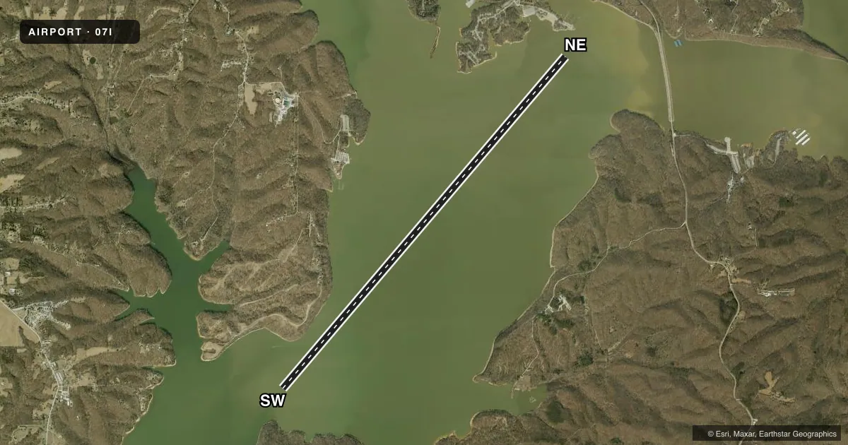
Runways & pattern
Full pagePattern entry · RWY NE
LEFT TRAFFICAirport sketch
Runways drawn to scale from FAA survey coordinates, rendered over satellite imagery. Not for navigation.
Approaches & charts
Services on the field
Fuel grades, oxygen, maintenance, ramp storage and lighting — as declared to the FAA by the airport operator.
Fuel & services
- Fuel
- Not available
Ramp & ground
- Transient storage
- Not published
- Segmented circle
- No
Fuel & FBOs
Cheapest 100LL and Jet A on the field and nearby. Always confirm with the FBO before taxi.
Airport notes
Surface conditions, obstructions, local procedures, lighting outages and other notes published with each FAA cycle.
General notes
- SEAPLANE OPS NA BTN SS-SR.
- LOW ALT HI-SPEED MIL TRNG ACT OVR OR NEAR RESERVOIR - CTC FLIGHT SERVICE FOR INFO.
- LAKE USE PERMIT RQR - 812-837-9546.
- FOR CD CTC HULMAN APCH AT 812-877-7581.
VFR map & nearby airports
VFR sectional. Tap any ICAO chip to open that airport.
Key facts · 07I
Answer card- ICAO
- 07I
- Name
- LAKE MONROE
- Location
- BLOOMINGTON, INDIANA
- Elevation
- 538 ft MSL
- Traffic pattern altitude
- 1,538 ft MSL (1,000 AGL)
- Control tower
- Non-towered (use CTAF)
- Total runways
- 1
- Longest runway
- SW/NE · 15,000 ft
- Published ILS approaches
- 0
- Published frequencies
- 1
- Magnetic variation
- 2°
- Current flight rules
- MVFR
- Current wind
- 150° at 5 kt
- Favored runway now
- RWY NE
Lake Monroe (07I) sits in Bloomington, Indiana. Field elevation is 538 ft MSL. The airport has one runway. It is a 15,000 ft water runway aligned 41°/221° magnetic. There is no control tower. CTAF is 122.9. No ILS approaches are published.
Pattern altitude is not published. Use the standard 1,000 ft AGL for light piston operations unless the current FAA Chart Supplement or the airport operator gives you something different. For this field, that works out to about 1,538 ft MSL based on the listed elevation. Seaplane operations are not authorized between sunset and sunrise. A lake use permit is required. Call 812-837-9546 before you plan a landing.
This field also has low altitude high-speed military training activity over or near the reservoir. That matters for arrival planning. Give yourself extra room to sort out traffic and stay sharp on the radio. For clearance delivery, contact Hulman Approach at 812-877-7581. There are no on-field FBOs listed in the facts, so verify current services with the airport operator or the FBO directly by phone before you go.