METAR & TAF 7I4
7I4 does not publish a METAR.
Showing the nearest reporting station: KBFR (VIRGIL I GRISSOM MUNI) · 10.9 NM away. Conditions at 7I4 may differ.
METAR · KBFR
Observed 05:35Z
KBFR 270535Z AUTO 00000KT 2 1/2SM BR FEW007 23/23 A2991 RMK AO2 LTG DSNT S VIS 1 1/4V4
- Wind
- 000° @ 0 kt
- Visibility
- 0.5 SM
- Temp / Dew
- 23°C / 23°C
- Altimeter
- 29.91 inHg
- Clouds
- FEW
- Density alt
- 1,785 ft
- Ceiling
- Unlimited
- Rules
- LIFR
Airport info & contacts
Manager on record, flight service, ARTCC, attendance schedule and pattern altitude — published by the FAA and refreshed every 28 days.
Location
- From city
- 1 NM E
- VFR sectional
- ST LOUIS
- ARTCC
- ZID · INDIANAPOLIS
- NOTAM facility
- HUF (NOTAM-D)
Airport manager
- Name
- AARON CARR
- Phone
- 812-583-1575
- Address
- 550 E SOUTH ST, ORLEANS IN 47452
Flight service · Hours
- FSS HUF
- TERRE HAUTE1-800-WX-BRIEF
- Attendance
- Unattended
Frequencies
Tap any row to copy the frequency to your clipboard.
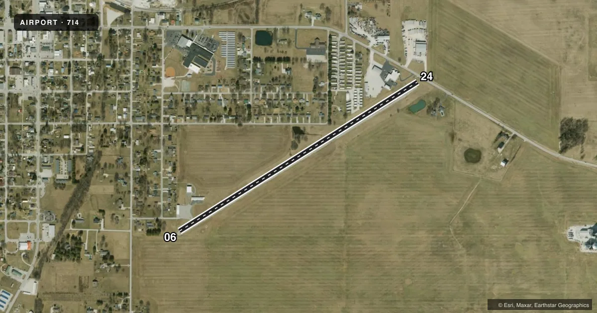
Runways & pattern
Full pagePattern entry · RWY 06
LEFT TRAFFICRunway end performance
| End | TORA | TODA | ASDA | LDA | VGSI | Approach lights | Obstruction |
|---|---|---|---|---|---|---|---|
| 06 | — | — | — | — | — | — | 68', tree, 930' from thr, 0' R of cntrln, slope 10 |
| 24 | — | — | — | — | — | — | 15', road, 201' from thr, 90' R of cntrln, slope 0 |
Declared distances in feet. TORA = takeoff run available, TODA = takeoff distance, ASDA = accelerate-stop, LDA = landing distance.
Airport sketch
Runways drawn to scale from FAA survey coordinates, rendered over satellite imagery. Not for navigation.
Approaches & charts
Services on the field
Fuel grades, oxygen, maintenance, ramp storage and lighting — as declared to the FAA by the airport operator.
Fuel & services
- Fuel
- Not available
- Airframe repair
- Not available
- Power plant repair
- Not available
- Other services
- INSTR
Ramp & ground
- Transient storage
- Tie-down
- Hangar
- Landing fee
- No fee published
- Lighting schedule
- SEE RMK
- Wind indicator
- Lighted
- Segmented circle
- No
Fuel & FBOs
Cheapest 100LL and Jet A on the field and nearby. Always confirm with the FBO before taxi.
Airport notes
Surface conditions, obstructions, local procedures, lighting outages and other notes published with each FAA cycle.
General notes
- SEASONAL AERIAL AG ACTIVITY. LIMITED RAMP SPACE DURING PEAK PERIODS.
- FOR CD CTC INDIANAPOLIS ARTCC AT 317-247-2411.
Lighting notes
- ACTVT LIRL - CTAF (5 SLOW CLICKS)
Runway surface & condition
- 06/24RY 06/24 NSTD LIRL; ONLY 2 THLD LGTS EACH SIDE OF RY. NO LGTS BTWN RY END & DSPLCD THLD BOTH ENDS.
Approach & departure obstructions
- 0610 FT CROPS 10 FT FM RWY END
- 2415 FT ROAD 130 FT FM RWY END
- 06NRS ARE SMALLER THAN STD.
- 06APCH 16:1 FM DTHR DUE TO 68 FT TREE 1130 FT FM RWY END
- 24APCH RATIO 24:1 FM DSPLCD THLD DUE TO 15 FT ROAD 130 FT FM RWY END
Other notes
- 06/24RWY SHOULDER SPALLING.
VFR map & nearby airports
VFR sectional. Tap any ICAO chip to open that airport.
Key facts · 7I4
Answer card- ICAO
- 7I4
- Name
- ORLEANS
- Location
- ORLEANS, INDIANA
- Elevation
- 655 ft MSL
- Traffic pattern altitude
- 1,655 ft MSL (1,000 AGL)
- Control tower
- Non-towered (use CTAF)
- Total runways
- 1
- Longest runway
- 06/24 · 3,456 ft
- Published ILS approaches
- 0
- Published frequencies
- 2
- Magnetic variation
- 1°
- Current flight rules
- LIFR
- Current wind
- 000° at 0 kt
- Favored runway now
- –
Orleans Airport sits in Orleans, Indiana. The field elevation is 655 ft MSL. It has one runway, 06/24, which is 3,456 ft long. There is no control tower. CTAF and UNICOM are both 122.8.
No ILS approaches are published here. The pattern altitude is not published, so use the standard 1,000 ft AGL for light piston operations unless the current Chart Supplement says otherwise. The runway has nonstandard low intensity lighting. You key the CTAF three slow clicks to turn it on. The lighting setup is limited. There are only two threshold lights on each side of the runway. There are no lights between the runway end and the displaced threshold at either end.
A first-time pilot should pay close attention on both ends. The 06 approach has nearby trees and crops. The 24 end has a road close to the runway end. The runway shoulder has spalling. Seasonal aerial agricultural activity also occurs. Ramp space is limited during peak periods. Clearance delivery is handled through Indianapolis ARTCC at 317-247-2411. No on-field FBOs are listed, so verify services with the airport operator or call the field on CTAF before you go.