METAR & TAF KSER
KSER does not publish a METAR.
Showing the nearest reporting station: KBAK (COLUMBUS MUNI) · 20.3 NM away. Conditions at KSER may differ.
METAR · KBAK
Observed 12:45Z
KBAK 271245Z 00000KT 1SM BR OVC001 23/22 A2992
- Wind
- 000° @ 0 kt
- Visibility
- 1 SM
- Temp / Dew
- 23°C / 22°C
- Altimeter
- 29.92 inHg
- Clouds
- OVC
- Density alt
- 1,683 ft
- Ceiling
- 100 ft AGL
- Rules
- LIFR
Airport info & contacts
Manager on record, flight service, ARTCC, attendance schedule and pattern altitude — published by the FAA and refreshed every 28 days.
Location
- From city
- 2 NM SW
- VFR sectional
- ST LOUIS
- ARTCC
- ZID · INDIANAPOLIS
- NOTAM facility
- HUF (NOTAM-D)
Airport manager
- Name
- COLIN SMITH
- Phone
- 812-522-2031
- Address
- 1025 A AVENUE, PO BOX 702, SEYMOUR IN 47274
Flight service · Hours
- FSS HUF
- TERRE HAUTE1-800-WX-BRIEF
- Attendance
- 0800-1630
Frequencies
Tap any row to copy the frequency to your clipboard.
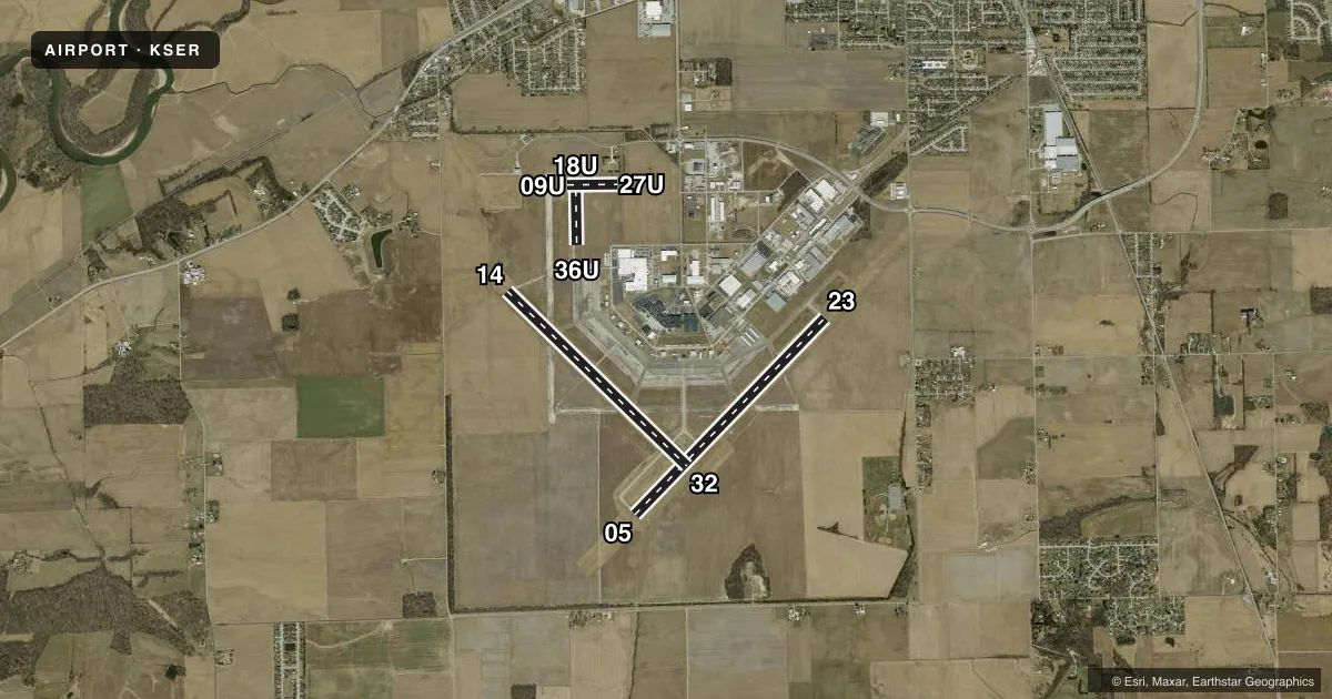
Runways & pattern
Full pagePattern entry · RWY 05
LEFT TRAFFIC| Runway | Heading (°M) | Length | Surface | Traffic |
|---|---|---|---|---|
| 05/23 | 42° / 222° | 6,001 ft | ASPH | Standard L |
| 14/32 | 132° / 312° | 5,502 ft | ASPH | Standard L |
| 18U/36U | 178° / 358° | 1,215 ft | TURF | 36U R |
| 09U/27U | 88° / 268° | 1,104 ft | TURF | Standard L |
Runway end performance
| End | TORA | TODA | ASDA | LDA | VGSI | Approach lights | Obstruction |
|---|---|---|---|---|---|---|---|
| 05 | — | — | — | — | PAPI 2-box left(3°) | ODALS | — |
| 23 | — | — | — | — | PAPI 2-box left(3°) | ODALS | — |
| 14 | — | — | — | — | PAPI 2-box left(3°) | — | 10', crops, 440' from thr, 0' R of cntrln, slope 24 |
| 32 | — | — | — | — | PAPI 2-box left(3°) | — | — |
Declared distances in feet. TORA = takeoff run available, TODA = takeoff distance, ASDA = accelerate-stop, LDA = landing distance.
Airport sketch
Runways drawn to scale from FAA survey coordinates, rendered over satellite imagery. Not for navigation.
Approaches & charts
Services on the field
Fuel grades, oxygen, maintenance, ramp storage and lighting — as declared to the FAA by the airport operator.
Fuel & services
- Fuel
- 100LLA1+
- Oxygen (bottled)
- Low pressure
- Airframe repair
- Minor
- Power plant repair
- Minor
- Other services
- AFRT,AGRI,AMB,CARGO,GLD,INSTR,RNTL,SURV
Ramp & ground
- Transient storage
- Tie-down
- Hangar
- Landing fee
- No fee published
- Customs
- Not available
- Lighting schedule
- SEE RMK
- Beacon schedule
- SS-SR
- Beacon
- White / Green (civil land)(WG)
- Wind indicator
- Lighted
- Segmented circle
- Yes
Fuel & FBOs
Cheapest 100LL and Jet A on the field and nearby. Always confirm with the FBO before taxi.
Airport notes
Surface conditions, obstructions, local procedures, lighting outages and other notes published with each FAA cycle.
General notes
- RDO CTL ACFT OPS ON & INVOF ARPT DLY FM APR - OCT.
- TWY LGTS FM INT 14/32 & 05/23 TO APRON ONLY.
- FOR CD CTC LOUISVILLE APCH AT 502-375-7499.
Lighting notes
- ACTVT ODALS RWY 05 & 23; REIL RWY 05, 14, 23 & 32; PAPI RWY 05, 14, 23 & 32 - CTAF. MIRL RWY 05/23 & 14/32 PRESET ON.
Fuel notes
- 100LLSELF SERVE AVBL 24 HR.
Approach & departure obstructions
- 09U30 FT PLINE MKD WITH BALLS 700 FT FM RWY END.
- 18U20 FT BLDG 550 FT FM RWY END.
VFR map & nearby airports
VFR sectional. Tap any ICAO chip to open that airport.
Key facts · KSER
Answer card- ICAO
- KSER
- Name
- FREEMAN MUNI
- Location
- SEYMOUR, INDIANA
- Elevation
- 582.7 ft MSL
- Traffic pattern altitude
- 1,582.7 ft MSL (1,000 AGL)
- Control tower
- Non-towered (use CTAF)
- Total runways
- 4
- Longest runway
- 05/23 · 6,001 ft
- Published ILS approaches
- 0
- Published frequencies
- 4
- Magnetic variation
- 2°
- Current flight rules
- LIFR
- Current wind
- 000° at 0 kt
- Favored runway now
- –
Freeman Muni sits in Seymour, Indiana at 582.7 ft MSL. It has four runways. The longest is runway 05/23 at 6,001 ft. Runway 14/32 is 5,502 ft. This is a non-towered field. For clearance delivery, contact Louisville Approach at 502-375-7499. Published frequencies include Louisville Approach on 132.075 and 327.0. CTAF and UNICOM are both on 122.8.
No ILS approaches are published here. Pattern altitude is not published, so use the standard 1,000 ft AGL for light piston operations unless the current Chart Supplement says otherwise. The field has one on-field FBO, Freeman Municipal Airport. It carries 100LL and Jet A. Self-serve 100LL is available 24 hours.
There are a few operational points worth having in mind before arrival. An omnidirectional approach lighting system is active for runways 05 and 23. REILs are installed on 05, 14, 23 and 32. PAPI is also installed on those same runways and is activated by CTAF. Taxiway lights run from the 14/32 and 05/23 intersection to the apron only. Watch the published obstacles near the turf ends. There is a 30-foot power line near runway 09U. There is a 20-foot building near runway 18U. Radio controlled aircraft operate on and near the airport daily from April through October.