METAR & TAF 3R8
3R8 does not publish a METAR.
Showing the nearest reporting station: KIMS (MADISON RGNL) · 16.5 NM away. Conditions at 3R8 may differ.
METAR · KIMS
Observed 13:35Z
KIMS 271335Z AUTO 00000KT 3/4SM BR OVC002 23/23 A2996 RMK AO2
- Wind
- 000° @ 0 kt
- Visibility
- 0.75 SM
- Temp / Dew
- 23°C / 23°C
- Altimeter
- 29.96 inHg
- Clouds
- OVC
- Density alt
- 1,654 ft
- Ceiling
- 200 ft AGL
- Rules
- LIFR
Airport info & contacts
Manager on record, flight service, ARTCC, attendance schedule and pattern altitude — published by the FAA and refreshed every 28 days.
Location
- From city
- 3 NM SW
- VFR sectional
- ST LOUIS
- ARTCC
- ZID · INDIANAPOLIS
- NOTAM facility
- HUF (NOTAM-D)
Airport manager
- Name
- SHAWN HONAKER
- Phone
- 502-377-4751
- Address
- 7001 AIRPORT DRIVE, SELLERSBURG IN 47172
Flight service · Hours
- FSS HUF
- TERRE HAUTE1-800-WX-BRIEF
- Attendance
- IREG
Frequencies
Tap any row to copy the frequency to your clipboard.
Runways & pattern
Full pagePattern entry · RWY 02
LEFT TRAFFICRunway end performance
| End | TORA | TODA | ASDA | LDA | VGSI | Approach lights | Obstruction |
|---|---|---|---|---|---|---|---|
| 02 | — | — | — | — | — | — | 60', trees, 745' from thr, 200' R of cntrln, slope 12 |
| 20 | — | — | — | — | — | — | 60', trees, 20' from thr, 125' R of cntrln, slope 0 |
Declared distances in feet. TORA = takeoff run available, TODA = takeoff distance, ASDA = accelerate-stop, LDA = landing distance.
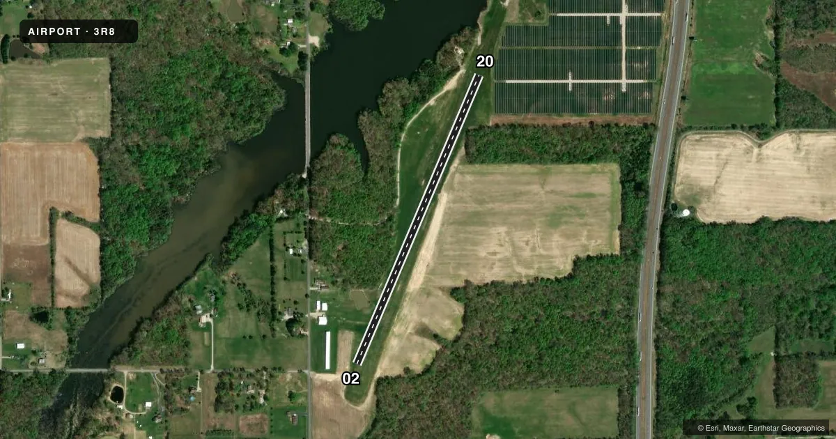
Airport sketch
Runways drawn to scale from FAA survey coordinates, rendered over satellite imagery. Not for navigation.
Approaches & charts
Services on the field
Fuel grades, oxygen, maintenance, ramp storage and lighting — as declared to the FAA by the airport operator.
Fuel & services
- Fuel
- Not available
- Other services
- INSTR,SALES
Ramp & ground
- Transient storage
- Tie-down
- Hangar
- Landing fee
- No fee published
- Wind indicator
- Yes
- Segmented circle
- Yes
Fuel & FBOs
Cheapest 100LL and Jet A on the field and nearby. Always confirm with the FBO before taxi.
Airport notes
Surface conditions, obstructions, local procedures, lighting outages and other notes published with each FAA cycle.
General notes
- ARPT CLSD DEC 1 - APR 1.
- TREES ALL QUADS.
- FOR CD CTC LOUISVILLE APCH AT 502-375-7499
Runway surface & condition
- 02/20THLD & DSPLCD THLD MKD BY ORANGE TFC CONES.
Approach & departure obstructions
- 02MKD BY ORANGE CONES.
- 20MKD BY ORANGE CONES.
VFR map & nearby airports
VFR sectional. Tap any ICAO chip to open that airport.
Key facts · 3R8
Answer card- ICAO
- 3R8
- Name
- HONAKER FLD
- Location
- SCOTTSBURG, INDIANA
- Elevation
- 600 ft MSL
- Traffic pattern altitude
- 1,600 ft MSL (1,000 AGL)
- Control tower
- Non-towered (use CTAF)
- Total runways
- 1
- Longest runway
- 02/20 · 2,750 ft
- Published ILS approaches
- 0
- Published frequencies
- 1
- Magnetic variation
- 2°
- Current flight rules
- LIFR
- Current wind
- 000° at 0 kt
- Favored runway now
- –
HONAKER FLD is in Scottsburg, Indiana. Field elevation is 600 ft MSL. The airport has one runway. The longest runway is 02/20 at 2,750 ft on turf. There is no control tower. CTAF is 122.9. No ILS approaches are published.
Pattern altitude is not published. Use the standard 1,000 ft AGL for light piston operations unless the current FAA Chart Supplement says otherwise. Trees are present in all quadrants around the airport. That matters on arrival and departure, especially with a turf strip and a short field. The airport is closed from December 1 to April 1, so verify status before planning a trip.
Runway ends and the threshold area are marked by orange cones. That is useful to know on a first visit because the markings are not the same as a paved field. For clearance delivery, contact Louisville Approach at 502-375-7499. There are no on-field FBOs listed, so call the airport operator directly before arrival if you need local support or fuel information.