METAR & TAF KLOU
Current METAR
Observed 12:53Z
KLOU 271253Z 00000KT 10SM CLR 24/22 A2992 RMK AO2 SLP126 T02440217
- Wind
- 000° @ 0 kt
- Visibility
- 10 SM
- Temp / Dew
- 24°C / 22°C
- Altimeter
- 29.92 inHg
- Clouds
- CLR
- Density alt
- 1,756 ft
- Ceiling
- Unlimited
- Rules
- VFR
Airport info & contacts
Manager on record, flight service, ARTCC, attendance schedule and pattern altitude — published by the FAA and refreshed every 28 days.
Location
- From city
- 5 NM SE
- VFR sectional
- ST LOUIS
- ARTCC
- ZID · INDIANAPOLIS
- NOTAM facility
- LOU (NOTAM-D)
Airport manager
- Name
- JORGIE DERMODY
- Phone
- 502-243-7305
- Address
- 3345 ROGER E SCHUPP STREET, LOUISVILLE KY 40205
Flight service · Hours
- FSS LOU
- LOUISVILLE1-800-WX-BRIEF
- Attendance
- 0700-2200
Frequencies
Tap any row to copy the frequency to your clipboard.
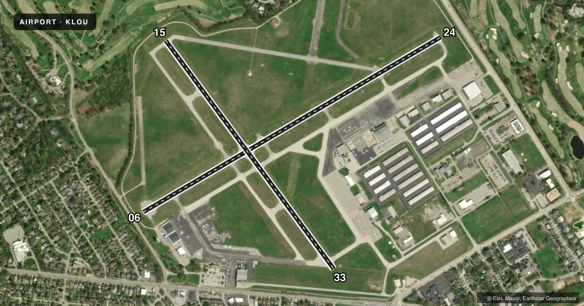
Runways & pattern
Full pagePattern entry · RWY 06
LEFT TRAFFIC| Runway | Heading (°M) | Length | Surface | Traffic |
|---|---|---|---|---|
| 06/24 | 56° / 236° | 4,358 ft | ASPH | Standard L |
| 15/33 | 140° / 320° | 3,580 ft | ASPH | Standard L |
Runway end performance
| End | TORA | TODA | ASDA | LDA | VGSI | Approach lights | Obstruction |
|---|---|---|---|---|---|---|---|
| 06 | 4,047' | 4,357' | 4,316' | 3,469' | PAPI 2-box left(3.5°) | — | 29', tree, 202' from thr, 232' R of cntrln, slope 0 |
| 24 | 3,509' | 4,357' | 4,165' | 3,856' | PAPI 2-box left(3°) | — | 13', tree, 378' from thr, 131' R of cntrln, slope 13 |
| 15 | 3,238' | 3,579' | 3,579' | 3,373' | PAPI 2-box left(3.5°) | — | 10', fence, 187' from thr, 28' R of cntrln, slope 0 |
| 33 | 3,373' | 3,579' | 3,466' | 3,125' | PAPI 2-box left(3.25°) | — | 22', road, 388' from thr, 235' R of cntrln, slope 8 |
Declared distances in feet. TORA = takeoff run available, TODA = takeoff distance, ASDA = accelerate-stop, LDA = landing distance.
Airport sketch
Runways drawn to scale from FAA survey coordinates, rendered over satellite imagery. Not for navigation.
Approaches & charts
Services on the field
Fuel grades, oxygen, maintenance, ramp storage and lighting — as declared to the FAA by the airport operator.
Fuel & services
- Fuel
- 100LLA
- Oxygen (bottled)
- HIGH/LOW
- Oxygen (bulk)
- HIGH/LOW
- Airframe repair
- Major
- Power plant repair
- Major
- Other services
- AMB,AVNCS,CHTR,INSTR,RNTL,SALES
Ramp & ground
- Transient storage
- Tie-down
- Hangar
- Landing fee
- No fee published
- Customs
- Not available
- Lighting schedule
- SEE RMK
- Beacon schedule
- SS-SR
- Beacon
- White / Green (civil land)(WG)
- Wind indicator
- Lighted
- Segmented circle
- No
Fuel & FBOs
Cheapest 100LL and Jet A on the field and nearby. Always confirm with the FBO before taxi.
Airport notes
Surface conditions, obstructions, local procedures, lighting outages and other notes published with each FAA cycle.
General notes
- STAGE 3 COMPLIANCE RQRD FOR TURBOJET; PPR OVR 30000 LB GWT - AMGR.
- TRNG OPS NA WHEN ATCT CLSD.
- OBSTNS & TREES IN ALL APCH SFCS.
- ADCUS FLT NOTIFICATION SVC AVBL.
- BIRDS ON & INVOF ARPT DURG DALGT HR.
- COMPASS ROSE LCTD AT ADMIN BLDG NOT FOR COMPASS CALIBRATION USE.
- 24 HR PPR FOR MIL ROTARY WING.
- FOR CD WHEN ATCT CLSD, CTC SDF ATCT 502-375-7499.
- NOISE ABATEMENT: NO PRACTICE APCH MON-SAT 2200-0700. SUN 2200-0900, OR WHEN TWR CLSD.
Lighting notes
- ACTVT MIRL RWY 06/24 & 15/33 - CTAF.
Approach & departure obstructions
- 068 FT FENCE 108 FT FM RWY END; 956 FT FM DTHR. ROAD 159 FT FM RWY END; 1007 FT FM DTHR.
- 15+8 FT FENCE 188 FT FM RWY END; 394 FT FM DTHR.
- 06CONTROLLING OBSTN EXCEEDS A 45 DEG SLP.
- 15CONTROLLING OBSTN EXCEEDS A 45 DEG SLP
- 24CLEAR 53:1 APCH TO DTHR.
- 33CLEAR 33:1 APCH TO DTHR.
- 156 FT PATH & GOLF CARTS.
Other notes
- EXISTED PRIOR TO 1959.
- MANAGERAMGR CELL 502-458-1475.
VFR map & nearby airports
VFR sectional. Tap any ICAO chip to open that airport.
Key facts · KLOU
Answer card- ICAO
- KLOU
- Name
- BOWMAN FLD
- Location
- LOUISVILLE, KENTUCKY
- Elevation
- 545.5 ft MSL
- Traffic pattern altitude
- 1,545.5 ft MSL (1,000 AGL)
- Control tower
- Towered · 0700-2200
- Total runways
- 2
- Longest runway
- 06/24 · 4,358 ft
- Published ILS approaches
- 0
- Published frequencies
- 9
- Magnetic variation
- 4°
- Current flight rules
- VFR
- Current wind
- 000° at 0 kt
- Favored runway now
- –
Bowman Fld is in Louisville, Kentucky. The field elevation is 545.5 ft MSL. It has two asphalt runways. The longest is runway 06/24 at 4,358 ft. The tower is open daily from 0700 to 2200. No ILS approaches are published here.
Pattern altitude is not published in the facts, so use the standard 1,000 ft AGL for light piston traffic unless the current Chart Supplement says otherwise. Louisville Executive Aviation is on the field. It carries 100LL and Jet A Prist. The airport also has ATIS, ground, clearance delivery, local control, UNICOM, CTAF and approach or departure service on the listed frequencies.
A few operational items matter here. Training operations are not authorized when the tower is closed. Noise abatement limits practice approaches late at night and early morning. Different Sunday hours apply. Runway 06 has an obstacle note near the threshold area. Runway 24 and runway 33 both have published clear approach slopes to the displaced threshold. The airport also requires stage 3 compliance for turbojet aircraft. If you are planning a heavier aircraft or military rotary wing flight, check the permission rules before you go. For the latest restrictions, verify the current Chart Supplement or call the airport manager directly.