METAR & TAF KIMS
Current METAR
Observed 05:55Z
KIMS 270555Z AUTO 11003KT 10SM SCT017 OVC023 23/23 A2995 RMK AO2
- Wind
- 110° @ 3 kt
- Visibility
- 10 SM
- Temp / Dew
- 23°C / 23°C
- Altimeter
- 29.95 inHg
- Clouds
- OVC
- Density alt
- 1,938 ft
- Ceiling
- 2,300 ft AGL
- Rules
- MVFR
Airport info & contacts
Manager on record, flight service, ARTCC, attendance schedule and pattern altitude — published by the FAA and refreshed every 28 days.
Location
- From city
- 4 NM W
- VFR sectional
- ST LOUIS
- ARTCC
- ZID · INDIANAPOLIS
- NOTAM facility
- HUF (NOTAM-D)
Airport manager
- Name
- BRENT SPRY
- Phone
- 812-273-1914
- Address
- 3919 W. IMS LANE, MADISON IN 47250
Flight service · Hours
- FSS HUF
- TERRE HAUTE1-800-WX-BRIEF
- Attendance
- MAR-OCT · 0800-1800
- NOV-FEB · 0800-1700
Frequencies
Tap any row to copy the frequency to your clipboard.
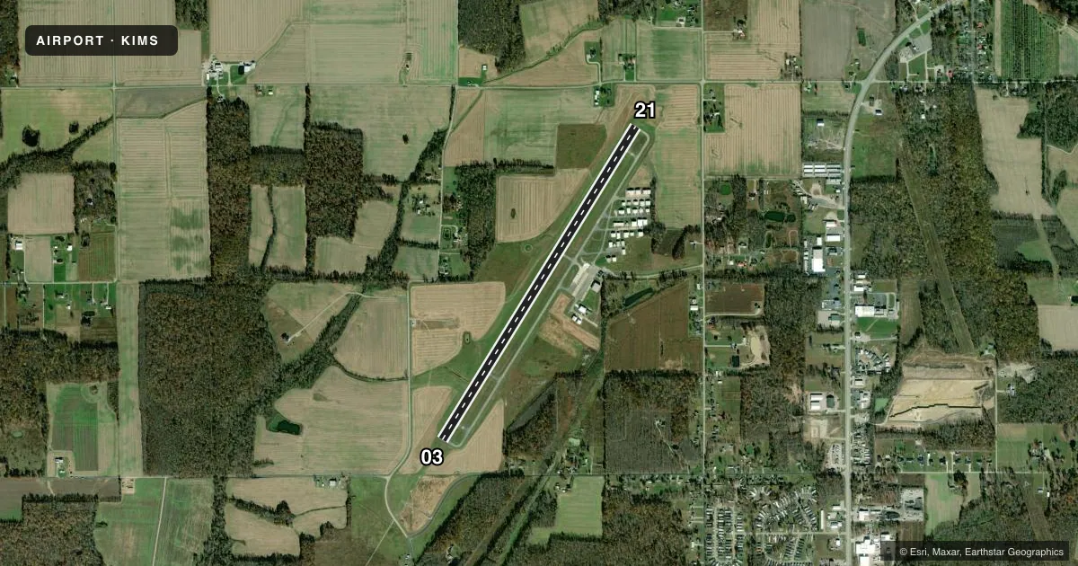
Runways & pattern
Full pagePattern entry · RWY 03
LEFT TRAFFICRunway end performance
| End | TORA | TODA | ASDA | LDA | VGSI | Approach lights | Obstruction |
|---|---|---|---|---|---|---|---|
| 03 | — | — | — | — | PAPI 4-box left(3.5°) | MALSF | 80', trees, 1850' from thr, 435' R of cntrln, slope 20 |
| 21 | — | — | — | — | PAPI 2-box left(3°) | — | 10', crops, 201' from thr, 0' R of cntrln, slope 20 |
Declared distances in feet. TORA = takeoff run available, TODA = takeoff distance, ASDA = accelerate-stop, LDA = landing distance.
Airport sketch
Runways drawn to scale from FAA survey coordinates, rendered over satellite imagery. Not for navigation.
Approaches & charts
Services on the field
Fuel grades, oxygen, maintenance, ramp storage and lighting — as declared to the FAA by the airport operator.
Fuel & services
- Fuel
- 100LLA
- Airframe repair
- Major
- Power plant repair
- Major
- Other services
- AGRI,AMB,INSTR,RNTL
Ramp & ground
- Transient storage
- Tie-down
- Hangar
- Landing fee
- No fee published
- Customs
- Not available
- Lighting schedule
- SEE RMK
- Beacon schedule
- SS-SR
- Beacon
- White / Green (civil land)(WG)
- Wind indicator
- Lighted
- Segmented circle
- No
Fuel & FBOs
Cheapest 100LL and Jet A on the field and nearby. Always confirm with the FBO before taxi.
Airport notes
Surface conditions, obstructions, local procedures, lighting outages and other notes published with each FAA cycle.
General notes
- FOR CD CTC LOUISVILLE APCH AT 502-375-7499
Lighting notes
- ACTVT MALSF RWY 03; REIL RWY 21; PAPI RWY 03 & 21; HIRL RWY 03/21 - CTAF.
Fuel notes
- 100LLSELF SERVE AVBL.
Other notes
- THIS AIRPORT HAS BEEN SURVEYED BY THE NATIONAL GEODETIC SURVEY.
- 1UNATNDD THANKSGIVING, CHRISTMAS & NEW YEARS.
VFR map & nearby airports
VFR sectional. Tap any ICAO chip to open that airport.
Key facts · KIMS
Answer card- ICAO
- KIMS
- Name
- MADISON RGNL
- Location
- MADISON, INDIANA
- Elevation
- 819.1 ft MSL
- Traffic pattern altitude
- 1,819.1 ft MSL (1,000 AGL)
- Control tower
- Non-towered (use CTAF)
- Total runways
- 1
- Longest runway
- 03/21 · 5,000 ft
- Published ILS approaches
- 0
- Published frequencies
- 4
- Magnetic variation
- 3°
- Current flight rules
- MVFR
- Current wind
- 110° at 3 kt
- Favored runway now
- RWY 03
Madison Regional Airport sits in Madison, Indiana. Field elevation is 819.1 ft MSL. The airport has one runway. Runway 03/21 is 5,000 ft long with asphalt pavement. There is no control tower, so use CTAF 123.0 for airport traffic. Pattern altitude is not published. Use the standard 1,000 ft AGL pattern for light piston aircraft unless the current Chart Supplement says otherwise.
No ILS approaches are published here. Louisville Approach handles approach and departure services on 132.075 and 327.0. For clearance delivery, contact Louisville Approach at 502-375-7499. The field has MALSF lighting on runway 03. Runway 21 has runway end identifier lights. PAPI and high intensity runway lights are published on both runway ends. The airport is unattended on Thanksgiving, Christmas and New Years.
Madison Regional Airport has one on-field FBO. Madison Regional Airport carries AVGAS 100LL and Jet A Prist. Self-serve 100LL fuel is available. First-time visitors should plan for an uncontrolled field with published lighting on both ends of the runway. The airport has been surveyed by the National Geodetic Survey. Check the current FAA Chart Supplement for any updates before departure.