METAR & TAF KOVO
KOVO does not publish a METAR.
Showing the nearest reporting station: KIMS (MADISON RGNL) · 18.4 NM away. Conditions at KOVO may differ.
METAR · KIMS
Observed 13:15Z
KIMS 271315Z AUTO 00000KT 2 1/2SM BR OVC002 23/23 A2995 RMK AO2
- Wind
- 000° @ 0 kt
- Visibility
- 0.5 SM
- Temp / Dew
- 23°C / 23°C
- Altimeter
- 29.95 inHg
- Clouds
- OVC
- Density alt
- 1,862 ft
- Ceiling
- 200 ft AGL
- Rules
- LIFR
Airport info & contacts
Manager on record, flight service, ARTCC, attendance schedule and pattern altitude — published by the FAA and refreshed every 28 days.
Location
- From city
- 2 NM NE
- VFR sectional
- ST LOUIS
- ARTCC
- ZID · INDIANAPOLIS
- NOTAM facility
- HUF (NOTAM-D)
Airport manager
- Name
- RYAN A. CURRY
- Phone
- 812-346-5223
- Address
- 645 E CO RD 450N, NORTH VERNON IN 47265
Flight service · Hours
- FSS HUF
- TERRE HAUTE1-800-WX-BRIEF
- Attendance
- MON-SAT · 0800-1700
- SUN · 1200-1700
Frequencies
Tap any row to copy the frequency to your clipboard.
Runways & pattern
Full pagePattern entry · RWY 05
LEFT TRAFFIC| Runway | Heading (°M) | Length | Surface | Traffic |
|---|---|---|---|---|
| 05/23 | 46° / 226° | 5,002 ft | ASPH | Standard L |
| 15/33 | 151° / 331° | 2,730 ft | ASPH | Standard L |
Runway end performance
| End | TORA | TODA | ASDA | LDA | VGSI | Approach lights | Obstruction |
|---|---|---|---|---|---|---|---|
| 05 | — | — | — | — | PAPI 2-box left(3°) | — | road, slope 34 |
| 23 | — | — | — | — | PAPI 2-box left(3°) | — | road, slope 34 |
| 15 | — | — | — | — | — | — | 14', road, 375' from thr, 140' R of cntrln, slope 12 |
| 33 | — | — | — | — | PAPI 2-box left(3.5°) | — | 55', trees, 1120' from thr, 205' R of cntrln, slope 16 |
Declared distances in feet. TORA = takeoff run available, TODA = takeoff distance, ASDA = accelerate-stop, LDA = landing distance.
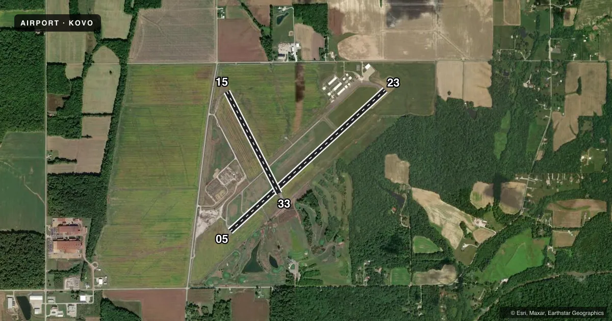
Airport sketch
Runways drawn to scale from FAA survey coordinates, rendered over satellite imagery. Not for navigation.
Approaches & charts
Services on the field
Fuel grades, oxygen, maintenance, ramp storage and lighting — as declared to the FAA by the airport operator.
Fuel & services
- Fuel
- 100LLA
- Oxygen (bottled)
- Not available
- Oxygen (bulk)
- Not available
- Airframe repair
- Major
- Power plant repair
- Major
- Other services
- INSTR,RNTL
Ramp & ground
- Transient storage
- Tie-down
- Hangar
- Landing fee
- No fee published
- Customs
- Not available
- Lighting schedule
- SEE RMK
- Beacon schedule
- SS-SR
- Beacon
- White / Green (civil land)(WG)
- Wind indicator
- Lighted
- Segmented circle
- No
Fuel & FBOs
Cheapest 100LL and Jet A on the field and nearby. Always confirm with the FBO before taxi.
Airport notes
Surface conditions, obstructions, local procedures, lighting outages and other notes published with each FAA cycle.
General notes
- 24 HR SELF SERVICE FUEL AVBL.
- FOR CD CTC INDIANAPOLIS APCH AT 317-227-5743.
Lighting notes
- ACTVT PAPI RWY 05 & 23: MIRL RWY 05/23 - CTAF.
Approach & departure obstructions
- 0510 FT CROPS 125 FT R OF RWY END CNTRLN.
- 1510 FT CROPS 60 FT L OF RWY END CNTRLN.
- 2310 FT CROPS 80 FT L OF RWY END CNTRLN.
- 3310 FT CROPS 60 FT L & R OF RWY END CNTRLN.
VFR map & nearby airports
VFR sectional. Tap any ICAO chip to open that airport.
Key facts · KOVO
Answer card- ICAO
- KOVO
- Name
- NORTH VERNON
- Location
- NORTH VERNON, INDIANA
- Elevation
- 757.2 ft MSL
- Traffic pattern altitude
- 1,757.2 ft MSL (1,000 AGL)
- Control tower
- Non-towered (use CTAF)
- Total runways
- 2
- Longest runway
- 05/23 · 5,002 ft
- Published ILS approaches
- 0
- Published frequencies
- 4
- Magnetic variation
- 2°
- Current flight rules
- LIFR
- Current wind
- 000° at 0 kt
- Favored runway now
- –
North Vernon Airport (KOVO) sits in North Vernon, Indiana. Field elevation is 757.2 ft MSL. The airport has two asphalt runways. The longest is runway 05/23 at 5,002 ft. Runway 15/33 is 2,730 ft.
There is no control tower. CTAF and UNICOM are both 122.7. Indianapolis Approach handles clearance delivery. No ILS approaches are published here, so plan for non-precision or visual work only and verify current procedures before you go. Pattern altitude is not published. Use 1,000 ft AGL for light piston operations unless the current Chart Supplement says otherwise.
North Vernon Municipal Airport is the on-field FBO. It carries 100LL and Jet A. 24-hour self-serve fuel is available. Runway 05 and runway 23 have PAPI and medium intensity lights that are activated by CTAF. That is useful after dark. Brief the CTAF lighting activation before arrival.
The field is in a low-elevation Indiana setting, so terrain is not the main issue. The bigger operational items are the short-field feel on runway 15/33, the published crop obstructions near the ends of all four runway directions and the lack of published ILS service. Check the current Chart Supplement for any additional local procedures before flying in.