METAR & TAF I34
I34 does not publish a METAR.
Showing the nearest reporting station: KHLB (BATESVILLE) · 12.5 NM away. Conditions at I34 may differ.
METAR · KHLB
Observed 19:35Z
KHLB 261935Z AUTO 00000KT 10SM OVC029 27/21 A2994 RMK A01
- Wind
- 000° @ 0 kt
- Visibility
- 10 SM
- Temp / Dew
- 27°C / 21°C
- Altimeter
- 29.94 inHg
- Clouds
- OVC
- Density alt
- 2,542 ft
- Ceiling
- 2,900 ft AGL
- Rules
- MVFR
Airport info & contacts
Manager on record, flight service, ARTCC, attendance schedule and pattern altitude — published by the FAA and refreshed every 28 days.
Location
- From city
- 2 NM SW
- VFR sectional
- ST LOUIS
- ARTCC
- ZID · INDIANAPOLIS
- NOTAM facility
- HUF (NOTAM-D)
Airport manager
- Name
- GARY BAILEY
- Phone
- 812-662-6224
- Address
- 3551 N. OLD US 421, GREENSBURG IN 47240
Flight service · Hours
- FSS HUF
- TERRE HAUTE1-800-WX-BRIEF
- Attendance
- MON-FRI · ON CALL
Frequencies
Tap any row to copy the frequency to your clipboard.
Runways & pattern
Full pagePattern entry · RWY 01
LEFT TRAFFICRunway end performance
| End | TORA | TODA | ASDA | LDA | VGSI | Approach lights | Obstruction |
|---|---|---|---|---|---|---|---|
| 01 | — | — | — | — | PAPI 2-box left(3°) | — | — |
| 19 | — | — | — | — | PAPI 2-box left(3°) | — | — |
Declared distances in feet. TORA = takeoff run available, TODA = takeoff distance, ASDA = accelerate-stop, LDA = landing distance.
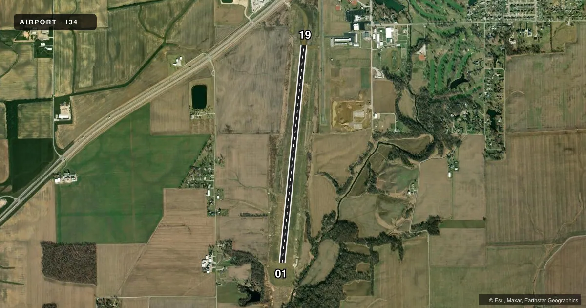
Airport sketch
Runways drawn to scale from FAA survey coordinates, rendered over satellite imagery. Not for navigation.
Approaches & charts
Services on the field
Fuel grades, oxygen, maintenance, ramp storage and lighting — as declared to the FAA by the airport operator.
Fuel & services
- Fuel
- 100LLA+
- Airframe repair
- Minor
- Power plant repair
- Minor
- Other services
- INSTR
Ramp & ground
- Transient storage
- Tie-down
- Landing fee
- No fee published
- Lighting schedule
- SEE RMK
- Beacon schedule
- SS-SR
- Beacon
- White / Green (civil land)(WG)
- Wind indicator
- Lighted
- Segmented circle
- No
Fuel & FBOs
Cheapest 100LL and Jet A on the field and nearby. Always confirm with the FBO before taxi.
Airport notes
Surface conditions, obstructions, local procedures, lighting outages and other notes published with each FAA cycle.
General notes
- FOR CD CTC INDIANAPOLIS APCH AT 317-227-5743.
Lighting notes
- ACTVT REIL RWY 01 & 19 AND MIRL RWY 01/19 - CTAF. PAPIS ON CONSLY.
Other notes
- EXISTED PRIOR TO 1959.
- 1ATTENDANT - AMGR
VFR map & nearby airports
VFR sectional. Tap any ICAO chip to open that airport.
Key facts · I34
Answer card- ICAO
- I34
- Name
- GREENSBURG MUNI
- Location
- GREENSBURG, INDIANA
- Elevation
- 908.9 ft MSL
- Traffic pattern altitude
- 1,908.9 ft MSL (1,000 AGL)
- Control tower
- Non-towered (use CTAF)
- Total runways
- 1
- Longest runway
- 01/19 · 5,406 ft
- Published ILS approaches
- 0
- Published frequencies
- 2
- Magnetic variation
- 4°
- Current flight rules
- MVFR
- Current wind
- 000° at 0 kt
- Favored runway now
- –
Greensburg Muni is in Greensburg, Indiana. The field elevation is 908.9 ft MSL. It has one runway, 01/19, which is 5,406 ft long and asphalt. The airport is not towered. CTAF is 122.9. Indianapolis Approach handles APCH/P DEP/P on 127.15. Clearance delivery goes through Indianapolis Approach at 317-227-5743.
No ILS approaches are published here. The pattern altitude is not published, so use the standard 1,000 ft AGL for light piston operations unless the current Chart Supplement says otherwise. That puts the pattern at about 1,909 ft MSL based on the field elevation. Verify the current published traffic pattern before you go.
Greensburg Municipal Airport is the on-field FBO. It carries 100LL and Jet A with Prist. The airport manager is the attendant. Runway end identifier lights are activated on 01 and 19 by using CTAF. Medium intensity runway lights are also on 01/19. PAPI is on continuously. For a first-time arrival, the main things to plan for are the non-towered traffic flow, the published lighting setup and coordination with Indianapolis Approach if you need clearance or IFR handling.