METAR & TAF KGEZ
Current METAR
Observed 11:40Z
KGEZ 271140Z AUTO 20003KT 1 1/2SM BR OVC003 21/21 A2993 RMK AO2 T02110206
- Wind
- 200° @ 3 kt
- Visibility
- 0.5 SM
- Temp / Dew
- 21°C / 21°C
- Altimeter
- 29.93 inHg
- Clouds
- OVC
- Density alt
- 1,703 ft
- Ceiling
- 300 ft AGL
- Rules
- LIFR
Airport info & contacts
Manager on record, flight service, ARTCC, attendance schedule and pattern altitude — published by the FAA and refreshed every 28 days.
Location
- From city
- 4 NM NW
- VFR sectional
- ST LOUIS
- Pattern altitude
- 800 ft AGL · 1,603 ft MSL
- ARTCC
- ZID · INDIANAPOLIS
- NOTAM facility
- GEZ (NOTAM-D)
Airport manager
- Name
- MARANDA SMITH
- Phone
- 317-392-1284
- Address
- 3529 N 100 WEST, SHELBYVILLE IN 46176
Flight service · Hours
- FSS HUF
- TERRE HAUTE1-800-WX-BRIEF
- Attendance
- 0800-1800
Frequencies
Tap any row to copy the frequency to your clipboard.
Runways & pattern
Full pagePattern entry · RWY 19
LEFT TRAFFIC| Runway | Heading (°M) | Length | Surface | Traffic |
|---|---|---|---|---|
| 01/19Favored | 1° / 181° | 5,000 ft | ASPH | Standard L |
| 09/27 | 88° / 268° | 2,671 ft | TURF | Standard L |
Runway end performance
| End | TORA | TODA | ASDA | LDA | VGSI | Approach lights | Obstruction |
|---|---|---|---|---|---|---|---|
| 01 | — | — | — | — | PAPI 2-box left(3°) | — | — |
| 19 | — | — | — | — | VASI 4-box left(3°) | — | — |
| 09 | — | — | — | — | — | — | 150', road, 15' from thr, 0' R of cntrln, slope 10 |
| 27 | — | — | — | — | — | — | 23', bldg, 325' from thr, 120' R of cntrln, slope 14 |
Declared distances in feet. TORA = takeoff run available, TODA = takeoff distance, ASDA = accelerate-stop, LDA = landing distance.
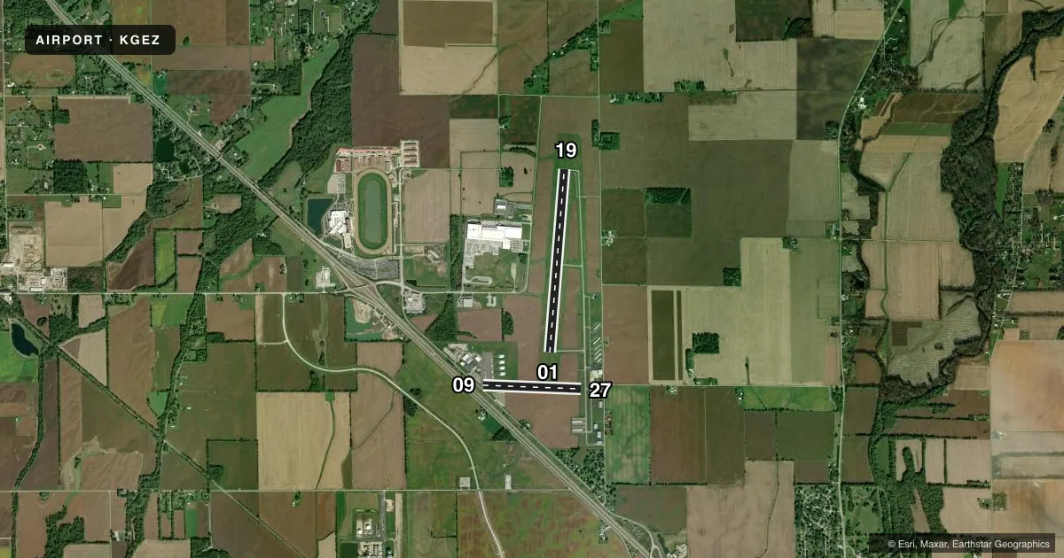
Airport sketch
Runways drawn to scale from FAA survey coordinates, rendered over satellite imagery. Not for navigation.
Approaches & charts
Services on the field
Fuel grades, oxygen, maintenance, ramp storage and lighting — as declared to the FAA by the airport operator.
Fuel & services
- Fuel
- 100LLAA+
- Oxygen (bottled)
- Not available
- Oxygen (bulk)
- Not available
- Airframe repair
- Major
- Power plant repair
- Major
- Other services
- INSTR,RNTL
Ramp & ground
- Transient storage
- Tie-down
- Hangar
- Landing fee
- No fee published
- Customs
- Not available
- Lighting schedule
- SEE RMK
- Beacon schedule
- SS-SR
- Beacon
- White / Green (civil land)(WG)
- Wind indicator
- Lighted
- Segmented circle
- No
Fuel & FBOs
Cheapest 100LL and Jet A on the field and nearby. Always confirm with the FBO before taxi.
Airport notes
Surface conditions, obstructions, local procedures, lighting outages and other notes published with each FAA cycle.
General notes
- HELICOPTER TFC ALL HRS. ANG HELI LCTD W OF ARPT.
- CTC ANG OPS 41.5/143.6/347.55.
- AP HEL LESS THAN 5000 LB VFR TFC PAT ALT 500 FT AGL.
Lighting notes
- ACTVT REIL RWY 01 & 19; PAPI RWY 01; VASI RWY 19; MIRL RWY 01/19 - CTAF.
Fuel notes
- 100LL100LL SELF SERVE AVBL
Approach & departure obstructions
- 09RWY 09/27 DSPLCD THLDS MKD WITH YELLOW CONES.
- 27RWY BEGINS W SIDE OF TWY A; GRASS LINE MARKS RWY EDGES.
- 09APCH SLOPE 40:1 AT DSPLCD THR.
- 27APCH RATIO 27:1 TO DSPLCD THLD.
Other notes
- THIS AIRPORT HAS BEEN SURVEYED BY THE NATIONAL GEODETIC SURVEY.
- 2ATNDD IREG ON HOLS
VFR map & nearby airports
VFR sectional. Tap any ICAO chip to open that airport.
Key facts · KGEZ
Answer card- ICAO
- KGEZ
- Name
- SHELBYVILLE MUNI
- Location
- SHELBYVILLE, INDIANA
- Elevation
- 802.5 ft MSL
- Traffic pattern altitude
- 1,602.5 ft MSL (800 AGL)
- Control tower
- Non-towered (use CTAF)
- Total runways
- 2
- Longest runway
- 01/19 · 5,000 ft
- Published ILS approaches
- 0
- Published frequencies
- 4
- Magnetic variation
- 4°
- Current flight rules
- LIFR
- Current wind
- 200° at 3 kt
- Favored runway now
- RWY 19
Shelbyville Muni is in Shelbyville, Indiana. The field elevation is 802.5 ft MSL. It has two runways. The longest is runway 01/19 at 5,000 ft of asphalt. Runway 09/27 is turf and measures 2,671 ft. There is no control tower. Use CTAF 122.8. The pattern altitude is 800 ft AGL, which is 1,602.5 ft MSL.
No ILS approaches are published here. If you need instrument work, check the current FAA Chart Supplement for the latest approach setup before you go. The airport has medium intensity runway lights on 01 and 19. REILs are on 01 and 19. PAPI is on runway 01. VASI is on runway 19. Runway 09/27 has displaced touchdown markings. Runway 27 begins on the west side of taxiway A. A grass line marks the runway edges.
Shelbyville Municipal Airport is on the field. It carries AVGAS 100LL, Jet A and Jet A Prist. 100LL self-serve fuel is available. Helicopter traffic is present at all hours. The Air National Guard helicopter is west of the airport. Expect that mix when you taxi and when you join the pattern. Attendance is irregular on Christmas, New Years, Easter and Thanksgiving. If you are planning a first stop here, verify current field status with the airport operator or the FBO directly by phone.