METAR & TAF KMQJ
Current METAR
Observed 13:35Z
KMQJ 271335Z AUTO 00000KT 1 1/2SM BR OVC002 23/23 A2992 RMK AO2 T02300230 $
- Wind
- 000° @ 0 kt
- Visibility
- 0.5 SM
- Temp / Dew
- 23°C / 23°C
- Altimeter
- 29.92 inHg
- Clouds
- OVC
- Density alt
- 2,029 ft
- Ceiling
- 200 ft AGL
- Rules
- LIFR
Airport info & contacts
Manager on record, flight service, ARTCC, attendance schedule and pattern altitude — published by the FAA and refreshed every 28 days.
Location
- From city
- 12 NM E
- VFR sectional
- ST LOUIS
- ARTCC
- ZID · INDIANAPOLIS
- NOTAM facility
- MQJ (NOTAM-D)
Airport manager
- Name
- KEITH BERLEN
- Phone
- 317-487-5022
- Address
- 7800 COL. H. WEIR COOK MEMORIAL DR., INDIANAPOLIS IN 46241
Flight service · Hours
- FSS HUF
- TERRE HAUTE1-800-WX-BRIEF
- Attendance
- 0600-2200
Frequencies
Tap any row to copy the frequency to your clipboard.
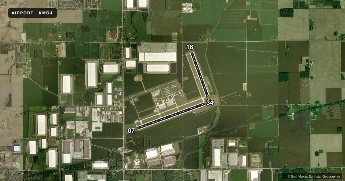
Runways & pattern
Full pagePattern entry · RWY 07
LEFT TRAFFIC| Runway | Heading (°M) | Length | Surface | Traffic |
|---|---|---|---|---|
| 07/25 | 68° / 248° | 6,005 ft | ASPH | Standard L |
| 16/34 | 158° / 338° | 3,902 ft | CONC | Standard L |
Runway end performance
| End | TORA | TODA | ASDA | LDA | VGSI | Approach lights | Obstruction |
|---|---|---|---|---|---|---|---|
| 07 | — | — | — | — | PAPI 4-box left(3°) | — | — |
| 25 | — | — | — | — | PAPI 4-box left(3°) | MALSR | — |
| 16 | — | — | — | — | PAPI 2-box left(3°) | — | — |
| 34 | — | — | — | — | PAPI 2-box left(3°) | — | — |
Declared distances in feet. TORA = takeoff run available, TODA = takeoff distance, ASDA = accelerate-stop, LDA = landing distance.
Airport sketch
Runways drawn to scale from FAA survey coordinates, rendered over satellite imagery. Not for navigation.
Approaches & charts
ILS · 1
Services on the field
Fuel grades, oxygen, maintenance, ramp storage and lighting — as declared to the FAA by the airport operator.
Fuel & services
- Fuel
- 100LLAA+
- Oxygen (bottled)
- HIGH/LOW
- Airframe repair
- Major
- Power plant repair
- Major
- Other services
- AFRT,CARGO,CHTR,INSTR,RNTL,SALES
Ramp & ground
- Transient storage
- Tie-down
- Hangar
- Customs
- Not available
- Lighting schedule
- SEE RMK
- Beacon schedule
- SS-SR
- Beacon
- White / Green (civil land)(WG)
- Wind indicator
- Lighted
- Segmented circle
- Yes
Fuel & FBOs
Cheapest 100LL and Jet A on the field and nearby. Always confirm with the FBO before taxi.
Airport notes
Surface conditions, obstructions, local procedures, lighting outages and other notes published with each FAA cycle.
General notes
- RWY 16/34 & TWY B NOT AVBL TO ACR WITH MORE THAN 30 PAX SEATS.
- FOR FUEL & SVC - 131.5
- FOR CD CTC INDIANAPOLIS APCH AT 317-227-5743.
Lighting notes
- DUSK-DAWN; ACTVT MALSR RWY 25; HIRL RWY 07/25 - CTAF.
Approach & departure obstructions
- 07CROPS 250 FT S OF RWY END.
- 16CROPS 155 FT FM & 175 FT W OF RWY END.
Other notes
- LCTD AT MID-FIELD WIND SOCK.
- 2AVBL AFT HR - 317-335-3371.
VFR map & nearby airports
VFR sectional. Tap any ICAO chip to open that airport.
Key facts · KMQJ
Answer card- ICAO
- KMQJ
- Name
- INDIANAPOLIS RGNL
- Location
- INDIANAPOLIS, INDIANA
- Elevation
- 862.3 ft MSL
- Traffic pattern altitude
- 1,862.3 ft MSL (1,000 AGL)
- Control tower
- Non-towered (use CTAF)
- Total runways
- 2
- Longest runway
- 07/25 · 6,005 ft
- Published ILS approaches
- 1
- Published frequencies
- 5
- Magnetic variation
- 2°
- Current flight rules
- LIFR
- Current wind
- 000° at 0 kt
- Favored runway now
- –
Indianapolis Rgnl sits in Indianapolis, Indiana. Field elevation is 862.3 ft MSL. The airport has 2 runways. The longest is runway 07/25 at 6,005 ft. There is no control tower, so expect non-towered procedures and monitor CTAF closely. The published pattern altitude is not listed. Use the standard 1,000 ft AGL pattern unless the current Chart Supplement says otherwise. That puts the light piston pattern at about 1,862 ft MSL.
Runway 25 has an ILS. Lighting is dusk to dawn. MALSR is activated on runway 25. High intensity runway lights are on runway 07/25 and are controlled by CTAF. Runway 16/34 is not available to aircraft with more than 30 passenger seats. Crops are noted near the ends of runway 16 and runway 07. Keep an eye on the departure path and threshold area.
Jet Access is on the field. It carries 100LL, Jet A and Jet A Prist. Fuel and service use frequency 131.5. After hours service is available by phone at (317) 335-3371. For clearance delivery, Indianapolis Approach can be reached at 317-227-5743. If you are planning a first stop here, verify current airspace and any local procedures with the current FAA Chart Supplement before arrival.