METAR & TAF KHFY
Current METAR
Observed 03:35Z
KHFY 260335Z AUTO 00000KT 7SM OVC014 21/19 A3001 RMK AO2 T02050185
- Wind
- 000° @ 0 kt
- Visibility
- 7 SM
- Temp / Dew
- 21°C / 19°C
- Altimeter
- 30.01 inHg
- Clouds
- OVC
- Density alt
- 1,628 ft
- Ceiling
- 1,400 ft AGL
- Rules
- MVFR
Airport info & contacts
Manager on record, flight service, ARTCC, attendance schedule and pattern altitude — published by the FAA and refreshed every 28 days.
Location
- From city
- 10 NM SE
- VFR sectional
- ST LOUIS
- Pattern altitude
- 800 ft AGL · 1,622 ft MSL
- ARTCC
- ZID · INDIANAPOLIS
- NOTAM facility
- HUF (NOTAM-D)
Airport manager
- Name
- RICK FERRILL
- Phone
- 317-881-0887
- Address
- 897 AIRPORT PKWY, GREENWOOD IN 46143
Flight service · Hours
- FSS HUF
- TERRE HAUTE1-800-WX-BRIEF
- Attendance
- MON-SAT · 0700-1900
- SUN · 0800-1700
Frequencies
Tap any row to copy the frequency to your clipboard.
Runways & pattern
Full pagePattern entry · RWY 01
LEFT TRAFFICRunway end performance
| End | TORA | TODA | ASDA | LDA | VGSI | Approach lights | Obstruction |
|---|---|---|---|---|---|---|---|
| 01 | — | — | — | — | PAPI 4-box left(3°) | — | 36', tree, 1125' from thr, 0' R of cntrln, slope 25 |
| 19 | — | — | — | — | PAPI 4-box left(3°) | ODALS | 13', road, 570' from thr, 280' R of cntrln, slope 28 |
Declared distances in feet. TORA = takeoff run available, TODA = takeoff distance, ASDA = accelerate-stop, LDA = landing distance.
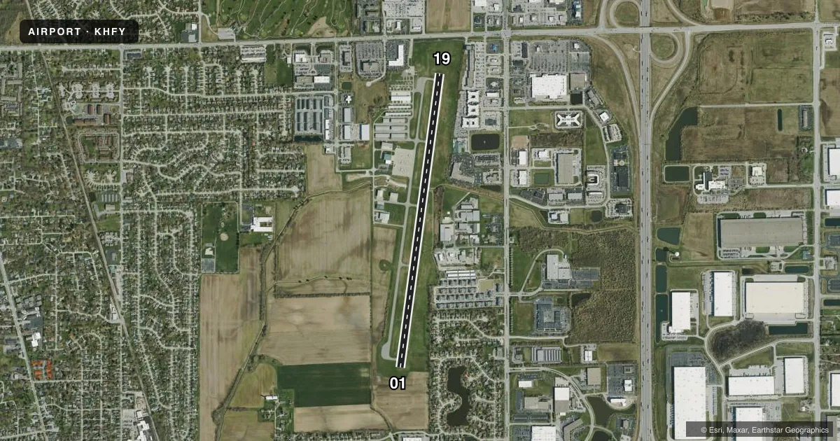
Airport sketch
Runways drawn to scale from FAA survey coordinates, rendered over satellite imagery. Not for navigation.
Approaches & charts
Services on the field
Fuel grades, oxygen, maintenance, ramp storage and lighting — as declared to the FAA by the airport operator.
Fuel & services
- Fuel
- 100LLAA+
- Oxygen (bottled)
- HIGH/LOW
- Oxygen (bulk)
- HIGH/LOW
- Airframe repair
- Major
- Power plant repair
- Major
- Other services
- CHTR,INSTR,RNTL,SALES
Ramp & ground
- Transient storage
- Tie-down
- Hangar
- Landing fee
- No fee published
- Customs
- Not available
- Lighting schedule
- SEE RMK
- Beacon schedule
- SS-SR
- Beacon
- White / Green (civil land)(WG)
- Wind indicator
- Lighted
- Segmented circle
- No
Fuel & FBOs
Cheapest 100LL and Jet A on the field and nearby. Always confirm with the FBO before taxi.
Airport notes
Surface conditions, obstructions, local procedures, lighting outages and other notes published with each FAA cycle.
General notes
- STUDENT TRNG INVOF ARPT.
- GCO AVBL ON FREQ 121.725 THRU INDIANAPOLIS CLNC AND FLIGHT SERVICES - TO ACTVT 4 SLOW CLICKS. IF UNAVBL CALL 317-227-5743.
- SELF SVC FUEL H24.
Lighting notes
- ACTVT REIL RWY 01; MIRL RWY 01/19 - CTAF.
Runway surface & condition
- 01/1910 FT DITCH 125 FT R & L OF CNTRLN.
Approach & departure obstructions
- 01APCH RATIO 34:1 AT DTHR.
- 19APCH RATIO 47:1 AT DTHR.
Other notes
- 1AFT HR - 317-760-4047.
VFR map & nearby airports
VFR sectional. Tap any ICAO chip to open that airport.
Key facts · KHFY
Answer card- ICAO
- KHFY
- Name
- INDY SOUTH GREENWOOD
- Location
- INDIANAPOLIS, INDIANA
- Elevation
- 822.1 ft MSL
- Traffic pattern altitude
- 1,622.1 ft MSL (800 AGL)
- Control tower
- Non-towered (use CTAF)
- Total runways
- 1
- Longest runway
- 01/19 · 5,102 ft
- Published ILS approaches
- 0
- Published frequencies
- 4
- Magnetic variation
- 2°
- Current flight rules
- MVFR
- Current wind
- 000° at 0 kt
- Favored runway now
- –
INDY SOUTH GREENWOOD sits in Indianapolis, Indiana. The field elevation is 822.1 ft MSL. It has one runway. Runway 01/19 is 5,102 ft long and paved with asphalt. There is no control tower, so expect CTAF traffic and standard non-towered procedures. Pattern altitude is 800 ft AGL. That is 1,622.1 ft MSL.
No ILS approaches are published here. Plan with the current chart and weather in mind. The on-field FBO is Indy South Greenwood Airport. It carries 100LL, Jet A and Jet A Prist. Self-serve fuel is available 24 hours a day. The published remarks also note student training in the area. Expect training traffic and be ready for close-in pattern work.
There are a few operational details worth brief attention. Runway end identifier lights are on runway 01. Medium intensity runway lights are on both ends and are controlled by CTAF. There is a 10-foot ditch 125 feet right and left of the runway centerline. The displaced thresholds also have published approach clearance slopes. If you are new to the airport, give yourself time to brief the pattern, lighting and traffic flow before arrival. Check the current FAA Chart Supplement for any updated notes before you go.