METAR & TAF KUMP
Current METAR
Observed 11:35Z
KUMP 271135Z AUTO 00000KT 1 3/4SM BR OVC003 22/22 A2992 RMK AO2 T02230223 $
- Wind
- 000° @ 0 kt
- Visibility
- 0.75 SM
- Temp / Dew
- 22°C / 22°C
- Altimeter
- 29.92 inHg
- Clouds
- OVC
- Density alt
- 1,846 ft
- Ceiling
- 300 ft AGL
- Rules
- LIFR
Airport info & contacts
Manager on record, flight service, ARTCC, attendance schedule and pattern altitude — published by the FAA and refreshed every 28 days.
Location
- From city
- 8 NM NE
- VFR sectional
- ST LOUIS
- ARTCC
- ZID · INDIANAPOLIS
- NOTAM facility
- HUF (NOTAM-D)
Airport manager
- Name
- KEITH BERLEN
- Phone
- (317) 487-7243
- Address
- 7800 COL H. WEIR COOK MEM. DRIVE, SUITE 100, INDIANAPOLIS IN 46241-4941
Flight service · Hours
- FSS HUF
- TERRE HAUTE1-800-WX-BRIEF
- Attendance
- 0800-1900
Frequencies
Tap any row to copy the frequency to your clipboard.
Runways & pattern
Full pagePattern entry · RWY 15
LEFT TRAFFICRunway end performance
| End | TORA | TODA | ASDA | LDA | VGSI | Approach lights | Obstruction |
|---|---|---|---|---|---|---|---|
| 15 | — | — | — | — | PAPI 4-box left(3°) | — | 11', road, 275' from thr, 260' R of cntrln, slope 6 |
| 33 | — | — | — | — | PAPI 4-box left(3.5°) | — | — |
Declared distances in feet. TORA = takeoff run available, TODA = takeoff distance, ASDA = accelerate-stop, LDA = landing distance.
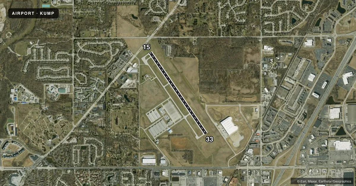
Airport sketch
Runways drawn to scale from FAA survey coordinates, rendered over satellite imagery. Not for navigation.
Approaches & charts
Services on the field
Fuel grades, oxygen, maintenance, ramp storage and lighting — as declared to the FAA by the airport operator.
Fuel & services
- Fuel
- 100LLA
- Oxygen (bottled)
- High pressure
- Oxygen (bulk)
- Not available
- Airframe repair
- Major
- Power plant repair
- Major
- Other services
- AMB,CHTR,INSTR,RNTL,SALES
Ramp & ground
- Transient storage
- Tie-down
- Hangar
- Landing fee
- No fee published
- Customs
- Not available
- Lighting schedule
- SEE RMK
- Beacon schedule
- SS-SR
- Beacon
- White / Green (civil land)(WG)
- Wind indicator
- Lighted
Fuel & FBOs
Cheapest 100LL and Jet A on the field and nearby. Always confirm with the FBO before taxi.
Airport notes
Surface conditions, obstructions, local procedures, lighting outages and other notes published with each FAA cycle.
General notes
- OUTSIDE PHONE AVBL.
- ACFT TAKEOFF/LANDING FM RY 15 DURING CALM WIND/CROSSWIND CONDITIONS; DURING ANY QUESTIONABLE PERIOD RY 15 SHALL BE PREFERRED RY - CALL AMGR 317-487-9594.
- FBO PHONE NUMBER - 317-849-0840
- 500 FT AGL MOORED HOT AIR BALLOON LCTD APRXLY 4.4 MILES NORTH-NORTHWEST OF ARPT. BALLOON WILL OPER DLY FROM 1300-2200Z++ AND IS INTERNALLY ILLUMINATED.
Lighting notes
- ACTVT REIL RWY 15 AND 33, MIRL RWY 15/33 - CTAF.
Approach & departure obstructions
- 15APCH SLOPE 21:1 AT DSPLCD THR; 37 FT TREES 800 FT FM DSPLCD THR 260 FT LEFT.
VFR map & nearby airports
VFR sectional. Tap any ICAO chip to open that airport.
Key facts · KUMP
Answer card- ICAO
- KUMP
- Name
- INDIANAPOLIS METRO
- Location
- INDIANAPOLIS, INDIANA
- Elevation
- 811.3 ft MSL
- Traffic pattern altitude
- 1,811.3 ft MSL (1,000 AGL)
- Control tower
- Non-towered (use CTAF)
- Total runways
- 1
- Longest runway
- 15/33 · 4,004 ft
- Published ILS approaches
- 0
- Published frequencies
- 5
- Magnetic variation
- 3°
- Current flight rules
- LIFR
- Current wind
- 000° at 0 kt
- Favored runway now
- –
Indianapolis Metro is in Indianapolis, Indiana. The field elevation is 811.3 ft MSL. It has one runway, 15/33, which is 4,004 ft long and asphalt. There is no control tower. No ILS approaches are published, so plan with current weather and the available non-precision options in mind.
The published pattern altitude is not listed. Use 1,000 ft AGL for light piston operations unless the current Chart Supplement says otherwise. Tom Wood Aviation is on the field. It carries 100LL and Jet A Prist. The published remarks also note an outside phone is available.
Runway 15 is the preferred runway during calm wind or any questionable period. That matters here because the Chart Supplement also calls out trees near the displaced threshold on 15. There is a 500 ft AGL moored hot air balloon about 4.4 miles north-northwest of the airport. It operates daily from 1300 to 2200 Zulu and is internally illuminated. Runway end identifier lights are on 15 and 33. Medium intensity runway lights on both ends are controlled by CTAF. Check the current Chart Supplement for any updated local procedures before you go.