METAR & TAF KEYE
Current METAR
Observed 09:53Z
KEYE 270953Z AUTO 00000KT 9SM CLR 22/21 A2990 RMK AO2 SLP116 T02170211
- Wind
- 000° @ 0 kt
- Visibility
- 9 SM
- Temp / Dew
- 22°C / 21°C
- Altimeter
- 29.90 inHg
- Clouds
- CLR
- Density alt
- 1,885 ft
- Ceiling
- Unlimited
- Rules
- VFR
Airport info & contacts
Manager on record, flight service, ARTCC, attendance schedule and pattern altitude — published by the FAA and refreshed every 28 days.
Location
- From city
- 7 NM W
- VFR sectional
- ST LOUIS
- ARTCC
- ZID · INDIANAPOLIS
- NOTAM facility
- EYE (NOTAM-D)
Airport manager
- Name
- KEITH BERLEN
- Phone
- (317) 487-5022
- Address
- 7800 COL. H. WEIR COOK MEMORIAL DR., SUITE 100, INDIANAPOLIS IN 46241
Flight service · Hours
- FSS HUF
- TERRE HAUTE1-800-WX-BRIEF
- Attendance
- 0700-DUSK
Frequencies
Tap any row to copy the frequency to your clipboard.
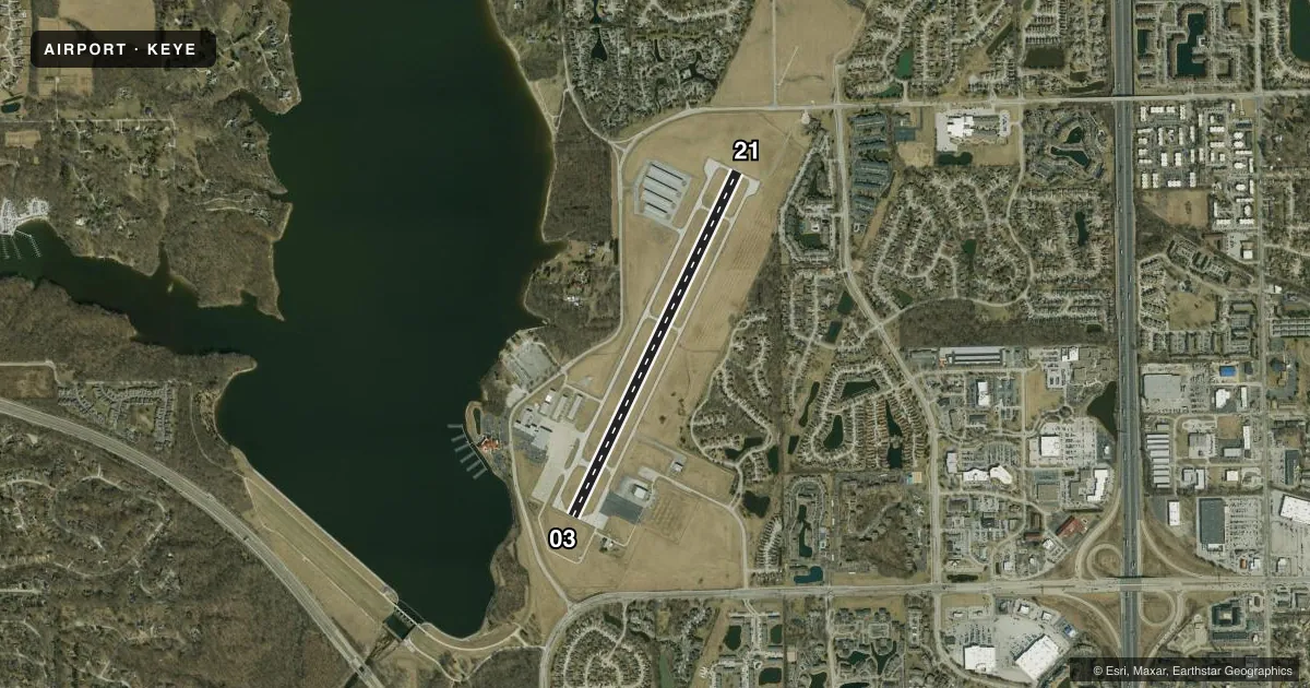
Runways & pattern
Full pagePattern entry · RWY 03
LEFT TRAFFICRunway end performance
| End | TORA | TODA | ASDA | LDA | VGSI | Approach lights | Obstruction |
|---|---|---|---|---|---|---|---|
| 03 | — | — | — | — | PAPI 2-box left(3°) | — | 42', trees, 830' from thr, 130' R of cntrln, slope 15 |
| 21 | — | — | — | — | PAPI 2-box left(3°) | MALS | 13', road, 608' from thr, 0' R of cntrln, slope 31 |
Declared distances in feet. TORA = takeoff run available, TODA = takeoff distance, ASDA = accelerate-stop, LDA = landing distance.
Airport sketch
Runways drawn to scale from FAA survey coordinates, rendered over satellite imagery. Not for navigation.
Approaches & charts
ILS · 1
Services on the field
Fuel grades, oxygen, maintenance, ramp storage and lighting — as declared to the FAA by the airport operator.
Fuel & services
- Fuel
- 100LLA
- Oxygen (bottled)
- HIGH/LOW
- Oxygen (bulk)
- High pressure
- Airframe repair
- Major
- Power plant repair
- Major
- Other services
- AFRT,AVNCS,CHTR,INSTR,RNTL,SALES,SURV
Ramp & ground
- Transient storage
- Tie-down
- Hangar
- Landing fee
- No fee published
- Customs
- Not available
- Lighting schedule
- SEE RMK
- Beacon schedule
- SS-SR
- Beacon
- White / Green (civil land)(WG)
- Wind indicator
- Lighted
- Segmented circle
- Yes
Fuel & FBOs
Cheapest 100LL and Jet A on the field and nearby. Always confirm with the FBO before taxi.
Airport notes
Surface conditions, obstructions, local procedures, lighting outages and other notes published with each FAA cycle.
General notes
- OUTSIDE PHONES AVBL.
- ACFT TKOF/LNDG FM RY 03 DURING CALM WIND/CROSSWIND CONDS; DURING ANY QUESTIONABLE PERIOD RY 03 SHALL BE PREFERRED RY - CALL AMGR 317-487-9594.
- ACFT DEPARTING RY 3 MUST MAINTAIN RY HEADING UNTIL 1500 FT MSL BFR TURNING ON CRS.
- FOR CD CTC INDIANAPOLIS APCH AT 317-227-5743.
Lighting notes
- MIRL RY 03/21 PRESET ON LOW INTST; TO INCR INTST & ACTVT MALS RY 21 & REIL RY 03 - CTAF.
Fuel notes
- 100LL100LL HAS 24 HR SELF SERVICE
Approach & departure obstructions
- 21CLOSEST INTCP POINT.
- 03RWY 03 APCH RATIO 20:1 TO THLD
VFR map & nearby airports
VFR sectional. Tap any ICAO chip to open that airport.
Key facts · KEYE
Answer card- ICAO
- KEYE
- Name
- EAGLE CREEK AIRPARK
- Location
- INDIANAPOLIS, INDIANA
- Elevation
- 822.9 ft MSL
- Traffic pattern altitude
- 1,822.9 ft MSL (1,000 AGL)
- Control tower
- Non-towered (use CTAF)
- Total runways
- 1
- Longest runway
- 03/21 · 4,200 ft
- Published ILS approaches
- 1
- Published frequencies
- 5
- Magnetic variation
- 5°
- Current flight rules
- VFR
- Current wind
- 000° at 0 kt
- Favored runway now
- –
Eagle Creek Airpark sits in Indianapolis, Indiana. Field elevation is 822.9 ft MSL. The airport has one runway, 03/21, which is 4,200 ft long and asphalt. There is no control tower. The field has one ILS approach, with service to runway 21. Pattern altitude is not published. Use the standard 1,000 ft AGL pattern for light piston aircraft unless the current Chart Supplement says otherwise.
Jet Access is on the field. It carries 100LL, Jet A and Jet A Prist. 100LL is available as 24-hour self-serve. For clearance delivery, contact Indianapolis Approach. The published remarks also say runway 03 is the preferred runway during calm wind or when wind conditions are questionable. Aircraft departing runway 03 must stay runway heading until 1,500 ft MSL before turning on course. The runway 03 approach has a 20:1 obstacle surface to the threshold, so give that end a careful look on arrival and departure.
This is a busy Indianapolis-area airport with controlled approach services nearby. Check the current FAA Chart Supplement before you go. Pay attention to runway lighting use on CTAF. The medium intensity lights and the runway 21 approach lighting are pilot-activated.