METAR & TAF KIND
Current METAR
Observed 13:03Z
KIND 271303Z 00000KT 5SM BR FEW002 SCT006 SCT120 24/23 A2991 RMK AO2 T02440228 $
- Wind
- 000° @ 0 kt
- Visibility
- 5 SM
- Temp / Dew
- 24°C / 23°C
- Altimeter
- 29.91 inHg
- Clouds
- SCT
- Density alt
- 2,080 ft
- Ceiling
- Unlimited
- Rules
- MVFR
Airport info & contacts
Manager on record, flight service, ARTCC, attendance schedule and pattern altitude — published by the FAA and refreshed every 28 days.
Location
- From city
- 7 NM SW
- VFR sectional
- ST LOUIS
- ARTCC
- ZID · INDIANAPOLIS
- NOTAM facility
- IND (NOTAM-D)
Airport manager
- Name
- MARIO RODRIGUEZ
- Phone
- 317-487-9594
- Address
- 7800 COL. H. WEIR COOK MEMORIAL DR., INDIANAPOLIS IN 46241
Flight service · Hours
- FSS HUF
- TERRE HAUTE1-800-WX-BRIEF
- Attendance
- ALL
Frequencies
Tap any row to copy the frequency to your clipboard.
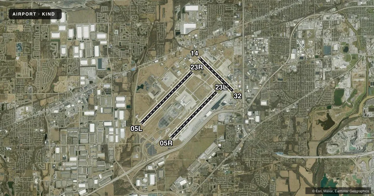
Runways & pattern
Full pagePattern entry · RWY 05L
LEFT TRAFFIC| Runway | Heading (°M) | Length | Surface | Traffic |
|---|---|---|---|---|
| 05L/23R | 40° / 220° | 11,200 ft | CONC | Standard L |
| 05R/23L | 40° / 220° | 10,000 ft | CONC | Standard L |
| 14/32 | 130° / 310° | 7,278 ft | ASPH | Standard L |
Runway end performance
| End | TORA | TODA | ASDA | LDA | VGSI | Approach lights | Obstruction |
|---|---|---|---|---|---|---|---|
| 05L | 11,200' | 11,200' | 11,200' | 11,200' | PAPI 4-box left(3°) | ALSF2 | — |
| 23R | 11,200' | 11,200' | 11,200' | 11,200' | PAPI 4-box left(3°) | MALSR | — |
| 05R | 10,000' | 10,000' | 10,000' | 10,000' | PAPI 4-box left(3°) | ALSF2 | — |
| 23L | 10,000' | 10,000' | 10,000' | 10,000' | PAPI 4-box left(3°) | MALSR | — |
| 14 | 7,278' | 7,278' | 7,278' | 7,278' | PAPI 4-box left(3°) | MALSR | 61', ant, 2370' from thr, 756' R of cntrln, slope 35 |
| 32 | 7,278' | 7,278' | 7,278' | 7,278' | PAPI 4-box right(3°) | MALSR | — |
Declared distances in feet. TORA = takeoff run available, TODA = takeoff distance, ASDA = accelerate-stop, LDA = landing distance.
Airport sketch
Runways drawn to scale from FAA survey coordinates, rendered over satellite imagery. Not for navigation.
Approaches & charts
ILS · 6
Services on the field
Fuel grades, oxygen, maintenance, ramp storage and lighting — as declared to the FAA by the airport operator.
Fuel & services
- Fuel
- 100LLAA1+
- Oxygen (bottled)
- High pressure
- Oxygen (bulk)
- High pressure
- Airframe repair
- Major
- Power plant repair
- Major
- Other services
- CARGO
Ramp & ground
- Transient storage
- Tie-down
- Customs
- Not available
- Beacon schedule
- SS-SR
- Beacon
- White / Green (civil land)(WG)
- Wind indicator
- Lighted
- Segmented circle
- No
Fuel & FBOs
Cheapest 100LL and Jet A on the field and nearby. Always confirm with the FBO before taxi.
Airport notes
Surface conditions, obstructions, local procedures, lighting outages and other notes published with each FAA cycle.
General notes
- PRIM STUDENT TGL NOT PMTD.
- LARGE FLOCKS OF BIRDS ON & INVOF ARPT.
- NOISE ABATEMENT PROCEDURES IN EFFECT CTC ARPT MGR.
- BE ALERT TO CLOSE PROXIMITY OF RWY 14/32 TO NORTHEAST RAMP.
- TWY H RUNS CONTIGUOUS AT NORTHEAST RAMP.
- TWY V IS NOT AVBL FOR ACR OPS.
Runway surface & condition
- 05L/23RPCR VALUE: 1360/R/D/W/U
- 05R/23LPCR VALUE: 1510/R/D/W/T
- 14/32PCR VALUE: 710/F/D/W/T
Approach & departure obstructions
- 14PAPI UNUSBL BYD 8 DEGS RIGHT OF CNTRLN.
- 23LPAPI UNUSBL BYD 7 DEGS LEFT OF CNTRLN.
VFR map & nearby airports
VFR sectional. Tap any ICAO chip to open that airport.
Key facts · KIND
Answer card- ICAO
- KIND
- Name
- INDIANAPOLIS INTL
- Location
- INDIANAPOLIS, INDIANA
- Elevation
- 796.2 ft MSL
- Traffic pattern altitude
- 1,796.2 ft MSL (1,000 AGL)
- Control tower
- Towered · 24
- Total runways
- 3
- Longest runway
- 05L/23R · 11,200 ft
- Published ILS approaches
- 6
- Published frequencies
- 19
- Magnetic variation
- 5°
- Current flight rules
- MVFR
- Current wind
- 000° at 0 kt
- Favored runway now
- –
Indianapolis Intl is in Indianapolis, Indiana. The field elevation is 796.2 ft MSL. It has 3 runways. The longest is runway 05L/23R at 11,200 ft. The airport is towered 24 hours a day. Six ILS approaches are published for runway ends 05L, 05R, 14, 23L, 23R and 32. Pattern altitude is not published in the facts. Use the current Chart Supplement for the published traffic pattern or any special procedures before you go.
Two on-field FBOs are listed. Signature Aviation carries 100LL and Jet A. Million Air carries 100LL, Jet A and Jet A Prist. Noise abatement procedures are in effect. Contact the airport manager for the current details. Primary student touch-and-go operations are not permitted. That matters if you are planning training work or a quick pattern stop.
Runway 14/32 sits close to the northeast ramp. Taxiway H runs contiguous at that ramp area. Large flocks of birds are reported on and near the airport. That is worth keeping in mind on departure and on short final. The airport uses Class C airspace. Check the current Chart Supplement and the tower if you need the latest local procedures before arrival.